
Geologic map of the Hayward fault zone, Contra Costa, Alameda, and Santa Clara counties, California: A digital database
The Hayward is one of three major fault zones of the San Andreas system that have produced large historic earthquakes in the San Francisco Bay Area (the others being the San Andreas and Calaveras). Severe earthquakes were generated by this fault zone in 1836 and in 1868, and several large earthquakes have been recorded since 1868. The Hayward fault zone is considered to be the most probable source of a major earthquake in the San Francisco Bay Area, as much as 28% chance for a magnitude 7 earthquake before the year 2021 (Working Group on California Earthquake Probabilities, 1990).
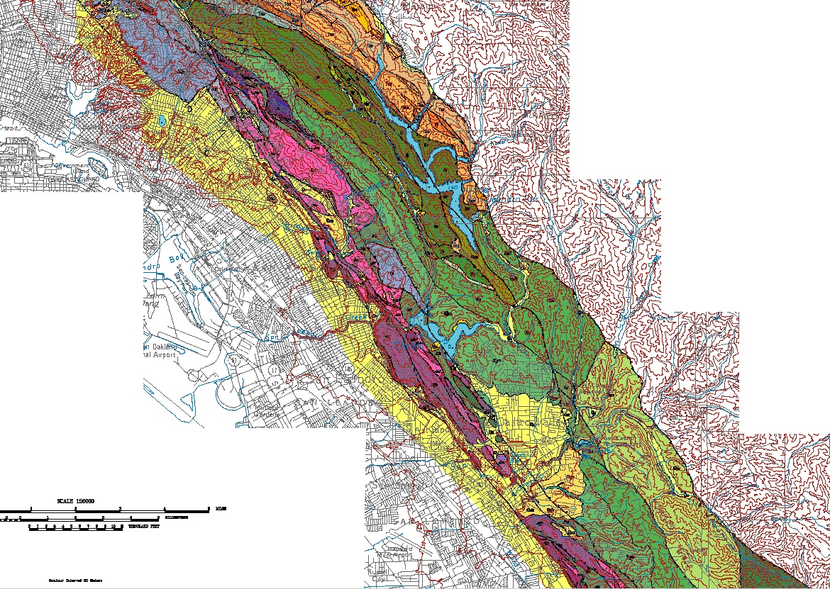
The Hayward fault zone, as described in this work, is a zone of highly deformed rocks, trending north 30 degrees west and ranging in width from about 2 to 10 kilometers. The historic earthquake generating activity has been concentrated in the western portion of the zone, but the zone as a whole reflects deformation derived from oblique right-lateral and compressive tectonic stress along a significant upper crustal discontinuity for the past 10 million or more years.
The Hayward fault zone is bounded on the east by a series of faults that demarcate the beginning of one or more structural blocks containing rocks and structures unrelated to the Hayward fault zone. The eastern bounding faults are, from the south, the Calaveras, Stonybrook, Palomares, Miller Creek, and Moraga faults. These faults are not considered to be part of the Hayward fault zone, although they are shown on the map to demarcate its boundary. The western boundary of the zone is less clearly defined, because the alluvium of the San Francisco Bay and Santa Clara Valley basins obscures bedrock and structural relationships. Although several of the westernmost faults in the zone clearly project under or through the alluvium, the western boundary of the fault is generally considered to be the westernmost mapped fault, which corresponds more or less with the margin of thick unconsolidated surficial deposits. The Hayward fault zone is truncated to the south by the Calaveras fault, which trends about north 10 west, and so forms an oblique east and south boundary. All of the faults within the southern part of the zone probably splay into the Calaveras fault. The northern margin of the zone as dealt with herein is San Pablo Bay, but the zone of deformation undoubtedly continues north of the Bay through the area bounded by the Rodgers Creek and Tolay faults.
Citation Information
| Publication Year | 1995 |
|---|---|
| Title | Geologic map of the Hayward fault zone, Contra Costa, Alameda, and Santa Clara counties, California: A digital database |
| DOI | 10.3133/ofr95597 |
| Authors | R. W. Graymer, D. L. Jones, E. E. Brabb |
| Publication Type | Report |
| Publication Subtype | USGS Numbered Series |
| Series Title | Open-File Report |
| Series Number | 95-597 |
| Index ID | ofr95597 |
| Record Source | USGS Publications Warehouse |
| USGS Organization | Geology, Minerals, Energy, and Geophysics Science Center |