
Jurassic rocks exposed in thurst-faulted structures near the southern limit of Western North Slope. In the subsurface farther north, these rocks may be reservoir rocks for natural gas.
Images
Browse images from a wide range of science topics covered by USGS.
Filter Total Items: 985

Tingmerkpuk Ridges
Jurassic rocks exposed in thurst-faulted structures near the southern limit of Western North Slope. In the subsurface farther north, these rocks may be reservoir rocks for natural gas.

Western North Slope Foothills
Geologist hikes across folded Cretaceous rocks in the central North Slope. These rocks were assessed by the USGS in 2017 and lie above the rocks assessed in the USGS 2021 Western North Slope assessment.
Geologist hikes across folded Cretaceous rocks in the central North Slope. These rocks were assessed by the USGS in 2017 and lie above the rocks assessed in the USGS 2021 Western North Slope assessment.

Weighing type precipitation gage and new radar-based sensor
Weighing type precipitation gage and new radar-based sensorThe Wolverine Glacier weather station was installed in 1968, and at 3250 ft is the highest elevation long-term weather record on the Kenai Peninsula. On October 19, 2020, USGS scientists upgraded the power system to a Lithium battery bank and installed a radar-based precipitation sensor (Lufft WS-100) to compare with the weighing based precipitation gage.

Tingmerkpuk Ridges
Geologists discuss the geology of Jurassic rocks in thurst-faulted structures near the southern limit of Western North Slope.
Geologists discuss the geology of Jurassic rocks in thurst-faulted structures near the southern limit of Western North Slope.

Kukpowruk Redwul
Geologist examines f Faulted and folded petroleum source rocks in Jurassic and Cretaceous rocks (Kingak Shale, pebble shale unit, and gamma-ray zone of Hue Shale) in southern part of Western North Slope. Thermal maturity of these rocks is at the upper limit of oil preservations.
Geologist examines f Faulted and folded petroleum source rocks in Jurassic and Cretaceous rocks (Kingak Shale, pebble shale unit, and gamma-ray zone of Hue Shale) in southern part of Western North Slope. Thermal maturity of these rocks is at the upper limit of oil preservations.

Surprise Creek, Western North Slope of Alaska
Overview of folded Triassic, Jurassic, and Cretaceous rocks in southern part of Western North Slope.
Overview of folded Triassic, Jurassic, and Cretaceous rocks in southern part of Western North Slope.

Kokolik River Oil Sand
Oil-saturated sandstone in the Nanushuk Formation in westernmost National Petroleum Reserve in Alaska (NPR-A). Oil in these rocks likely was generated beneath Western North Slope and migrated northeastward into NPR-A.
Oil-saturated sandstone in the Nanushuk Formation in westernmost National Petroleum Reserve in Alaska (NPR-A). Oil in these rocks likely was generated beneath Western North Slope and migrated northeastward into NPR-A.

Kukpowruk Redwul
Faulted and folded petroleum source rocks in Jurassic and Cretaceous rocks (Kingak Shale, pebble shale unit, and gamma-ray zone of Hue Shale) in southern part of Western North Slope. Thermal maturity of these rocks are at the upper limit of oil preservations.
Faulted and folded petroleum source rocks in Jurassic and Cretaceous rocks (Kingak Shale, pebble shale unit, and gamma-ray zone of Hue Shale) in southern part of Western North Slope. Thermal maturity of these rocks are at the upper limit of oil preservations.

Wolverine Glacier weather station on the Kenai Peninsula, Alaska
Wolverine Glacier weather station on the Kenai Peninsula, AlaskaThe Wolverine Glacier weather station was installed in 1968, and at 3250 ft is the highest elevation long-term weather record on the Kenai Peninsula.
Wolverine Glacier weather station on the Kenai Peninsula, Alaska
Wolverine Glacier weather station on the Kenai Peninsula, AlaskaThe Wolverine Glacier weather station was installed in 1968, and at 3250 ft is the highest elevation long-term weather record on the Kenai Peninsula.

Close up of the new radar precipitation sensor on the top of the pole
Close up of the new radar precipitation sensor on the top of the poleThe Wolverine Glacier weather station was installed in 1968, and at 3250 ft is the highest elevation long-term weather record on the Kenai Peninsula. Close up of the new radar precipitation sensor on the top of the pole. The crazy looking thing in the middle of the picture is an aspirated temperature sensor.

Upgraded Wolverine Glacier weather station, Alaska
Upgraded Wolverine Glacier weather station, AlaskaThe Wolverine Glacier weather station was installed in 1968, and at 3250 ft is the highest elevation long-term weather record on the Kenai Peninsula. In Ocotober 2020, USGS scientists upgraded the power system to a Lithium battery bank and installed a radar-based precipitation sensor (Lufft WS-100) to compare with the weighing based precipitation gage. The

Scientists record nearshore transects in Kachemak Bay, Alaska
Scientists record nearshore transects in Kachemak Bay, AlaskaBrian Robinson (USGS) and Ben Weitzman (NOAA) record observations along nearshore transects in Kachemak Bay, Alaska. USGS is studying the migration strategies and movement ecology of Black Oystercatchers as part of the new tracking study.

Caitlin Marsteller releases a Black Oystercatcher on beach in Alaska
Caitlin Marsteller releases a Black Oystercatcher on beach in AlaskaUSGS Biologist Caitlin Marsteller releases a Black Oystercatcher after assisting with the collection of morphometric data and tagging. Data were collected from Black Oystercatchers as part of a new study to better understand migration strategies and movement ecology of the species.

Caitlin Marsteller prepares to release a Black Oystercatcher, Alaska
Caitlin Marsteller prepares to release a Black Oystercatcher, AlaskaUSGS Biologist Caitlin Marsteller prepares to release a Black Oystercatcher after assisting with the collection of morphometric data and tagging. Data were collected from Black Oystercatchers as part of a new study to better understand migration strategies and movement ecology of the species.

Dragonfly Mercury Project specimen collection in Glacier NP
Dragonfly Mercury Project specimen collection in Glacier NPResearchers instruct volunteers on how to collect dragonfly larvae in Glacier NP as a part of the Dragonfly Mercury Project.
Dragonfly Mercury Project specimen collection in Glacier NP
Dragonfly Mercury Project specimen collection in Glacier NPResearchers instruct volunteers on how to collect dragonfly larvae in Glacier NP as a part of the Dragonfly Mercury Project.
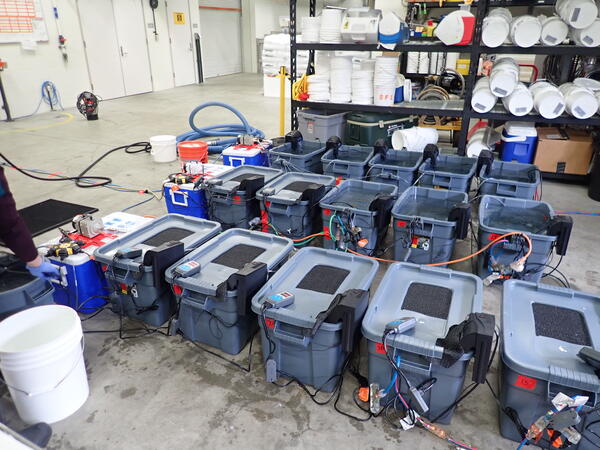
Experimental tanks used in a juvenile Pacific salmon heat stress experiment
Experimental tanks used in a juvenile Pacific salmon heat stress experimentExperimental tanks used in a juvenile Pacific salmon heat stress experiment for Chinook salmon (Oncorhynchus tshawytscha) and coho salmon (Oncorhynchus kisutch).
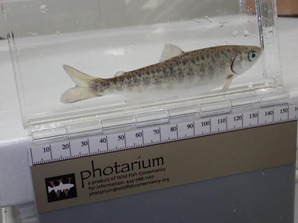
A juvenile Chinook salmon used in a heat stress experiment
A juvenile Chinook salmon used in a heat stress experimentA juvenile Chinook salmon (Oncorhynchus tshawytscha) used in a heat stress experiment. Alaska Department of Fish and Game’s William Jack Hernandez Sport Fish Hatchery, Anchorage, Alaska, USA.
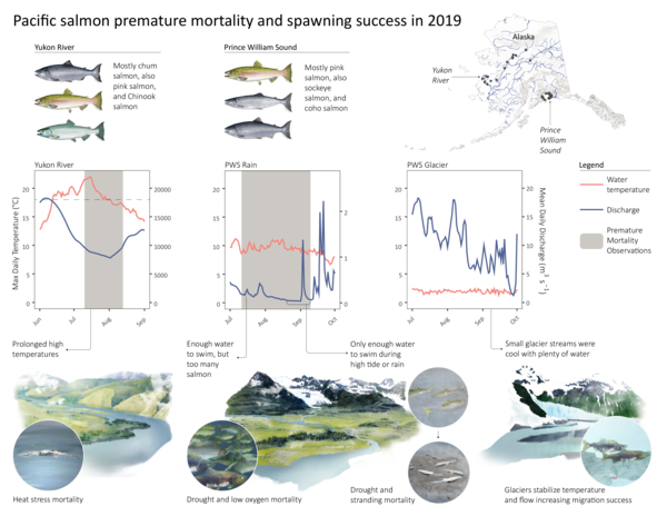
Infographic showing Pacific salmon premature mortality and spawning success in Alaska
Infographic showing Pacific salmon premature mortality and spawning success in AlaskaInfographic showing water temperature and discharge (flow) data from rivers with heat-related salmon mortality, drought-related salmon mortality, and normal salmon survival in Alaska during 2019.

Bokan Mountain, Alaska
Bokan Mountain, Alaska.

Keychain in Inupiaq for USGS outreach activities about bird banding
Keychain in Inupiaq for USGS outreach activities about bird bandingKeychain developed for USGS outreach activities about bird banding and reporting in Inupiaq and English. Inupiaq translation provided by Qaiyaan and Jana Harcharek.
Keychain in Inupiaq for USGS outreach activities about bird banding
Keychain in Inupiaq for USGS outreach activities about bird bandingKeychain developed for USGS outreach activities about bird banding and reporting in Inupiaq and English. Inupiaq translation provided by Qaiyaan and Jana Harcharek.

Tundra swan on the Colville River Delta, Alaska
Tundra swan on the Colville River Delta, Alaska 2013.
Tundra swan on the Colville River Delta, Alaska 2013.