Geology of Shenandoah National Park
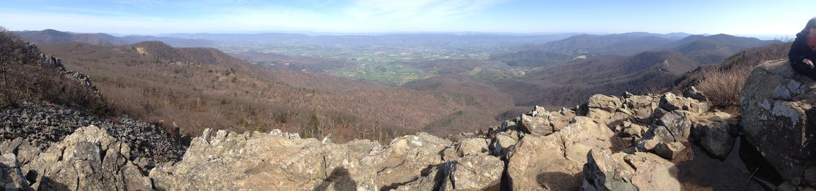
Shenandoah National Park is located in the state of Virginia, about 70 miles west of Washington, D.C. The park is known for its breathtaking views along scenic Skyline Drive, which runs down the spine of the park. The Appalachian Trail also goes through the park for a stretch of about 95 miles. This park has a rich geologic history, with ancient rocks formed over millions to billions of years.
Appalachian Mountains
To really understand the geology of Shenandoah National Park, we first have to look at the park’s setting. It is located in the Appalachian Mountains, an ancient mountain range in the eastern United States that started to form roughly 470 million years old, when separate landmasses started to converge. The end of their formation occurred about 270 million years ago, when the land that would become North America collided with what would become Africa. This movement of continents was caused by tectonic plate activity, meaning that portions, or plates, of Earth’s rocky crust are constantly moving toward, away from, and past each other. Tectonic plates move in tiny increments, about as fast as your fingernails grow, but over millions of years these tiny movements can have huge impacts! Tectonic plates collide at convergent plate boundaries, where enormous stress and pressure is placed on Earth’s crust and uplift and folding of rocks creates mountain ranges. There has also been extensive erosion of these mountains, starting about 100 million years ago. This erosion has removed much of the rock that makes up the mountains, and the rocks we see today are actually the cores that were at the center of these ancient behemoths. In fact, though the Appalachians are now relatively small compared to other mountains because of vast erosion over time. In their prime, their height rivaled that of the Himalayas!
Shenandoah National Park is nestled within the Blue Ridge province of the Appalachian Mountains, which extends from Pennsylvania southward. The Blue Ridge Mountains are more rounded than those farther west. This is because these are some of the older mountains in the Appalachian Range, and there has been more time for erosion to occur. Most of the erosion is due to streams flowing across the mountains, and this erosion has also created much of the soil in the park, which now supports the local ecosystems.
Ancient Rock
The oldest rocks in Shenandoah National Park have an approximate age of 1.1 billion years. To put that into perspective, the Earth is about 4.5, so these rocks are roughly a whole quarter of the age of Earth itself! They are so old that when they formed, our world looked completely different. The seven continents existed as one large supercontinent known as Pangea. The rocks that formed in this ancient Earth are known as the Old Rag Granite and the Pedlar Formation.
The Old Rag Granite is recognizable by its large visible crystals and its light color. It is very resistant to erosion from wind and water that wear away at rock. However, evidence of its erosion can still be seen. This happens because tiny cracks in the rock fill with water. When the water freezes into ice, it expands, putting pressure on the rocks. These cracks widen by tiny increments until they are enormous. Some have expanded to the point that boulders of the Old Rag Granite have up to 10 feet between them.
The other rock unit as old as the Old Rag Granite, the Pedlar Formation, is made of a rock called gneiss (pronounced “nice”). This type of rock can have excellent foliations, meaning that if you look at it, you can see distinct layers that look like stripes running across the rock. Not all of the Pedlar gneisses in the park are foliated, but this formation is most easily recognized by looking for these foliations. There are some excellent examples along Skyline Drive.
Metamorphosis
The Pedlar Formation is comprised of metamorphic rock, meaning that it has undergone significant physical or chemical changes since its formation. These rocks started out as igneous, or volcanic rocks, but were subjected to intense heat and pressure during the mountain-building event known as the Grenville Orogeny. These aren’t the only rocks in the park that have undergone metamorphosis.
The Catoctin Formation
About 570 million years ago, before the Appalachians started to form, there were extensive lava flows in the area. These were caused by a divergent plate boundary, a place where tectonic plates move away from each other. These moving plates opened up rifts in which allowed lava to rise up to the surface. This lava flowed across the surface of the Earth, covering over 4,000 square miles. For a frame of reference, these lava flows could have covered all of Delaware and Rhode Island combined.
The thickness of the lava flow depended on the topography of the region. The thinnest flow was 46 meters, and the thickest was 82 meters. For comparison, it is about 81 meters from the base of the statue of liberty to her head. While the lava was flowing across the rocks at Earth’s surface, the heat also metamorphosed the rocks beneath it, mostly granites and gneisses, to a rock called unakite, which is Virginia’s unofficial state rock. This unakite is very colorful and is primarily pink, yellow, and green because of the minerals it contains: potassium feldspar and epidote.
When the sea of lava finally cooled, it hardened into the rocks of the Catoctin Formation, named after Catoctin Mountain. Like the unakite it created, this formation contains the metamorphic rock, metabasalt and is particularly colorful, containing gray, green, and purple minerals. This name implies that the rock used to be basalt, a common igneous rock with a dark color. The rocks in the Catoctin Formation are primarily greenstone, which is a type of metabasalt aptly named for its color. This color is caused by the minerals present in the rock, primarily chlorite, actinolite, albite, epidote, titanite, quartz, and magnetite. In the Catoctin Formation, these minerals are aphanitic, meaning they are too small to be seen with the naked eye.
The formation of the Catoctin rocks didn’t happen all at once. There were many individual eruptions with enough time between them that the previous lava flow had time to cool. In some places, you can tell the different eruptions apart because they look like distinct layers, which are called benches.
Many of the waterfalls in the park flow over the Catoctin Formation rocks because these greenstones are often found on high ridges and peaks in the park. Dark Hollow Falls is one of the waterfalls which cascades over the Catoctin Formation. This waterfall drains much of the area of Big Meadows. The latter is a meadow of about five square miles at the crest of the Blue Ridge, right in the middle of Shenandoah National Park. Underneath Big Meadows, there are rocks of the Catoctin Formation at least 1,800 feet thick. If you visit the area, you can walk on top of ancient lava flows that are hundreds of millions of years old!
Igneous Structures
The Catoctin Formation rocks contains some fascinating volcanic structures. The first of these is pillow basalts. Pillow basalts are aptly named because they look like pillows, even though they are certainly not as soft as their name would imply. These structures form when lava flows into water, and they are quickly cooled from all sides. Pillow basalts are exposed near Dark Hollow Falls, east of Big Meadows, which formed when lava flowed into a body of water.
There is also columnar jointing, which is common feature of cooling basalts. When lava contracts under certain conditions, it can form polygonal cracks, which look like honeycomb from above. If you want to see these features, the best places to go are along the Appalachian Trail or along Skyline Drive at Indian Run Overlook.
Lastly, you can see volcanic breccias in the Catoctin Formation. These form when lava flows over older cooled lava and tears up pieces of the old, which are incorporated into the lava as it cools. The best place to see these is along Skyline Drive at the Franklin Cliffs Overlook. They are often an unusual white, dark purple, or green.
Metasedimentary Rocks
The same rifting that formed the Catoctin Formation is also responsible for the formation of the rocks belonging to the Chilhowee Group. As the two plates continued to drift further and further apart, a basin formed which allowed an ocean to take shape. This 500-million-year-old ocean was known as the Iapetus Ocean. As water levels rose and fell, they deposited the sediments they were carrying into this basin. The oldest and deepest rock of the Chilhowee Group formed when the water was low in this area. We know this because the sediments consist of gravel, pebbles, and sand, which represent deposits laid down by rivers.
When the ocean rose again, this area became covered in lagoons, in which sand, silt, and mud were deposited. As the water continued to rise, quartz sands dominated the area. The youngest layer of this group consists of shale and limestone, both of which are very fine-grained and form in deep water environments. By looking at these rocks, geologists can tell a lot about what the area used to look like.
The sedimentary rocks experienced metamorphism andthe rocks of the Chilhowee Group are called metasedimentary rocks. Today in Shenandoah National Park, the rocks of the Chilhowee Group form steep ridges and hollows that are covered in eroded rock debris called talus. These rocks have experienced weathering which has created soil able to support vegetation. However, the soils that have been produced are thin and sandy, and as a result, the vegetation that grows in them is generally smaller and less diverse than vegetation that grows in more fertile soils that are produced by the weathering of volcanic rocks.
Fracture
In many of the rocks in the park, you can see significant fractures, or cracks.. In some places, there are so many that they obscure the features of the rock that they run through. There are two different ways that these cracks have formed. The first is called cleavage. This happens when metamorphism and compression cause minerals in a rock to realign and then the rock breaks along mineral planes. Cleavage planes are usually spaced close together and are parallel. An example of cleavage is the Catoctin Formation, in which the high amount of chlorite has caused the rock to cleave in layers, creating a spiked and jagged appearance. Cleavage in this formation often cuts through the columnar joints mentioned earlier. This gives the joints a tilted look.
Jointing is the mechanism behind the other fractures in the rock. Jointing occurs not because of mineral planes, but because of regional pressures on the rock that cause it to break and move apart slightly. These joints are not as closely spaced as cleavage planes, nor are they as uniform. Jointing and cleavage are both common in the park.
Faults
Faults are planes of weakness in rocks, where movement occurs. They are common in areas that have experienced mountain building, such as the Appalachians. There are many faults in the park which tell a complex story. The first type of fault in the park is a thrust fault. To imagine a thrust fault, hold your hands level with your fingertips touching and then move one over the other. The hand on top represents the rocks of the Blue Ridge, which have been thrust up to form the mountains we see today. The actual faults in Shenandoah are often covered by sediments, soil, or rocks, so it is rare that we see them, but when we do, the rock at the fault boundary, which is subjected to massive amounts of pressure, is often pulverized into either fault breccia or fault gauge. Fault gauge consists of finely broken up fragments that can appear powdery. Fault breccia, on the other hand, has large angular pieces of rock in it along with smaller grains.
Found alongside these thrust faults are normal faults, which occur when rocks move away from each other, causing rock on one side of the fault to move downward. Geologists can tell the age of the faults in the park by comparing them. Imagine if you tore a piece of paper in half lengthwise, slid one half past the other so they no longer formed a rectangle, and then re-taped the paper. This tear represents a fault. Imagine then tearing the paper again, but along its shorter axis, and again sliding one side of the paper away from the other. You can tell that which tear formed first, because it will be disrupted by the second tear. In order for this to happen, the first tear must have already existed when the second formed. The same is true of faults. By looking at the faults in relation to each other, geologists can see that some of the normal faults formed before the thrust faults, and some formed after. Knowing their age helps with piecing together the rich geologic history of the region.
Folds
Folds form when there is enough heat and/or pressure to bend and shape the solid rock. This heat and pressure are common during orogenies like the ones that formed the Appalachians. Folds look like layers of rocks that have been curved or bent. There are both large and small folds in the park, and they are especially easy to see in the rocks of the Chilhowee Group.
Water Activity
Shenandoah has many stunning streams and waterfalls. These have been slowly eroding the area since it formed. When there is increased rainfall, the streams increase in speed and volume and pick up more loose sediments, making them look muddy. Sometimes, these streams can cause flooding and mudslides. What is more common are freeze and thaw cycles. Water naturally infiltrates into the soil and rock beneath it, moving through the tiny spaces between sediment or rock grains. When the weather is cold enough, this water freezes, and since water expands when it freezes, this leads to cracks and breaks in the rocks, causing occasional rockfalls.
Wind and Water Gaps
In Shenandoah National Park, there are many gorges, some of which are thousands of feet deep. These are called wind and water gaps. Water gaps have streams flowing through them. These streams eroded the gorges into the shapes they are today. A wind gap is a former water gap whose stream has dried up. They are aptly called wind gaps because of their tendency to funnel winds.
Acid Rain
Acid rain sounds cataclysmic, but technically all rain is slightly acidic. Acidity is measured by pH, which is a scale from 0-14, where lower numbers are more acidic and higher number are more basic (alkaline). For example, battery acid has a pH of 1. Seven indicates that something is neutral - neither acidic or basic. Normal rainwater has a pH of about 5.0-5.5 because rainwater also contains carbon dioxide, which when added to water creates carbonic acid (H2CO3, a weak acid), though in Shenandoah National Park, rain with a pH of 4.6 is not uncommon.
Rain is considered to be “acid rain” when the pH drops below 4.4.It can form when sulfur dioxide and nitrogen oxide in the atmosphere. Sulfur and nitrogen are put into the atmosphere in several different ways. For example, volcanoes and forest fires both give off these gases. However, human activity, like the burning of fossil fuels, also increases the concentration of these compounds in the atmosphere. Sulfur dioxide and nitrogen oxide convert to sulfuric acid and nitric acid, which then fall with precipitation.
After acid rain falls, it can become less acidic when it enters into streams. This is because streams have acid-neutralizing-capacity, or ANC. Eventually, the more basic water will neutralize the acidic water that has been added to it. The ability of these streams to neutralize acid rain has to do with the rocks that they flow over. The three categories of rocks underlying the park’s streams are basaltic, granitic, and siliciclastic. Basalt and granite are both types of volcanic rock, and siliciclastics are sedimentary rocks. Basaltic rocks are best at neutralizing acid rain, followed by granite, and finally siliciclastics. Steepness of a slope also has to do with ANC. Streams that flow over steep slopes move faster and have less of an opportunity to be neutralized. That is why gentler slopes generally have a higher acid neutralizing capacity.
Mining
In Shenandoah National Park and just to the west, there are over 40 abandoned mines. The metal manganese was mined starting in 1884. Later, during WW1 and WW2, mines were dug to assess the manganese in the park and its ability to be turned into steel to be used as a resource in the war. Ultimately, it was decided that the manganese in the park was unsuitable because it contained too much silica and phosphorus. In addition to manganese, copper was mined from the park from the 1850s to the 1940s. These mining efforts have long since ceased, but the remnants of the mines still stand. Many of the exploration trenches, open-cut mines, and shafts have filled with water and look like innocuous ponds. The most productive and largest mine, the Crimora Mine, which was an open-cut manganese mine, can be observed along Skyline Drive at the Crimora Lake Overlook.
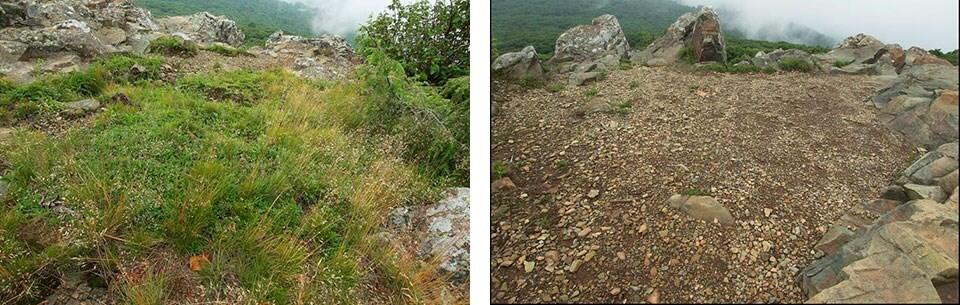
Rock Preservation in the Park
We don’t normally think of rocks as things that need to be protected, but some of the rock in Shenandoah need just this. Outcrops are places where rock is exposed, and not covered by plants or soil. They are often high in the mountains, providing beautiful views and housing rare and endangered plants and animals. Hiking, camping, and climbing have taken a toll on some cliff outcrops, which have been eroded and degraded. The National Park Service in Shenandoah monitors and manages these outcrops, and have reported that out of fifty outcroppings studied, 40% were negatively impacted by human use, including from graffiti and litter and hiking, mountain climbing, and camping activity which has led to degradation. To protect these areas, the park has implemented a plan called ROMP (Rock Outcrop Management Plan), which entails total or partial closures at high risk sites. This way, the outcrops will be protected for future visitors.