
ScienceBase Updates - Summer 2023
Summer 2023 topics include information on AGOL publishing for GIS data in ScienceBase, upcoming changes in Multi-Factor Authentication in ScienceBase, and a featured data release on lake temperature predictions.

Table of Contents
- AGOL Publishing for USGS GIS Data in ScienceBase
- Multi-Factor Authentication in ScienceBase
- Featured Data Release
- Did You Know? Resource Clean-Up

AGOL Publishing for USGS GIS Data in ScienceBase


As described in an earlier ScienceBase Update , ScienceBase staff have been working to integrate GIS map service publishing via the USGS ArcGIS Online (AGOL) instance directly from ScienceBase. Logged-in USGS users now have the option to upload a properly formatted .sd file to ScienceBase cloud file storage and generate an ArcGIS map service.
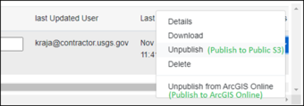
After the .sd file is uploaded to ScienceBase cloud storage, the user will need to publish the file to the publicly accessible ScienceBase S3 bucket. When the .sd file is in that location, users will see the option to publish the .sd file to the USGS AGOL space.
This workflow is designed to support geospatial data that are appropriate to be publicly accessible and can benefit from access via ESRI map services. Data should be appropriately reviewed for public sharing (e.g., a USGS data release or other finalized product) and cannot contain any personally identifiable information (PII), controlled unclassified information (CUI), or sensitive data. The ESRI services in AGOL are fully public if created in this route from ScienceBase because the ScienceBase connection to AGOL has been granted elevated permissions to support public service generation for defined cases as outlined above. No additional steps are required from the author to make services public. Services created in this way are not visible to a user when personally logged into AGOL; they are managed by a ScienceBase account, on behalf of the user from the item. Starting and stopping the service, or removing the .sd file, are all performed from the item page, similar to how ArcGIS Server-hosted ESRI services are managed from ScienceBase.
Additional information is available on the ScienceBase Instructions and Documentation site.
What about Existing Map Services?
With the USGS move toward cloud hosting for data and applications, the ScienceBase team is working to migrate existing ESRI map services from the on-premise ArcGIS Server resource to the USGS ArcGIS Online space. This will result in a change to the map service URL listed in the item JSON; however, users can expect better uptime and the ability to more easily work with these map services in AGOL. We are working with users on test cases now. If your ScienceBase community is interested in migrating ESRI map services to AGOL for existing items, please let our team know by contacting sciencebase@usgs.gov . At a future point, these ESRI services will be programmatically migrated in batches and we will communicate with item authors on the relevant details for updated service URLs for the items. No action should be required from item owners other than updating any external references or tool connections to these services.
Multi-Factor Authentication in ScienceBase
In compliance with forthcoming Department of Interior (DOI) and USGS security requirements, the ScienceBase team is working on implementing Multi-Factor Authentication (MFA) for the ScienceBase web application.
Upon completion, users will see a new login screen when authenticating into ScienceBase.
When not on the USGS network, USGS employees and contractors will need to log into ScienceBase with PIV card and AD credentials.
Current external ScienceBase users (myUSGS account holders with a USGS research sponsor) have been independently contacted via email about the forthcoming change and the requirement to obtain a Login.gov account (https://login.gov/). A login.gov account will provide USGS-sponsored external users a route for two-factor authentication. Please ensure any myUSGS ScienceBase collaborators that you may work with are aware of these new requirements and have followed up on the outlined instructions to ensure item permissions and user roles can be migrated where necessary.
The updated authentication requirements should not impact any API-based tools or workflows. Public item access (i.e., 'read only' use) will also not be impacted.
Please contact the ScienceBase team (sciencebase@usgs.gov) with any questions.
Featured Data Release

USGS Data Owner: Office of the Chief Operating Officer
Corson-Dosch, H.R., Mcaliley, W.A., Platt, L.R.C., Padilla, J.A., and Read, J.S., 2023, Daily water column temperature predictions for thousands of Midwest U.S. lakes between 1979-2022 and under future climate scenarios: U.S. Geological Survey data release, https://doi.org/10.5066/P9EQQER7.
Lake temperature is an important environmental metric for understanding habitat suitability for many freshwater species and is especially useful when temperatures are predicted throughout the water column (known as temperature profiles). In this data release, multiple modeling approaches were used to generate predictions of daily temperature profiles for thousands of lakes in the Midwest.
Although just released in June 2023, this data release’s landing page in ScienceBase has already been accessed over 100,000 times (according to the SBDR Dashboard). Additionally, the data release authors have released the related data prep and modeling repositories in GitHub, allowing easier reproducibility of the data.
Did You Know? Resource Clean-Up
Are you a data manager responsible for managing older content or project resources in ScienceBase? Or are you aware of old or duplicate landing pages that can be removed, or map services that are no longer being used? The ScienceBase team strives to ensure that we are presenting up-to-date and usable content in our public-facing search results, but we could use your help!
Contact sciencebase_datarelease@usgs.gov for help with cleanup efforts or strategies.