
ScienceBase Geospatial Services
Instructions for creating geospatial web services in ScienceBase.
Open Geospatial Consortium (OGC) Web Services
AWS S3 Publishing for Cloud-Optimized File Formats
ScienceBase Integration with USGS ArcGIS Online (AGOL)
- Publish a service definition (.sd) file from ScienceBase to USGS AGOL
- Create a service definition (.sd) file for USGS AGOL in ArcPro
- Service definition best practices
- Access data from a service definition
Please note: hosting GIS mapping services is resource intensive for the ScienceBase system, so please only create these services if users are expected to interact with the data through the service. To provide a simple preview image of data, a static image (in either .jpg or .png format) can be uploaded instead.
Open Geospatial Consortium (OGC) Web Services
ScienceBase uses a cloud-based Geoserver instance to create services for both shapefile and GeoTIFF formats.
Shapefiles
A shapefile comprises of a set of files that can be uploaded as individual files or as a single zipped file. ScienceBase can generate WMS (web mapping service) and WFS (web feature service) for unzipped shapefiles uploaded through the Cloud Upload tool.
A projection (.prj) file must be included in the shapefile bundle to render and create GIS services. The WMS and WFS service URLs are displayed in the "Spatial Services" section under the preview map on a ScienceBase item. The default symbology is a solid blue outline. WGS84 Web Mercator projection is recommended if services will be combined with publicly available basemaps (e.g., from ArcGIS Online or Google).

Rasters
Any raster format can be uploaded to ScienceBase; however, only GeoTIFF (.tif) files can be parsed by ScienceBase and used to create GIS services. The generated WMS and WCS URLs are displayed in the "Spatial Services" section under the preview map on a ScienceBase item. A blue color ramp is the default symbology. WGS84 Web Mercator projection is recommended if services will be combined with publicly available basemaps (e.g., from ArcGIS Online or Google).

Instructions
To start a service, upload vector data (shapefiles for points, lines, or polygons) or raster data (GeoTIFF files) into ScienceBase cloud storage. Use the "Cloud Upload / File Management" tool in the "Item Actions" section of a ScienceBase item:

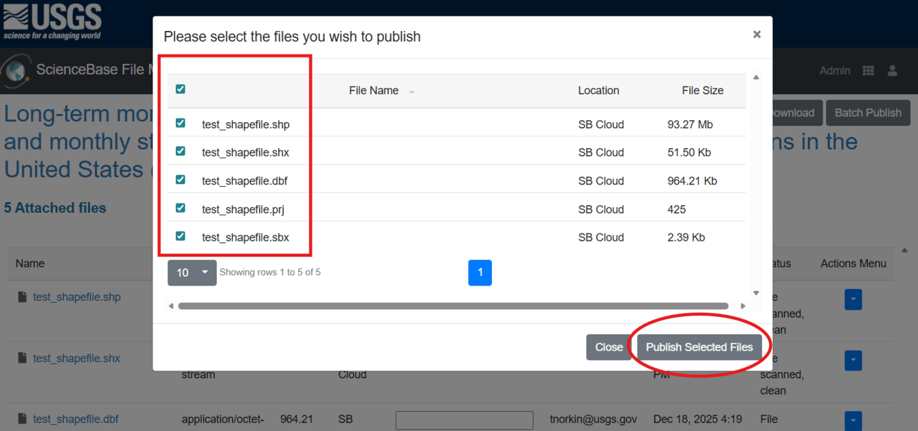
This workflow creates public OGC map services. Users must ensure that any datasets do not contain sensitive information or PII prior to using this feature. After uploading the GIS files, users will need to push a copy of the files to the public-facing ScienceBase S3 storage. This step is performed from the Manager interface or via the ScienceBase API. Users should ensure they upload and publish all component files associated with a shapefile or raster dataset.
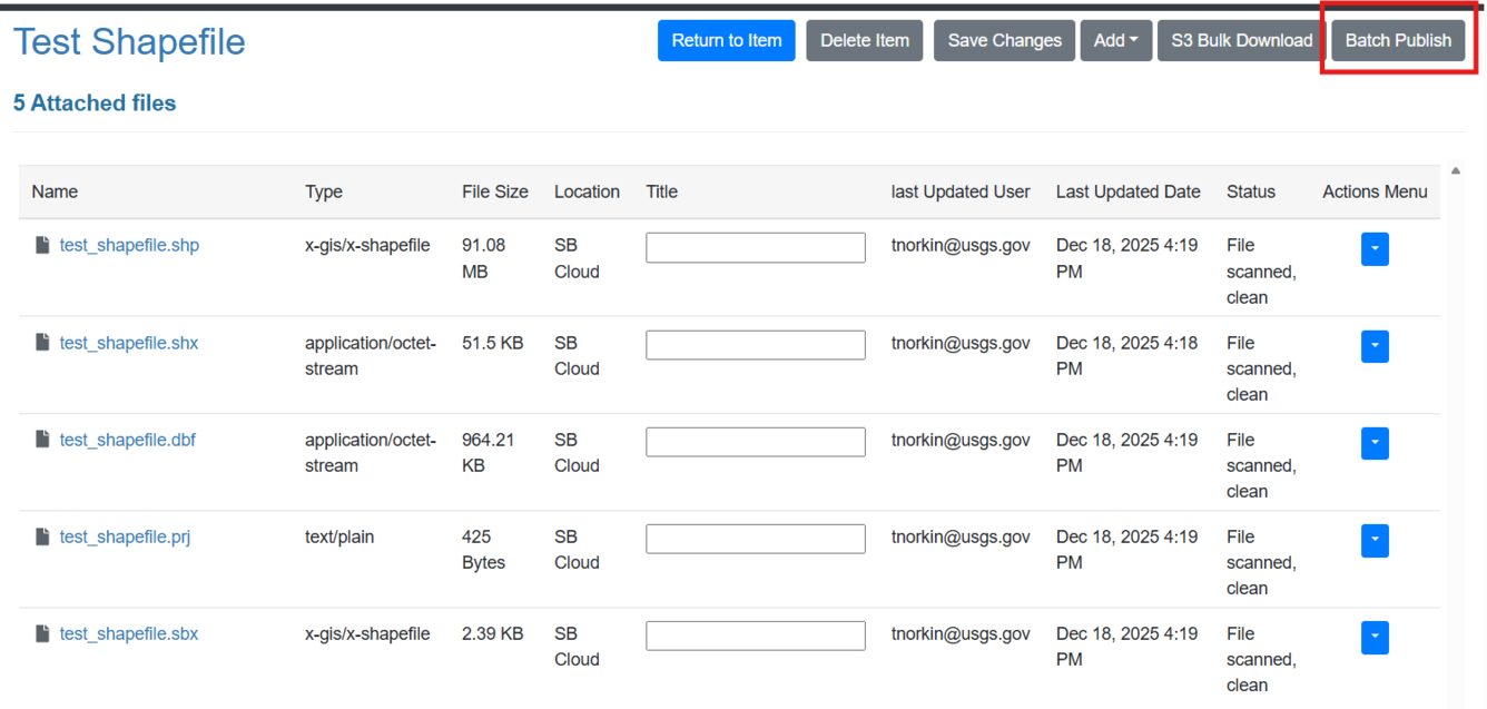
Select "Batch Publish" to publish multiple files at once:
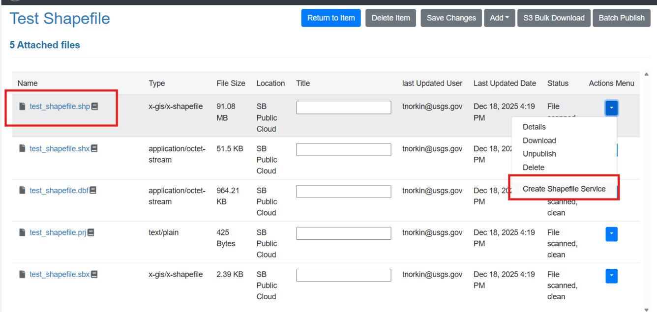
After the component files have been moved to the public S3 storage:
- For shapefiles, find the .shp file, click on the "Actions Menu" dropdown, and select 'Create Shapefile Service'.
- For rasters, find the .tif file, click on the "Actions Menu" dropdown, and select 'Create Raster Service'.
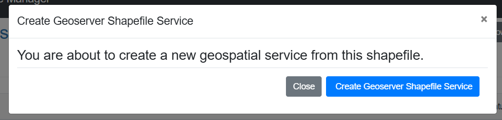
A prompt will ask the user to confirm.
The resulting map service will be visible on the item page. The map service URLs will also be displayed.
Data Symbology
For both shapefiles and rasters, ScienceBase will default to blue symbology. To customize your symbology, you can use one of the following methods:
- Upload an ESRI service definition (.sd) file to ScienceBase. The process is explained below in the section about "map service integration".
- Add open source symbology to an uploaded shapefile or raster. For example, Styled Layer Descriptor (SLD) files can be included with shapefile or GeoTIFF data to add custom symbology rules to a WMS display. Note: an SLD file needs to be named with the same file prefix as the related shapefile or GeoTIFF for ScienceBase to recognize it as a symbology layer.
Shapefile:
- Example instructions on how to create a .sld file for a shapefile in QGIS
Raster (two options):
- Example instructions on how to create a .sld file for a raster in QGIS
- Add a colormap to a GeoTIFF file bundle (for single-band rasters that are stored as 8 or 16-bit unsigned integer). If the GeoTIFF contains a colormap, ScienceBase will render the raster accordingly.

AWS S3 Publishing for Cloud-Optimized Formats
Please note: this feature is intended for finalized and approved USGS data products that have been structured for use with this type of access protocol.
ScienceBase has a feature that allows authorized users to publish files to a publicly readable ScienceBase AWS S3 bucket. When performed, the files are moved to a dedicated ScienceBase bucket where they are directly readable from object storage at a Uniform Resource Identifier (URI). The ability to access a file in this way (i.e., direct read from cloud storage) has multiple benefits for data stored in cloud optimized formats. One case that this workflow supports is for Cloud Optimized GeoTIFFs (COG) files.
Raster files are often large in size, for example, when the data cover a large spatial extent or are captured at a high spatial resolution. A COG file provides the same data and functionality as a traditional GeoTIFF, but includes additional information in the file to support faster rendering of the dataset (pyramids) and subsetting over http protocol. Publishing raster files in a COG format and storing them in a publicly readable location allows users to access the data (the full dataset or geographically bounded subsets), view it dynamically in a map viewer, and pull raw values directly into a programmatic workflow (e.g., in Python or R). This enables more flexible code-based workflows and, in many cases, eliminates the need for downstream users to download entire files.
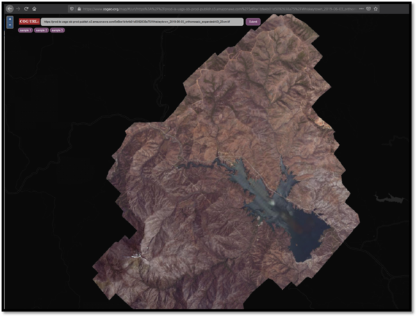
For example, the following image shows a ScienceBase COG file, read directly from ScienceBase into an online viewer. The viewer supports rapid zoom and display, illustrating the benefits of cloud-optimized storage formats and standardized access protocols. The file can be viewed here.
To make a file available to cloud workflows, navigate to the ScienceBase File Manager, which can be accessed from the "Item Actions" section on ScienceBase items:
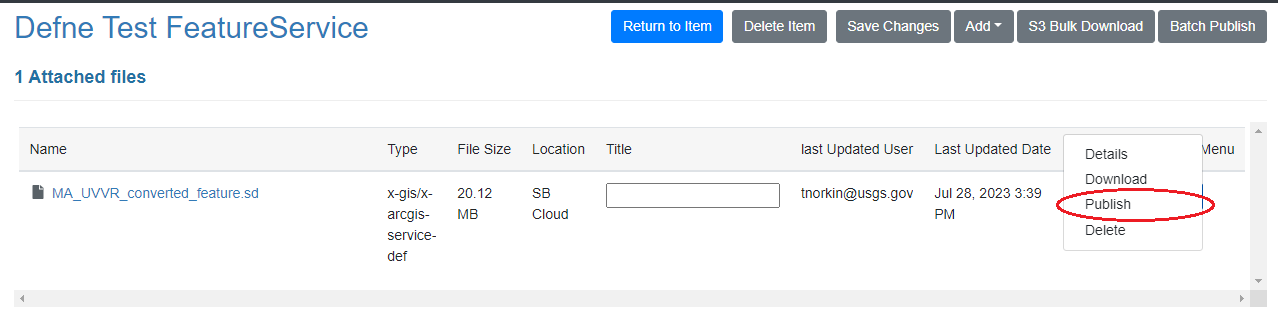
Click the "Actions Menu" dropdown arrow next to the cloud optimized file and select "Publish." This action will add a copy of the file to the public ScienceBase S3 bucket and will add the public S3 URI to the item JSON, which can then be shared with users.
ScienceBase Integration with USGS ArcGIS Online (AGOL)
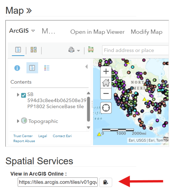
ScienceBase supports a process for USGS authors to publish reviewed and finalized GIS data to the USGS ArcGIS Online (AGOL) instance. After uploading a well-formatted ESRI .sd file to an item via the ScienceBase cloud uploader, the user can elect to start a public service in AGOL. This process will create an ESRI map service and update the ScienceBase item JSON with the ESRI map service URL. The item show page will display a small inset map of the AGOL service and the service URL (shown in the screenshot below).
Currently 2 types of ESRI map services are supported: the Web Map Tile Service (WMTS) and Web Feature Server (WFS) options.
Please note:
- Data should be reviewed and approved for public sharing (as a USGS data release or other finalized product) before being published.
- Data cannot contain any personally identifiable information (PII), controlled unclassified information (CUI), or sensitive data.
- Services in AGOL are fully public if created in this route from ScienceBase. The ScienceBase connection to AGOL has been granted elevated permissions to support public service generation for defined cases as outlined above. No additional steps are required from the author to make services public.
- Services created in this way are not visible to a user when logged into their personal AGOL account; services can only be managed through ScienceBase. Starting and stopping the service, or removing the .sd file, are all performed from the item page in ScienceBase.
- Service definition (.sd) files must be properly formatted for AGOL from a licensed USGS instance of ESRI ArcGIS Pro. See instructions below for creating an .sd file in ArcPro.
Publish a service definition (.sd) file from ScienceBase to USGS AGOL
Upload the properly formatted .sd file using the ScienceBase File Manager (not the traditional "Manage Item" > "Edit Item" method). The File Manager can be accessed from the "Item Actions" section at the bottom of the page.
After the .sd file is uploaded to ScienceBase cloud storage, publish the file to the publicly accessible ScienceBase S3 bucket:

Users will then see the option to publish the .sd file to the USGS AGOL space:

Users will receive an email notification to let them know that the service has been created (note: there may be a delay before the email is received).
There are limited AGOL credits allocated for the USGS, so please be aware of the amount of data being published to AGOL through ScienceBase. If AGOL services are no longer required, please follow these instructions in reverse to unpublish the AGOL service and unpublish the .sd file from the public ScienceBase S3 bucket.
How to create a service definition (.sd) file for USGS AGOL in ArcPro
Start by working within local GIS software to create the dataset.
USGS users must be logged in to ArcGIS Online (AGOL) within ArcPro before creating the .sd file. If an .sd file is created while the user is logged out, the service will not work in AGOL.

Log in with the "USGS PIV Login" option:

Right click on the name of the map in the contents pane. Select "Save As Offline Service Definition", then "Web Layer on Portal":

Select "ArcGIS Online" as the version. This selection limits the "Layer Type" field to two types, "Feature" and "Tile". Select the one that applies to your dataset.
Before saving, click "Analyze" to identify errors or warnings:

Once there are no errors or warnings, click "Save".

Tips for ESRI service definition files that maximize REST service performance:
- Please note: creating a .sd file will copy the ENTIRE dataset from your ArcPro project, not just what is seen in the current data frame extent. This has the potential to create very large, unmanageable files.
- In the process of creating an .sd file, make an attempt to fix "Warnings" and "Informational Messages" in the "Analyze" step to further improve performance.
- Make sure all datasets and data frames use the same coordinate system. Failure to do so can result in a service slowed by on-the-fly projection.
- If the service will be combined with publicly available basemaps (e.g., from ArcGIS Online), it is strongly recommended to use a projection that matches the standard coordinate system of these basemaps: Projected Coordinate Systems > World > WGS 1984 Web Mercator (auxiliary sphere). Failure to do so can result in a service slowed by on-the-fly projection.
- When authoring your map document, set large complex datasets to only display when zoomed-in.
- Avoid using highly complex, large datasets that contain too many vertices. Examples of datasets that can cause a slow service include raster datasets that have been converted to vector (the original raster dataset should be used instead) and complex multipolygons with many vertices.
- Use the "Simplify" tool to help overcome the problem of a slow service with too many vertices: ArcToolbox > Cartography Tools > Generalization > Simplify Line/Polygon. Use the "point remove" method and experiment to find the right balance of speedy performance versus accurate representation of the data.
- Click File > Map Document Properties and fill in the form to the best of your abilities. This will be used as metadata for your service.
- Make sure to generate pyramids for all raster datasets.
- Large raster datasets should use compression. We recommend converting all rasters to .tif format using LZW or LZ77 compression. Failure to do so can lead to unfavorable file size, slower performance, and problems in the unpackaging/unzipping process.
Access data from a service definition (.sd) file
A service definition file is a zipped bundle that contains the service properties, capabilities, and the original GIS data. To access the data on a local system, download the .sd file from ScienceBase and use unzipping software to unzip the file.
Connect to an ArcGIS REST service
Open the service URL in a web browser to view the connection options:
