
How is Earth MRI making an impact? Here are stories of Earth MRI in action.
Earth MRI is modernizing mapping of the Nation's surface and subsurface. We deliver high-quality data needed to understand our Nation's geology, find new critical and other mineral resources, and inform decisions about how the Nation will meet its evolving needs.
Explore our impact through video


Explore our impact through stories
Transforming Mineral Resource Knowledge
Understanding geologic resources
Strengthening the geoscience workforce
Supporting resilient planning
Advancing innovation
Including new case studies
New case studies
Explore our impact by region
These handouts describe the impacts and progress of Earth MRI in five regions.
Rocky Mountains and Northwest
Midwest and great plains
Northeast and mid-atlantic
Southwest
Southeast
Stories

A Critical Mineral Prospect in Maine
In Maine, a new critical mineral prospect was identified when an Earth MRI airborne radiometric survey detected anomalous values of thorium and uranium in a remote region of the state. Follow-up sampling and geochemical analyses by the Maine Geological Survey and University of Maine at Presque Isle identified elevated levels of rare earth elements, niobium, and zirconium in the rocks.
New Insights on Graphite
Graphite is a critical mineral used in advanced electronics essential the defense and energy sectors. Earth MRI data are shedding light on graphite resources, including in the Alabama graphite belt, in the Laramie Mountains of Wyoming, and on the Seward Peninsula of Alaska. The data are being incorporated into a USGS assessment of graphite mineral resources across the Nation. Local industries are also using the data to identify potential feasible resources in the states. In Wyoming, graphite claims have been made in the Earth MRI project area.
New Views of the Idaho Cobalt Belt
Earth MRI will soon complete geophysical surveys of the entire Idaho cobalt belt, a geologic strip of Idaho containing various mineral resources. Earth MRI data are providing a high-resolution three-dimensional view of this important geologic area, and spurring investment interest in the area. Cobalt is a critical mineral used in many renewable energy technologies, and is currently predominantly produced in the Democratic Republic of Congo.
Critical Minerals in Mine Wastes and other Unconventional Places
Earth MRI is helping to develop the first-ever National Mine Waste Inventory. This inventory will help identify mine wastes with the potential for recovering critical minerals, and aid in prioritizing and tracking mine waste remediation projects. Earth MRI is also providing the data to understand potential mineral resources in sands, soils and surface rock.
An Ancient Rift and Geologic Hydrogen
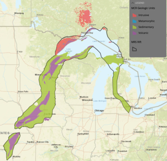
In western Iowa, Earth MRI geophysical data are helping scientists “see” into a 1-billion-year-old rift where the North American continent once tried to split in half. In addition to having potential mineral resources, this area is also a promising location for geologic hydrogen, a potential renewable energy resource.
Seeing Through the Trees
Earth MRI LiDAR data collected in western Oregon will help provide information about groundwater resources and natural hazards in a region where LiDAR can penetrate through the thick forests to show features on the Earth’s surface.
Geothermal Energy in the Great Basin
Earth MRI has collected geophysical, geochemical, geologic and hyperspectral data across the Great Basin. These data are being used to understand the potential for geothermal energy production, including co-production with critical minerals like lithium. The data are also providing important information about groundwater quantity and quality, hazards, soil qualities, and mine wastes in the area.
Geoscience Education
In New Mexico, over a dozen university students funded to work on Earth MRI projects have gained expertise and skills underrepresented in the Nation’s workforce. The Earth MRI group is the nucleus of a larger cohort of rising geologists who are working on similar projects: several undergraduates have been able to leverage ongoing research related to Earth MRI work to obtain outside employment. One student is now working as a staff scientist for the New Mexico Bureau of Geology.
Reinvestment in a State Geological Survey
Spurred in part by Earth MRI funding, Michigan has reinvested in its State Survey. Since 2023, the Michigan Geological Survey has expanded from 1 to 18 full-time staff. The revitalized Survey now has the capacity to partner with Earth MRI and other entities to map the natural resources of Michigan, including potentially valuable mineral deposits, and has brought significant funding via grants back to the State.

Hurricane Aftermath
After the destruction of Hurricanes Fiona and Ian, Earth MRI geophysical surveys are helping Puerto Rico and Florida to better understand local geologic hazards and find geologic materials that could be used to rebuild and strengthen infrastructure. In Puerto Rico, additional hyperspectral data are also helping to identify future landslide threats, including in areas that lack roads or are otherwise difficult to reach.
Revealing Hidden Hazards
Earth MRI geophysical data in South Carolina have revealed deep fault structures in the state that have caused earthquakes in the past. Earth MRI also recently completed a geophysical survey in the Salton Sea area in California, where the data revealed newly discovered faults at the southern end of the San Andreas Fault.
Identifying Infrastructure Risk
In Connecticut, Earth MRI mapping is helping to identify risks to concrete foundations. Pyrrhotite, a mineral that occurs in CT and in the surrounding states, can cause concrete foundations to fail. By mapping where pyrrhotite occurs, the state can better avoid using geologic units heavy in the mineral as materials for construction.
Accelerating Mineral Resource Assessments
Earth MRI is supporting a partnership effort between USGS and the Defense Advanced Research Project Agency (DARPA) to rapidly speed up assessments of potential critical mineral resources in the U.S. The partnership is developing ways of using AI and Earth MRI data to increase the speed and accuracy of mineral assessments, which have traditionally required long manual processes.

Finding Orphaned Wells
Orphaned wells are oil and gas wells that are no longer in production and have no legal owner. There are likely many orphaned wells that are undocumented across the Nation. In Illinois, Earth MRI airborne magnetic data may prove to be a tool for identifying orphaned wells in the Illinois Basin.
Rare Earth Elements in Soils
In Maryland, Earth MRI data are being used to understand rare earth elements in soils. Earth MRI is mapping the geology and geochemistry of areas of weathered rock that have generated soils elevated in rare earth elements. This research is illuminating the processes by which rock weathers into soils rich in rare earth elements. Soils rich in rare earth elements have not been well researched but occur in several places in the U.S. and could be a potential future source of valuable minerals.
How is Earth MRI making an impact? Here are stories of Earth MRI in action.
Earth MRI is modernizing mapping of the Nation's surface and subsurface. We deliver high-quality data needed to understand our Nation's geology, find new critical and other mineral resources, and inform decisions about how the Nation will meet its evolving needs.
Explore our impact through video
Explore our impact through stories
Transforming Mineral Resource Knowledge
Understanding geologic resources
Strengthening the geoscience workforce
Supporting resilient planning
Advancing innovation
Including new case studies
New case studies
Explore our impact by region
These handouts describe the impacts and progress of Earth MRI in five regions.
Rocky Mountains and Northwest
Midwest and great plains
Northeast and mid-atlantic
Southwest
Southeast
Stories
A Critical Mineral Prospect in Maine
In Maine, a new critical mineral prospect was identified when an Earth MRI airborne radiometric survey detected anomalous values of thorium and uranium in a remote region of the state. Follow-up sampling and geochemical analyses by the Maine Geological Survey and University of Maine at Presque Isle identified elevated levels of rare earth elements, niobium, and zirconium in the rocks.
New Insights on Graphite
Graphite is a critical mineral used in advanced electronics essential the defense and energy sectors. Earth MRI data are shedding light on graphite resources, including in the Alabama graphite belt, in the Laramie Mountains of Wyoming, and on the Seward Peninsula of Alaska. The data are being incorporated into a USGS assessment of graphite mineral resources across the Nation. Local industries are also using the data to identify potential feasible resources in the states. In Wyoming, graphite claims have been made in the Earth MRI project area.
New Views of the Idaho Cobalt Belt
Earth MRI will soon complete geophysical surveys of the entire Idaho cobalt belt, a geologic strip of Idaho containing various mineral resources. Earth MRI data are providing a high-resolution three-dimensional view of this important geologic area, and spurring investment interest in the area. Cobalt is a critical mineral used in many renewable energy technologies, and is currently predominantly produced in the Democratic Republic of Congo.
Critical Minerals in Mine Wastes and other Unconventional Places
Earth MRI is helping to develop the first-ever National Mine Waste Inventory. This inventory will help identify mine wastes with the potential for recovering critical minerals, and aid in prioritizing and tracking mine waste remediation projects. Earth MRI is also providing the data to understand potential mineral resources in sands, soils and surface rock.
An Ancient Rift and Geologic Hydrogen
In western Iowa, Earth MRI geophysical data are helping scientists “see” into a 1-billion-year-old rift where the North American continent once tried to split in half. In addition to having potential mineral resources, this area is also a promising location for geologic hydrogen, a potential renewable energy resource.
Seeing Through the Trees
Earth MRI LiDAR data collected in western Oregon will help provide information about groundwater resources and natural hazards in a region where LiDAR can penetrate through the thick forests to show features on the Earth’s surface.
Geothermal Energy in the Great Basin
Earth MRI has collected geophysical, geochemical, geologic and hyperspectral data across the Great Basin. These data are being used to understand the potential for geothermal energy production, including co-production with critical minerals like lithium. The data are also providing important information about groundwater quantity and quality, hazards, soil qualities, and mine wastes in the area.
Geoscience Education
In New Mexico, over a dozen university students funded to work on Earth MRI projects have gained expertise and skills underrepresented in the Nation’s workforce. The Earth MRI group is the nucleus of a larger cohort of rising geologists who are working on similar projects: several undergraduates have been able to leverage ongoing research related to Earth MRI work to obtain outside employment. One student is now working as a staff scientist for the New Mexico Bureau of Geology.
Reinvestment in a State Geological Survey
Spurred in part by Earth MRI funding, Michigan has reinvested in its State Survey. Since 2023, the Michigan Geological Survey has expanded from 1 to 18 full-time staff. The revitalized Survey now has the capacity to partner with Earth MRI and other entities to map the natural resources of Michigan, including potentially valuable mineral deposits, and has brought significant funding via grants back to the State.
Hurricane Aftermath
After the destruction of Hurricanes Fiona and Ian, Earth MRI geophysical surveys are helping Puerto Rico and Florida to better understand local geologic hazards and find geologic materials that could be used to rebuild and strengthen infrastructure. In Puerto Rico, additional hyperspectral data are also helping to identify future landslide threats, including in areas that lack roads or are otherwise difficult to reach.
Revealing Hidden Hazards
Earth MRI geophysical data in South Carolina have revealed deep fault structures in the state that have caused earthquakes in the past. Earth MRI also recently completed a geophysical survey in the Salton Sea area in California, where the data revealed newly discovered faults at the southern end of the San Andreas Fault.
Identifying Infrastructure Risk
In Connecticut, Earth MRI mapping is helping to identify risks to concrete foundations. Pyrrhotite, a mineral that occurs in CT and in the surrounding states, can cause concrete foundations to fail. By mapping where pyrrhotite occurs, the state can better avoid using geologic units heavy in the mineral as materials for construction.
Accelerating Mineral Resource Assessments
Earth MRI is supporting a partnership effort between USGS and the Defense Advanced Research Project Agency (DARPA) to rapidly speed up assessments of potential critical mineral resources in the U.S. The partnership is developing ways of using AI and Earth MRI data to increase the speed and accuracy of mineral assessments, which have traditionally required long manual processes.
Finding Orphaned Wells
Orphaned wells are oil and gas wells that are no longer in production and have no legal owner. There are likely many orphaned wells that are undocumented across the Nation. In Illinois, Earth MRI airborne magnetic data may prove to be a tool for identifying orphaned wells in the Illinois Basin.
Rare Earth Elements in Soils
In Maryland, Earth MRI data are being used to understand rare earth elements in soils. Earth MRI is mapping the geology and geochemistry of areas of weathered rock that have generated soils elevated in rare earth elements. This research is illuminating the processes by which rock weathers into soils rich in rare earth elements. Soils rich in rare earth elements have not been well researched but occur in several places in the U.S. and could be a potential future source of valuable minerals.