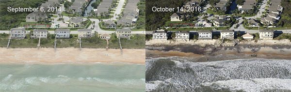
Vilano Beach, FL: Low altitude oblique aerial photographs taken before Hurricane Matthew (Sept. 6, 2014) and after (Oct. 14, 2016) show that storm waves and currents eroded a 16-foot-high san dune, exposing old seawalls and washing away boardwalks and decks.
Images

Vilano Beach, FL: Low altitude oblique aerial photographs taken before Hurricane Matthew (Sept. 6, 2014) and after (Oct. 14, 2016) show that storm waves and currents eroded a 16-foot-high san dune, exposing old seawalls and washing away boardwalks and decks.
Low-altitude oblique photography taken before Hurricane Matthew (Sept. 6, 2014) and after (Oct. 13, 2016) in Flagler Beach, FL, shows that waves washed away part of Highway A1A and obliterated a 5.2-meter (17-foot) dune.
A week after Hurricane Matthew slammed through southwestern Haiti on October 4, 2016, Landsat 8's Operational Land Imager sensor provided dramatic documentation of the scope of destruction in the Caribbean country.