
An IfSAR DEM image (left) is highlighting the presence of several steep-sided pingos and thaw lake basins (right) in an otherwise flat Arctic coastal plains topography. IfSAR data was collected for Alaska between 2012-2020.
Alena Giesche, Ph.D.
Alena is a Geologist at the Alaska Science Center, specialized in climate science and hazards.
Alena studies how hazards such as landslides are impacted by climate and permafrost thaw. More broadly, she researches past, present, and future climate and the evolution of Earth's landscapes. She has previously investigated a wide range of environments (arctic, alpine, desert, tropical, marine) using a diverse array of methods and archives (geochemical analyses, lake sediments, speleothems from caves, marine microfossils, ecological monitoring, snow depth and permafrost mapping). She mainly studies modern and Holocene (past 11,700 years) environmental conditions using geochemical proxies (stable isotopes, trace elements) and climate data, linking these findings to archaeological studies, as well as creating surficial geologic maps with environmental datasets.
Science and Products
An IfSAR DEM image (left) is highlighting the presence of several steep-sided pingos and thaw lake basins (right) in an otherwise flat Arctic coastal plains topography. IfSAR data was collected for Alaska between 2012-2020.

Permafrost zones across Alaska
This map depicts the permafrost zones across Alaska, overlain by project focus areas. The hashed turquoise region represents areas where pingo mapping is being prioritized. The lime green color outlines the 1002 area, where surficial geological maps are being used to generate more reliable predictors for ground ice content.
This map depicts the permafrost zones across Alaska, overlain by project focus areas. The hashed turquoise region represents areas where pingo mapping is being prioritized. The lime green color outlines the 1002 area, where surficial geological maps are being used to generate more reliable predictors for ground ice content.

Pingo 1
An IfSAR DEM image (left) is highlighting the presence of several steep-sided pingos and thaw lake basins. IfSAR data was collected for Alaska between 2012-2020.
An IfSAR DEM image (left) is highlighting the presence of several steep-sided pingos and thaw lake basins. IfSAR data was collected for Alaska between 2012-2020.

Pingo 2
An IfSAR DEM image of thaw lake basins (right) in an otherwise flat Arctic coastal plains topography. IfSAR data was collected for Alaska between 2012-2020.
An IfSAR DEM image of thaw lake basins (right) in an otherwise flat Arctic coastal plains topography. IfSAR data was collected for Alaska between 2012-2020.

Ground temperature monitoring
A scientist is examining the cable number from a set of legacy borehole sites for permafrost ground temperature monitoring in Utqiagvik, Alaska (part of USGS research at the Naval Arctic Research Laboratory from the 1950s to 1970s).
A scientist is examining the cable number from a set of legacy borehole sites for permafrost ground temperature monitoring in Utqiagvik, Alaska (part of USGS research at the Naval Arctic Research Laboratory from the 1950s to 1970s).
Legacy borehole site, Alaska
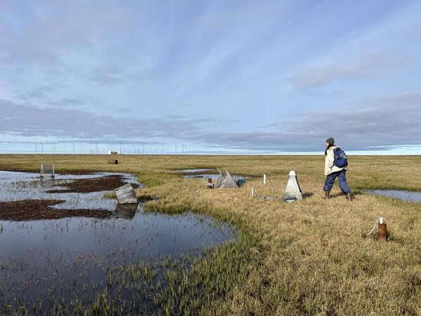
A scientist is walking by a set of legacy borehole sites for permafrost ground temperature monitoring in Utqiagvik, Alaska (part of USGS research at the Naval Arctic Research Laboratory from the 1950s to 1970s). Some of the wooden housings that covered these boreholes have since toppled over; others are submerged in pools of the thawing landscape.
A scientist is walking by a set of legacy borehole sites for permafrost ground temperature monitoring in Utqiagvik, Alaska (part of USGS research at the Naval Arctic Research Laboratory from the 1950s to 1970s). Some of the wooden housings that covered these boreholes have since toppled over; others are submerged in pools of the thawing landscape.

Permafrost ground temperature monitoring
A scientist is holding the cable top at a recently relocated site for permafrost ground temperature monitoring in Utqiagvik, Alaska (part of USGS research at the Naval Arctic Research Laboratory from the 1950s to 1970s).
A scientist is holding the cable top at a recently relocated site for permafrost ground temperature monitoring in Utqiagvik, Alaska (part of USGS research at the Naval Arctic Research Laboratory from the 1950s to 1970s).

Arctic speleothem
A cross-section of an Arctic speleothem showing growth layers of calcite deposited over hundreds of thousands of years. This speleothem only grew during intervals of past permafrost thaw (i.e., interglacials), when drip water could percolate into the cave through the unfrozen epikarst.
A cross-section of an Arctic speleothem showing growth layers of calcite deposited over hundreds of thousands of years. This speleothem only grew during intervals of past permafrost thaw (i.e., interglacials), when drip water could percolate into the cave through the unfrozen epikarst.
Science and Products
Pingo mapping example
An IfSAR DEM image (left) is highlighting the presence of several steep-sided pingos and thaw lake basins (right) in an otherwise flat Arctic coastal plains topography. IfSAR data was collected for Alaska between 2012-2020.
An IfSAR DEM image (left) is highlighting the presence of several steep-sided pingos and thaw lake basins (right) in an otherwise flat Arctic coastal plains topography. IfSAR data was collected for Alaska between 2012-2020.
Permafrost zones across Alaska
This map depicts the permafrost zones across Alaska, overlain by project focus areas. The hashed turquoise region represents areas where pingo mapping is being prioritized. The lime green color outlines the 1002 area, where surficial geological maps are being used to generate more reliable predictors for ground ice content.
This map depicts the permafrost zones across Alaska, overlain by project focus areas. The hashed turquoise region represents areas where pingo mapping is being prioritized. The lime green color outlines the 1002 area, where surficial geological maps are being used to generate more reliable predictors for ground ice content.
Pingo 1
An IfSAR DEM image (left) is highlighting the presence of several steep-sided pingos and thaw lake basins. IfSAR data was collected for Alaska between 2012-2020.
An IfSAR DEM image (left) is highlighting the presence of several steep-sided pingos and thaw lake basins. IfSAR data was collected for Alaska between 2012-2020.
Pingo 2
An IfSAR DEM image of thaw lake basins (right) in an otherwise flat Arctic coastal plains topography. IfSAR data was collected for Alaska between 2012-2020.
An IfSAR DEM image of thaw lake basins (right) in an otherwise flat Arctic coastal plains topography. IfSAR data was collected for Alaska between 2012-2020.
Ground temperature monitoring
A scientist is examining the cable number from a set of legacy borehole sites for permafrost ground temperature monitoring in Utqiagvik, Alaska (part of USGS research at the Naval Arctic Research Laboratory from the 1950s to 1970s).
A scientist is examining the cable number from a set of legacy borehole sites for permafrost ground temperature monitoring in Utqiagvik, Alaska (part of USGS research at the Naval Arctic Research Laboratory from the 1950s to 1970s).
Legacy borehole site, Alaska
A scientist is walking by a set of legacy borehole sites for permafrost ground temperature monitoring in Utqiagvik, Alaska (part of USGS research at the Naval Arctic Research Laboratory from the 1950s to 1970s). Some of the wooden housings that covered these boreholes have since toppled over; others are submerged in pools of the thawing landscape.
A scientist is walking by a set of legacy borehole sites for permafrost ground temperature monitoring in Utqiagvik, Alaska (part of USGS research at the Naval Arctic Research Laboratory from the 1950s to 1970s). Some of the wooden housings that covered these boreholes have since toppled over; others are submerged in pools of the thawing landscape.
Permafrost ground temperature monitoring
A scientist is holding the cable top at a recently relocated site for permafrost ground temperature monitoring in Utqiagvik, Alaska (part of USGS research at the Naval Arctic Research Laboratory from the 1950s to 1970s).
A scientist is holding the cable top at a recently relocated site for permafrost ground temperature monitoring in Utqiagvik, Alaska (part of USGS research at the Naval Arctic Research Laboratory from the 1950s to 1970s).
Arctic speleothem
A cross-section of an Arctic speleothem showing growth layers of calcite deposited over hundreds of thousands of years. This speleothem only grew during intervals of past permafrost thaw (i.e., interglacials), when drip water could percolate into the cave through the unfrozen epikarst.
A cross-section of an Arctic speleothem showing growth layers of calcite deposited over hundreds of thousands of years. This speleothem only grew during intervals of past permafrost thaw (i.e., interglacials), when drip water could percolate into the cave through the unfrozen epikarst.