
Julia Grabowski
Julia is a Hydrologist at the Oregon Water Science Center. She works to apply programming and GIS techniques to solve complex problems in river management.
Julia's work is centered around applying programming and GIS techniques, including land cover classification, photogrammetry, and data wrangling, to solve complex problems in river management. She has classified both native floodplain forest and invasive aquatic vegetation cover large areas of the Willamette River floodplain in order to inform riverscape management. She has supported the U.S. Army Corps of Engineers by processing large-scale, high-resolution imagery data collected from crewed aircraft over the McKenzie and North Santiam Rivers. She leverages the capabilities of the National Hydrography Dataset (NHD) and the National Water Information System (NWIS) record to accomplish tasks like classifying the Willamette River Basin stream network by obstruction to fish passage, and compiling approximately 300,000 stream velocity measurements throughout the Pacific Northwest. She is proficient in R and Python.
Julia is also proficient in high-precision water sample collection and processing techniques. She works for the National Water-Quality Network (NWQN) to collect and process water-quality samples using parts-per-million techniques. She has collected approximately 40 eDNA samples throughout the Willamette River Basin.
Science and Products
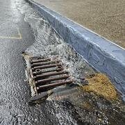
Integrating Stormwater Drainage into USGS StreamStats Application for the Duwamish and Lower Green River
Science and Products
Integrating Stormwater Drainage into USGS StreamStats Application for the Duwamish and Lower Green River
*Disclaimer: Listing outside positions with professional scientific organizations on this Staff Profile are for informational purposes only and do not constitute an endorsement of those professional scientific organizations or their activities by the USGS, Department of the Interior, or U.S. Government