Steaming Mount St. Helens as seen from Interstate 5, at Chehelis, WA.
Steaming Mount St. Helens as seen from Interstate 5, at Chehelis, WA.Steaming Mount St. Helens as seen from Interstate 5, at Chehelis, Washington.

Official websites use .gov
A .gov website belongs to an official government organization in the United States.
Secure .gov websites use HTTPS
A lock () or https:// means you’ve safely connected to the .gov website. Share sensitive information only on official, secure websites.

Steaming Mount St. Helens as seen from Interstate 5, at Chehelis, Washington.
Steaming Mount St. Helens as seen from Interstate 5, at Chehelis, Washington.

On March 20, 1980, after a quiet period of 123 years, earthquake activity once again began under Mount St. Helens volcano. Seven days later, on March 27, small phreatic (steam) explosions began.
On March 20, 1980, after a quiet period of 123 years, earthquake activity once again began under Mount St. Helens volcano. Seven days later, on March 27, small phreatic (steam) explosions began.

Mount St. Helens prior to the catastrophic eruption of May 18, 1980. Streams and lava flows also visible. View is looking southerly from oblique aerial view. Mount Hood in distance.
Mount St. Helens prior to the catastrophic eruption of May 18, 1980. Streams and lava flows also visible. View is looking southerly from oblique aerial view. Mount Hood in distance.

View from the west of the top of Mount St. Helens showing a graben and new crater.
View from the west of the top of Mount St. Helens showing a graben and new crater.

View looking west of Mount St. Helens' summit after several small explosive eruptions. The smaller of the two pit craters was formed first on March 27. Subsequent eruptions opened the farther crater.
View looking west of Mount St. Helens' summit after several small explosive eruptions. The smaller of the two pit craters was formed first on March 27. Subsequent eruptions opened the farther crater.

Ash covered snow is a result of wind direction, resulting in left portion of cone free of ash while the right portion is covered. Snowstorms later covered these ash layers, which in turn were covered by new ash. The result was many alternating layers of snow and ash.
Ash covered snow is a result of wind direction, resulting in left portion of cone free of ash while the right portion is covered. Snowstorms later covered these ash layers, which in turn were covered by new ash. The result was many alternating layers of snow and ash.

View from the northwest of a phreatic eruption on Mount St. Helens pre- May 18, 1980 eruption.
View from the northwest of a phreatic eruption on Mount St. Helens pre- May 18, 1980 eruption.

View from the north of Mount St. Helens' eruption and first crater.
View from the north of Mount St. Helens' eruption and first crater.

An east-west fault across middle of summit area and an uplift or bulge on upper north flank of the volcano are also visible in this photo.
An east-west fault across middle of summit area and an uplift or bulge on upper north flank of the volcano are also visible in this photo.

Although seismic activity began under Mount St. Helens on March 20, this overflight showed no unusual features except numerous tracks of earthquake-triggered snow avalanches. No evidence of fracturing of summit area was detected during careful visual observations on the afternoon of March 24, 1980.
Although seismic activity began under Mount St. Helens on March 20, this overflight showed no unusual features except numerous tracks of earthquake-triggered snow avalanches. No evidence of fracturing of summit area was detected during careful visual observations on the afternoon of March 24, 1980.

Before the devastating May 18, 1980 eruption, Mount St. Helens was considered to be one of the most beautiful and most frequently-climbed peaks in the Cascade Range. Spirit Lake was a vacation area offering hiking, camping, boating, and fishing.
Before the devastating May 18, 1980 eruption, Mount St. Helens was considered to be one of the most beautiful and most frequently-climbed peaks in the Cascade Range. Spirit Lake was a vacation area offering hiking, camping, boating, and fishing.

Summit region (Kalama age–1479 to 1720 C.E.) of Mount St. Helens looking northeast. Spirit Lake and Mount Adams in background. September 28, 1979.
Summit region (Kalama age–1479 to 1720 C.E.) of Mount St. Helens looking northeast. Spirit Lake and Mount Adams in background. September 28, 1979.

Mount St. Helens one year prior to the May 18, 1980, catastrophic eruption, showing glaciers at the summit.
Mount St. Helens one year prior to the May 18, 1980, catastrophic eruption, showing glaciers at the summit.

Before the eruption of May 18, 1980, Mount St. Helens' elevation was 2,950 m (9,677 ft). View from the west, Mount Adams in distance. S. Fork Toutle River is valley in center of photo.
Mount Adams elevation is 3,745 m (12, 286 ft). Mount St. Helens was the smallest of five major volcanic peaks in Washington State.

Worm Complex on the southeast flank of Mount St. Helens—Middle Kalama lava flows in center of image. Photo from September 28, 1979. Click to view larger image.
Worm Complex on the southeast flank of Mount St. Helens—Middle Kalama lava flows in center of image. Photo from September 28, 1979. Click to view larger image.

Studebaker Ridge formed during the Tertiary geologic time period (65 million to 2.6 million years ago). The pyroclastic surge from the May 18, 1980 eruption destroyed the trees on the ridge.
Studebaker Ridge formed during the Tertiary geologic time period (65 million to 2.6 million years ago). The pyroclastic surge from the May 18, 1980 eruption destroyed the trees on the ridge.

Shoestring Glacier on Mount St. Helens, viewed from the southeast. Photo from May, 1965.
Shoestring Glacier on Mount St. Helens, viewed from the southeast. Photo from May, 1965.

Aerial photo of Mount St. Helens taken from the northeast in September 1964.
Aerial photo of Mount St. Helens taken from the northeast in September 1964.
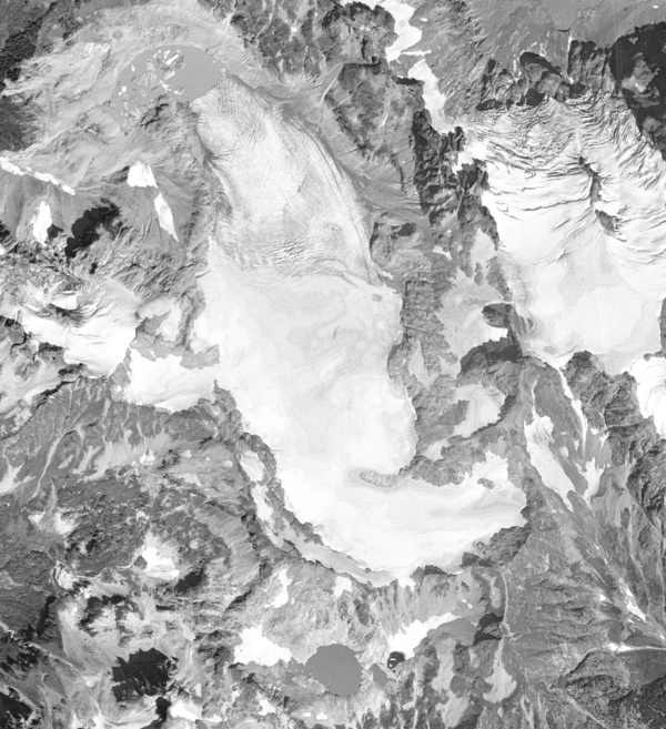
Aerial photograph of South Cascade Glacier, WA taken August 13th, 1958.
Aerial photograph of South Cascade Glacier, WA taken August 13th, 1958.

Hydrologic Technicians use bridge cranes and reels to collect water quality samples. Similar technology is still in use today.
Hydrologic Technicians use bridge cranes and reels to collect water quality samples. Similar technology is still in use today.

A cableway spanning the Columbia River allowed hydrologic technicians to traverse the steep basalt river banks. Pictured before the construction of Priest Rapids Dam, the cableway was located at USGS streamgage 12472800.
A cableway spanning the Columbia River allowed hydrologic technicians to traverse the steep basalt river banks. Pictured before the construction of Priest Rapids Dam, the cableway was located at USGS streamgage 12472800.