U.S. flag

An official website of the United States government

Images

Kīlauea images of eruptive activity, field work, and more.

Filter Total Items: 3089
Color panoramic photograph of lava fountain and lava channel within volcanic crater
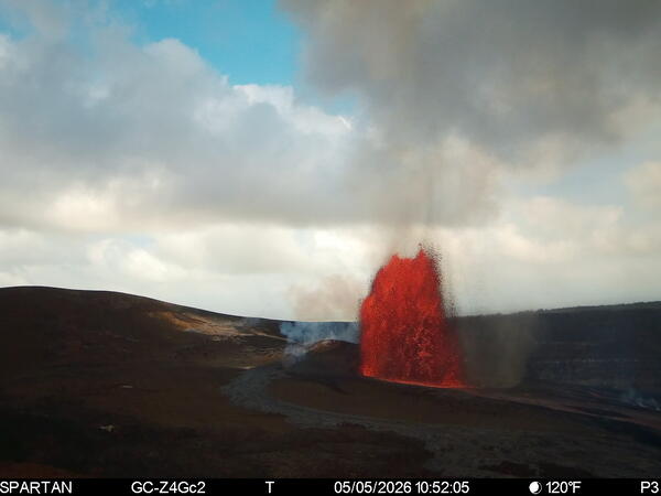
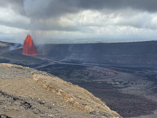
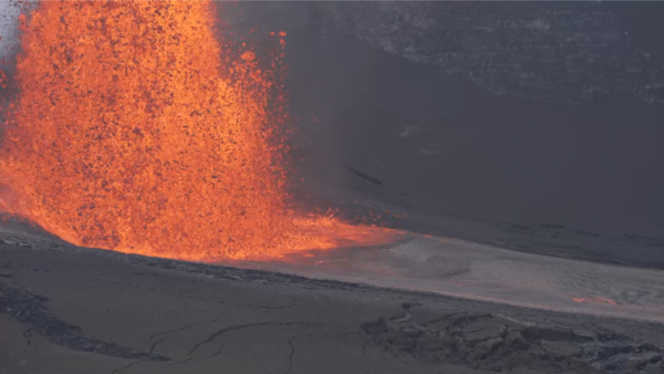
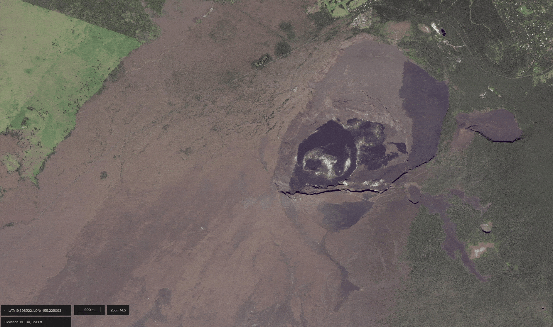
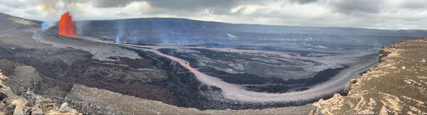
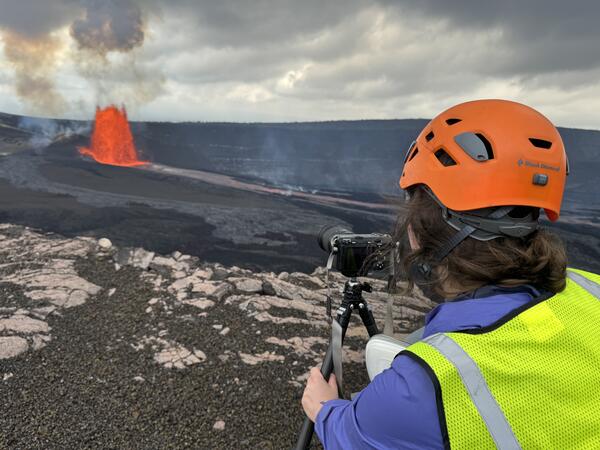
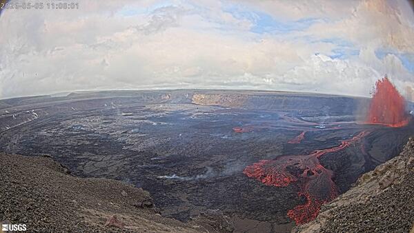
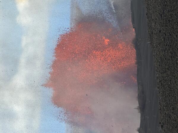
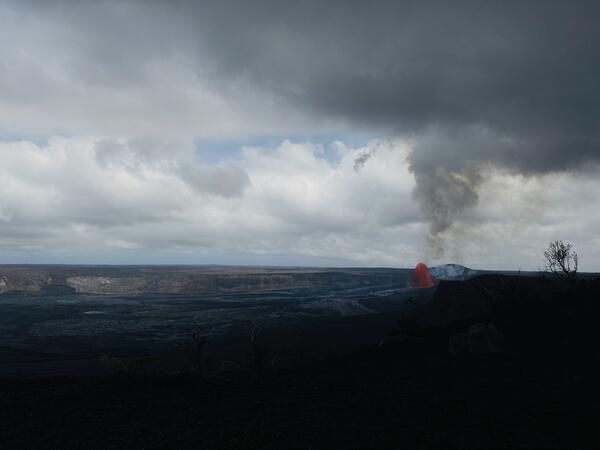
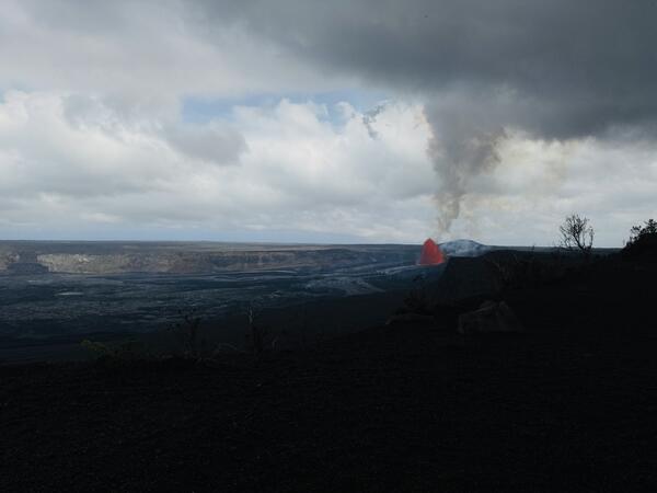
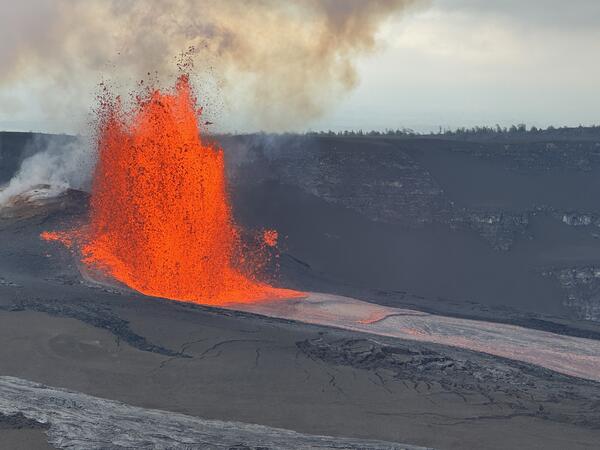
May 5, 2026 — Episode 46 lava fountaining at Kīlauea summit pano

Episode 46 of lava fountaining in Halemaʻumaʻu began at the summit of Kīlauea at 8:17 a.m. HST on May 5th, 2026. This panoramic photograph, taken from the south rim of Halemaʻumaʻu at 1 p.m. HST, shows the lava fountain from the north vent feeding a channelized lava flow across the crater floor. USGS photo by M. Patrick. 

Episode 46 of lava fountaining in Halemaʻumaʻu began at the summit of Kīlauea at 8:17 a.m. HST on May 5th, 2026. This panoramic photograph, taken from the south rim of Halemaʻumaʻu at 1 p.m. HST, shows the lava fountain from the north vent feeding a channelized lava flow across the crater floor. USGS photo by M. Patrick. 

Color photograph showing a volcanic plume rising in the background of a volcanic caldera
May 5, 2026 — Kīlauea episode 46 plume rises above Mauna Loa summit caldera

Just after 10 a.m. on May 5, 2026, the eruption plume from episode 46 of Kīlauea summit lava fountaining was visible in the USGS Hawaiian Volcano Observatory MLcam, located on the north rim of Mokuʻāweoweo (Mauna Loa summit caldera).

Just after 10 a.m. on May 5, 2026, the eruption plume from episode 46 of Kīlauea summit lava fountaining was visible in the USGS Hawaiian Volcano Observatory MLcam, located on the north rim of Mokuʻāweoweo (Mauna Loa summit caldera).

Color photograph of scientist monitoring volcanic eruption
May 5, 2026 — Scientist monitors episode 46 lava fountaining at Kīlauea summit

A USGS Hawaiian Volcano Observatory geologist monitors episode 46 lava fountain in Halemaʻumaʻu at the summit of Kīlauea. From various locations around Kaluapele, Kīlauea summit caldera, USGS scientists check for tephra fallout, document and characterize eruptive activity, and measure the lava fountain and volcanic plume heights. USGS photo by M. Patrick. 

A USGS Hawaiian Volcano Observatory geologist monitors episode 46 lava fountain in Halemaʻumaʻu at the summit of Kīlauea. From various locations around Kaluapele, Kīlauea summit caldera, USGS scientists check for tephra fallout, document and characterize eruptive activity, and measure the lava fountain and volcanic plume heights. USGS photo by M. Patrick. 

Color webcam image showing lava fountaining and lava flows within a volcanic crater
May 5, 2026 — Episode 46 lava fountain and flow from KWcam

This photograph was taken by the KWcam located on the northwest rim of Halemaʻumaʻu crater during episode 46 of lava fountaining at the summit of Kīlauea on May 5, 2026. The episode began at 8:17 a.m.

This photograph was taken by the KWcam located on the northwest rim of Halemaʻumaʻu crater during episode 46 of lava fountaining at the summit of Kīlauea on May 5, 2026. The episode began at 8:17 a.m.

Color photograph of lava fountain during the day time with crater rim in the foreground
May 5, 2026 — Episode 46 north vent lava fountain

From the north rim of Halemaʻumaʻu crater at the summit of Kīlauea, the lava fountain from the north vent rises above the crater rim visible in the foreground. This photograph was taken just after 10 a.m. HST, and cooled, dark-colored tephra particles falling from the lava fountain are visible, illuminated by the incandescent lava fountain the background.

From the north rim of Halemaʻumaʻu crater at the summit of Kīlauea, the lava fountain from the north vent rises above the crater rim visible in the foreground. This photograph was taken just after 10 a.m. HST, and cooled, dark-colored tephra particles falling from the lava fountain are visible, illuminated by the incandescent lava fountain the background.

Color photograph of lava fountain and plume
May 5, 2026 — Episode 46 lava fountain and volcanic plume at Kīlauea summit

During episode 46 of lava fountaining at the summit of Kīlauea, the lava fountain from the north vent reached a maximum of 650 feet (200 meters) above ground level and the volcanic plume reached a maximum height of about 20,000 feet (6,000 meters) above ground level around 10:30 a.m. HST on May 5, 2026. USGS photo by K. Mulliken. 

During episode 46 of lava fountaining at the summit of Kīlauea, the lava fountain from the north vent reached a maximum of 650 feet (200 meters) above ground level and the volcanic plume reached a maximum height of about 20,000 feet (6,000 meters) above ground level around 10:30 a.m. HST on May 5, 2026. USGS photo by K. Mulliken. 

Color photograph of lava fountain within volcanic crater
May 5, 2026 — Episode 46 north vent lava fountaining at Kīlauea summit

During episode 46 at the summit of Kīlauea on May 5, 2026, the north vent erupted lava fountains reaching a maximum height of 650 feet (200 meters) above the vent. This photograph was taken from the north rim of Kaluapele, Kīlauea summit caldera, at approximately 1 p.m. HST. USGS photo by K. Mulliken. 

During episode 46 at the summit of Kīlauea on May 5, 2026, the north vent erupted lava fountains reaching a maximum height of 650 feet (200 meters) above the vent. This photograph was taken from the north rim of Kaluapele, Kīlauea summit caldera, at approximately 1 p.m. HST. USGS photo by K. Mulliken. 

Color photograph of lava fountain and lava channel
May 5, 2026 — Episode 46 north vent lava fountain and channel

The lava fountain from the north vent in Halemaʻumaʻu at the summit of Kīlauea viewed from the south rim at approximately 3 p.m. HST on May 5, 2026. Channelized lava flowing from the north vent fed lava flows on the floor of Halemaʻumaʻu crater. USGS photo by M. Patrick. 

The lava fountain from the north vent in Halemaʻumaʻu at the summit of Kīlauea viewed from the south rim at approximately 3 p.m. HST on May 5, 2026. Channelized lava flowing from the north vent fed lava flows on the floor of Halemaʻumaʻu crater. USGS photo by M. Patrick. 

Color photograph of lava fountain
May 5, 2026 — Kīlauea episode 46 from webcam

This image shows the north vent in Halema‘uma‘u erupting a lava fountain during episode 46 at Kīlauea summit on May 5, 2026. This image was captured by a timelapse camera located on the south rim of the caldera. USGS webcam image. 

This image shows the north vent in Halema‘uma‘u erupting a lava fountain during episode 46 at Kīlauea summit on May 5, 2026. This image was captured by a timelapse camera located on the south rim of the caldera. USGS webcam image. 

Color map showing areas at the summit of a volcano that were affected by fallout during an eruption
May 8, 2026 — Kīlauea lava flow and tephra fall map following episodes 45 and 46

This map shows lava flow and tephra accumulation at the summit of Kīlauea volcano associated with episode 45 and 46 of the ongoing eruption in Halemaʻumaʻu that started on December 23, 2024, using data recorded by the Italian Space Agency's (ASI) COSMO-SkyMed Second Generation satellite constellation.

This map shows lava flow and tephra accumulation at the summit of Kīlauea volcano associated with episode 45 and 46 of the ongoing eruption in Halemaʻumaʻu that started on December 23, 2024, using data recorded by the Italian Space Agency's (ASI) COSMO-SkyMed Second Generation satellite constellation.

Color photograph of lava fountain and volcanic gas jet
May 5, 2026 — Episode 46 north vent lava fountain and south vent gas jet

The north vent (right in photo) in Halemaʻumaʻu erupted a lava fountain during episode 46 at the summit of Kīlauea on May 5, 2026. The south vent (left in photo) spattered intermittently during the first half of episode 46, and gas jetting continued to be visible during the latter half of episode 46. USGS photo by M. Patrick. 

The north vent (right in photo) in Halemaʻumaʻu erupted a lava fountain during episode 46 at the summit of Kīlauea on May 5, 2026. The south vent (left in photo) spattered intermittently during the first half of episode 46, and gas jetting continued to be visible during the latter half of episode 46. USGS photo by M. Patrick. 

Color photograph of lava fountain with broken road in foreground
May 5, 2026 — Episode 46 north vent lava fountain with Crater Rim Drive in the foreground

From the south rim of Halemaʻumaʻu crater, the north vent lava fountain during episode 46 on May 5, 2026, rose above the crater rim. In the foreground, the damaged remains of Crater Rim Drive, which became impassable during the 2018 Kīlauea summit collapse, are littered with tephra fallout from past lava fountaining episodes. USGS photo by M. Patrick. 

From the south rim of Halemaʻumaʻu crater, the north vent lava fountain during episode 46 on May 5, 2026, rose above the crater rim. In the foreground, the damaged remains of Crater Rim Drive, which became impassable during the 2018 Kīlauea summit collapse, are littered with tephra fallout from past lava fountaining episodes. USGS photo by M. Patrick. 

Strands of volcanic glass and ash on the ground with a highlighter for scale
May 5, 2026 — Episode 46 Pele's hair, lapilli, and ash near Kilauea Military Camp

Pele's hair, lapilli, and ash particles from episode 46 of lava fountaining at the summit of Kīlauea were transported by wind in a north-northwest direction during the latter half of the episode on the afternoon of May 5, 2026.

Pele's hair, lapilli, and ash particles from episode 46 of lava fountaining at the summit of Kīlauea were transported by wind in a north-northwest direction during the latter half of the episode on the afternoon of May 5, 2026.

Color photograph of volcanic glass strands with pen cap for scale
May 5, 2026 — Episode 46 Pele's hair

This macro photograph shows Pele's hair, strands of volcanic glass, that had accumulated into a tumble-weed-like structure where it fell at the USGS Hawaiian Volcano Observatory field station near Kilauea Military Camp in Hawaiʻi Volcanoes National Park. A highlighter cap provides a scale. USGS photo by K. Mulliken. 

This macro photograph shows Pele's hair, strands of volcanic glass, that had accumulated into a tumble-weed-like structure where it fell at the USGS Hawaiian Volcano Observatory field station near Kilauea Military Camp in Hawaiʻi Volcanoes National Park. A highlighter cap provides a scale. USGS photo by K. Mulliken. 

Color photograph of lava fountain with crater rim in foreground
May 5, 2026 — Episode 46 north vent lava fountain at Kīlauea summit

Another view of the north vent erupting a lava fountain at the summit of Kīlauea during episode 46 on May 5, 2026. This photograph was taken from the south rim of Halemaʻumaʻu, and part of the crater rim visible in the foreground. Incandescent lava flows on the crater floor are visible emanating downslope of the north vent. USGS photo by M. Patrick. 

Another view of the north vent erupting a lava fountain at the summit of Kīlauea during episode 46 on May 5, 2026. This photograph was taken from the south rim of Halemaʻumaʻu, and part of the crater rim visible in the foreground. Incandescent lava flows on the crater floor are visible emanating downslope of the north vent. USGS photo by M. Patrick. 

Color photograph of lava fountain base and lava channel
May 5, 2026 — North vent lava fountain base and lava channel flowing from vent

This telephoto view shows the base of the north vent lava fountain during episode 46 at the summit of Kīlauea on May 5, 2026. A wide channel of lava flows from the vent, to feed lava flows on the floor of Halemaʻumaʻu crater. USGS photo by M. Patrick. 

This telephoto view shows the base of the north vent lava fountain during episode 46 at the summit of Kīlauea on May 5, 2026. A wide channel of lava flows from the vent, to feed lava flows on the floor of Halemaʻumaʻu crater. USGS photo by M. Patrick. 

Satellite images showing changes to a region of a volcano overtime as a tephra and lava flow deposits grow
Changes to Kīlauea summit over time during episodic lava fountaining eruption

This animated gif showing changes to Kīlauea summit region during the episodic lava fountaining eruption. The first satellite image was taken on November 27, 2024, before the eruption began.

Color collage of five images of different eruptions or lava flow deposits
Photograph collage showing Kīlauea summit eruptions and their features

Photos of the fissure and lava cascading over the caldera rim from the August 14, 1971, eruption (top left), the extensive fissure system from the July 19–22, 1974 eruption (top center), and an aerial photo of the lava flow field from the September 25, 1982, eruption (top right).

Photos of the fissure and lava cascading over the caldera rim from the August 14, 1971, eruption (top left), the extensive fissure system from the July 19–22, 1974 eruption (top center), and an aerial photo of the lava flow field from the September 25, 1982, eruption (top right).

Color compilation pf individual photographs from 45 eruptive episodes with lava fountaining
April 27, 2026 — Photo compilation of episodes 1–45 of the ongoing eruption at the summit of Kīlauea

Photo compilation of episodes 1–45 of the ongoing eruption at the summit of Kīlauea, including webcam imagery and photos taken by USGS Hawaiian Volcano Observatory scientists on the ground and during helicopter overflights. In all photos except for episode 7, the south vent is on the left and the north vent is on the right.

Photo compilation of episodes 1–45 of the ongoing eruption at the summit of Kīlauea, including webcam imagery and photos taken by USGS Hawaiian Volcano Observatory scientists on the ground and during helicopter overflights. In all photos except for episode 7, the south vent is on the left and the north vent is on the right.

Color photograph of scientists on the edge of a volcanic crater with a whirlwind in it
April 23, 2026 — Kīlauea dust devil, or puahiohio

USGS Hawaiian Volcano Observatory geologists conducted post-episode-45 servicing of cameras along the south rim of Kīlauea caldera and witnessed a large dust devil, which is puahiohio in ʻŌlelo Hawaiʻi, driven by heat rising from the hot lava flows on floor of Halema‘uma‘u crater. USGS photo by M. Patrick.

USGS Hawaiian Volcano Observatory geologists conducted post-episode-45 servicing of cameras along the south rim of Kīlauea caldera and witnessed a large dust devil, which is puahiohio in ʻŌlelo Hawaiʻi, driven by heat rising from the hot lava flows on floor of Halema‘uma‘u crater. USGS photo by M. Patrick.

Was this page helpful?