
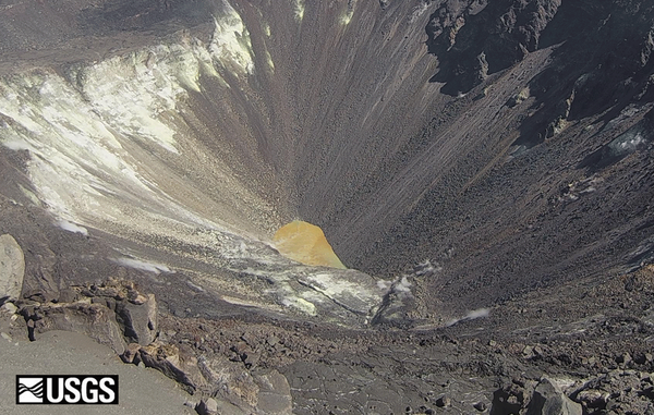
A close-up view of the Kilauea pond shows the color variations across the surface, and sharp boundaries among zones of different color.
Images
Kīlauea images of eruptive activity, field work, and more.
Filter Total Items: 3089

A close-up view of the Kilauea pond
A close-up view of the Kilauea pond shows the color variations across the surface, and sharp boundaries among zones of different color.

HVO scientist tests colorimeter instrument at Kīlauea's summit
HVO scientist tests colorimeter instrument at Kīlauea's summitAn HVO scientist tests a colorimeter instrument on the water lake within Halema‘uma‘u, at Kīlauea's summit. Colorimetry is the measurement of the wavelength and intensity of light. USGS photo by M. Patrick.
Kīlauea summit water lake KW webcam images 11-1-2019 to 10-30-2020
Kīlauea summit water lake KW webcam images 11-1-2019 to 10-30-2020ANNIMATED GIF: This animated image file (GIF) of the Kīlauea summit water lake is a cropped version this file, showing a close-up view of the lake.
Kīlauea summit water lake KW webcam images 11-1-2019 to 10-30-2020
Kīlauea summit water lake KW webcam images 11-1-2019 to 10-30-2020ANNIMATED GIF: This animated image file (GIF) of the Kīlauea summit water lake is a cropped version this file, showing a close-up view of the lake.

Digital elevation model from the 2019 LiDAR survey of Kīlauea
Digital elevation model from the 2019 LiDAR survey of KīlaueaA sample of the digital elevation model from the 2019 LiDAR survey of Kīlauea, showing the vicinity of the former HVO office and Jaggar Museum in Hawaiʻi Volcanoes National Park.
Kīlauea summit water lake KW webcam images 11-1-2019 to 10-30-2020
Kīlauea summit water lake KW webcam images 11-1-2019 to 10-30-2020ANIMATED GIF: The KWcam webcam has been imaging the Kīlauea summit water lake for just over a year now, tracking visual changes in the lake including water level and color.

Halema‘uma‘u water lake at the summit of Kīlauea Volcano
Halema‘uma‘u water lake at the summit of Kīlauea VolcanoThe growing lake of groundwater within Halema‘uma‘u at the summit of Kīlauea Volcano as it looked on December 18, 2019.
Halema‘uma‘u water lake at the summit of Kīlauea Volcano
Halema‘uma‘u water lake at the summit of Kīlauea VolcanoThe growing lake of groundwater within Halema‘uma‘u at the summit of Kīlauea Volcano as it looked on December 18, 2019.

December 18, 2019 thermal image of Kīlauea summit
The December 18 overflight provided updated thermal images of Kīlauea summit, covering the caldera floor and showing the warm surface of the water pond in Halema‘uma‘u crater. A band of warm temperatures persists along the new cliff formed during the 2018 subsidence.
The December 18 overflight provided updated thermal images of Kīlauea summit, covering the caldera floor and showing the warm surface of the water pond in Halema‘uma‘u crater. A band of warm temperatures persists along the new cliff formed during the 2018 subsidence.

December 18, 2019 aerial map of Kīlauea summit
The December 18, 2019, overflight provided updated aerial photographs of Kīlauea summit, covering the caldera floor and showing the current size of the water pond in Halema‘uma‘u crater.
The December 18, 2019, overflight provided updated aerial photographs of Kīlauea summit, covering the caldera floor and showing the current size of the water pond in Halema‘uma‘u crater.

Volcano Awareness Month 2020
Volcano Awareness Month programs offered in January 2020 are depicted by these images. Clockwise from top left: ground cracks opened at HVO's former location atop Kīlauea in 2018; fissure erupting on Mauna Loa in March 1984; crater lake within Halema‘uma‘u at Kīlauea's summit; and visitors hiking a Kahuku trail in Hawai‘i Volcanoes National Park (NPS).
Volcano Awareness Month programs offered in January 2020 are depicted by these images. Clockwise from top left: ground cracks opened at HVO's former location atop Kīlauea in 2018; fissure erupting on Mauna Loa in March 1984; crater lake within Halema‘uma‘u at Kīlauea's summit; and visitors hiking a Kahuku trail in Hawai‘i Volcanoes National Park (NPS).

Continued slow rise of water level at bottom of Halema‘uma‘u, November
Continued slow rise of water level at bottom of Halema‘uma‘u, NovemberPhotos taken two weeks apart show the rise of water in Halema‘uma‘u. A white arrow denotes a large rock along the edge of the lake for comparing water levels in the two images. The water continues to rise at a rate of approximately 15 cm (6 in) per day. USGS photos by M. Patrick.

Water collected from the lake at the bottom of Halema‘uma‘u
Water collected from the lake at the bottom of Halema‘uma‘uWater collected from the lake at the bottom of Halema‘uma‘u is prepared for laboratory analyses at the USGS California Volcano Observatory. Results thus far reveal chemistry indicative of complex reactions among the water, magmatic gases and Kīlauea's basaltic rocks.

Water collected from the lake at the bottom of Halema‘uma‘u
Water collected from the lake at the bottom of Halema‘uma‘uWater collected from the lake at the bottom of Halema‘uma‘u is prepared for laboratory analyses at the USGS California Volcano Observatory. Results thus far reveal chemistry indicative of complex reactions between the water, magmatic gases, and Kīlauea's basaltic rocks.

Unoccupied Aircraft System is inspected by pilot just before take off
Unoccupied Aircraft System is inspected by pilot just before take offThe sampling mechanism (on blue tarp) is prepared and the Unoccupied Aircraft System (UAS) is inspected just before take off to collect water from the Halema‘uma‘u crater lake. Brightly colored flagging tape tied to a cable attached to the UAS indicated depth as the sampling tool was lowered into the water.

Unoccupied Aircraft System returning with a water sample.
Unoccupied Aircraft System returning with a water sample.USGS-HVO scientists and DOI UAS team members collect samples of water from the Halema‘uma‘u crater lake.
Unoccupied Aircraft System returning with a water sample.
Unoccupied Aircraft System returning with a water sample.USGS-HVO scientists and DOI UAS team members collect samples of water from the Halema‘uma‘u crater lake.

HVO scientists prepare UAS for Kīlauea summit crater lake sampling
HVO scientists prepare UAS for Kīlauea summit crater lake samplingUSGS Hawaiian Volcano Observatory and DOI Office of Aviation staff prepare the sampling mechanism (on blue tarp) and inspect the Unmanned Aircraft System (UAS) just before it took off to collect water from the Halema‘uma‘u crater lake.

Geophysicist Sarah Conway, USGS HVO geophysicist
Geophysicist Sarah Conway, a member of the USGS Hawaiian Volcano Observatory's deformation team, readies a temporary GPS station during a campaign survey of benchmarks on Kīlauea Volcano to monitor changes in the ground surface.
Geophysicist Sarah Conway, a member of the USGS Hawaiian Volcano Observatory's deformation team, readies a temporary GPS station during a campaign survey of benchmarks on Kīlauea Volcano to monitor changes in the ground surface.

Water pond in Halema‘uma‘u 8-18-19
Water pond in Halema‘uma‘u August 18, 2019. The water level continues to slowly rise in Halema‘uma‘u, drowning many of the small rocks that were previously exposed in the center of the pond. Ripples across the water surface were evident today.
Water pond in Halema‘uma‘u August 18, 2019. The water level continues to slowly rise in Halema‘uma‘u, drowning many of the small rocks that were previously exposed in the center of the pond. Ripples across the water surface were evident today.

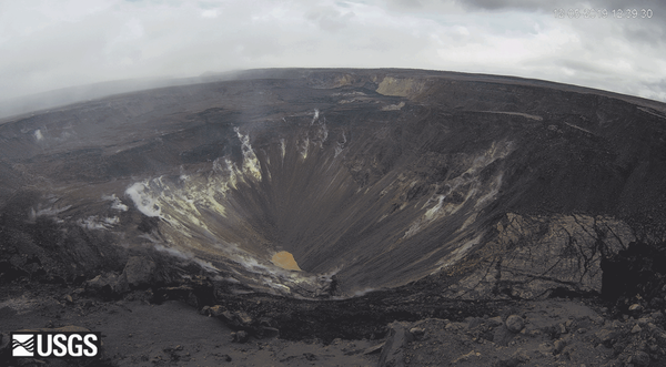
Aerial view of the Halema‘uma‘u water pond
The ponded water at the bottom of Halema‘uma‘u has continued to slowly rise. This wide view shows much of Halema‘uma‘u and the fumaroles on the upper walls of the pit.
The ponded water at the bottom of Halema‘uma‘u has continued to slowly rise. This wide view shows much of Halema‘uma‘u and the fumaroles on the upper walls of the pit.

What does water in Halema‘uma‘u mean
These images look east at the pond within Halema‘uma‘u on August 8 and 14, 2019. The pond widened mainly toward the south (right). The north-south width of the pond on August 14 was about 32 m (105 ft), about 10 m (35 ft) wider than on August 8. The pond has widened and deepened slowly and steadily rate since measurements began on August 3.
These images look east at the pond within Halema‘uma‘u on August 8 and 14, 2019. The pond widened mainly toward the south (right). The north-south width of the pond on August 14 was about 32 m (105 ft), about 10 m (35 ft) wider than on August 8. The pond has widened and deepened slowly and steadily rate since measurements began on August 3.

Two HVO geologists document road cutting activities on HWY 132
Two HVO geologists document road cutting activities on HWY 132Two HVO geologists document road cutting activities on HWY 132 on August 7, 2019. One geologist is taking visual photographs while another geologist is taking thermal photographs to make a tandem pair for comparison. The temperature of the solidified lava was measured to 425° C (800° F) at the digging site.

HVO now tracking ponds of water, not lava, at Kīlauea's summit
HVO now tracking ponds of water, not lava, at Kīlauea's summitA telephoto view of the ponded water at the bottom of Halema‘uma‘u on August 7, 2019. For scale, the largest pond is about 15 meters (50 feet) in diameter.
HVO now tracking ponds of water, not lava, at Kīlauea's summit
HVO now tracking ponds of water, not lava, at Kīlauea's summitA telephoto view of the ponded water at the bottom of Halema‘uma‘u on August 7, 2019. For scale, the largest pond is about 15 meters (50 feet) in diameter.