
Lava from fissure 8 advances on Kahukai Street. Lava in this area is as much as 3.5 yards in height.
Images
Kīlauea images of eruptive activity, field work, and more.
Filter Total Items: 3089

Kīlauea Volcano — Lava on Kahukai Street
Lava from fissure 8 advances on Kahukai Street. Lava in this area is as much as 3.5 yards in height.

Halema‘uma‘u at the summit of Kīlauea Volcano captured from an Unmanne
Halema‘uma‘u at the summit of Kīlauea Volcano captured from an UnmanneAn aerial view of Halema‘uma‘u at the summit of Kīlauea Volcano captured from an Unmanned Aircraft Systems (UAS) overflight video on May 31, 2018. Limited UAS flights into this hazardous area are conducted with permission and coordination with Hawai‘i Volcanoes National Park to collect visual information on this changing eruption site.

Kīlauea Volcano — Fissure 18 Lava Flow
Lava from fissure 18 travels to the southeast (lower left of photo). The flow front that had approached the ocean yesterday has stalled. This view is looking uprift, with fissure 8 in the distance (upper right of photo).
Lava from fissure 18 travels to the southeast (lower left of photo). The flow front that had approached the ocean yesterday has stalled. This view is looking uprift, with fissure 8 in the distance (upper right of photo).

Kīlauea Volcano — Early Morning Fissure 8 Activity
Kīlauea Volcano — Early Morning Fissure 8 ActivityCrews make visual observations of activity at fissure 8 around 5:30 a.m. HST. Fountain heights this morning continue to reach 70 to 80 m (230 to 260 ft) above ground level.
Kīlauea Volcano — Early Morning Fissure 8 Activity
Kīlauea Volcano — Early Morning Fissure 8 ActivityCrews make visual observations of activity at fissure 8 around 5:30 a.m. HST. Fountain heights this morning continue to reach 70 to 80 m (230 to 260 ft) above ground level.

Kīlauea LERZ Fissures and Flows, May 31, 2:00 p.m.
Kīlauea LERZ Fissures and Flows, May 31, 2:00 p.m.Map as of 2:00 p.m. HST, May 31, 2018. Given the dynamic nature of Kīlauea's lower East Rift Zone eruption, with changing vent locations, fissures starting and stopping, and varying rates of lava effusion, map details shown here are accurate as of the date/time noted. Shaded purple areas indicate lava flows erupted in 1840, 1955, 1960, and 2014-2015.

Kīlauea Volcano — Advancing Lobes from Fissure 8
Helicopter overflight shows advancing lobes from fissure 8 (fissure 8 is not pictured but located to the right, out of view). Advance rates were less than 100 yards per hour for the three lobes of the flow, as measured during the overnight hours.
Helicopter overflight shows advancing lobes from fissure 8 (fissure 8 is not pictured but located to the right, out of view). Advance rates were less than 100 yards per hour for the three lobes of the flow, as measured during the overnight hours.

Kīlauea LERZ Fissures and Flows, May 31, 9:00 a.m.
Kīlauea LERZ Fissures and Flows, May 31, 9:00 a.m.Map as of 9:00 a.m. HST, May 31, 2018. Given the dynamic nature of Kīlauea lower East Rift Zone eruption, with changing vent locations, fissures starting and stopping, and varying rates of lava effusion, map details shown here are accurate as of the date/time noted. Shaded purple areas indicate lava flows erupted in 1840, 1955, 1960, and 2014-2015.

Kīlauea LERZ Fissures and Flows, May 30, 9:00 a.m.
Kīlauea LERZ Fissures and Flows, May 30, 9:00 a.m.Map as of 9:00 a.m. HST, May 30, 2018. Given the dynamic nature of Kīlauea's lower East Rift Zone eruption, with changing vent locations, fissures starting and stopping, and varying rates of lava effusion, map details shown here are accurate as of the date/time noted—and could have changed rapidly since that time.

Kīlauea summit activity
Views Kīlauea's summit were often obscured by fog and rain today, but a break in the weather around 2:00 p.m. HST allowed HVO's webcam to capture this image of the gas and steam plume being emitted from Halema‘uma‘u.
Views Kīlauea's summit were often obscured by fog and rain today, but a break in the weather around 2:00 p.m. HST allowed HVO's webcam to capture this image of the gas and steam plume being emitted from Halema‘uma‘u.

Kīlauea LERZ Fissures and Flows, May 30, 3:00 p.m.
Kīlauea LERZ Fissures and Flows, May 30, 3:00 p.m.Map as of 3:00 p.m. HST, May 30, 2018. Given the dynamic nature of Kīlauea's lower East Rift Zone eruption, with changing vent locations, fissures starting and stopping, and varying rates of lava effusion, map details shown here are accurate as of the date/time noted. Shaded purple areas indicate lava flows erupted in 1840, 1955, 1960, and 2014-2015.

Kīlauea Volcano —

Kīlauea Volcano — Summit Plume
Views Kīlauea's summit were often obscured by fog and rain today, but a break in the weather around 2:00 p.m. HST allowed HVO's webcam to capture this image of the gas and steam plume being emitted from Halema‘uma‘u.
Views Kīlauea's summit were often obscured by fog and rain today, but a break in the weather around 2:00 p.m. HST allowed HVO's webcam to capture this image of the gas and steam plume being emitted from Halema‘uma‘u.

Kīlauea Volcano —
Fissure 8 reactivated on the afternoon of May 28, when, at times, lava fountains were reaching heights of 200 feet and feeding a lava flow&
Fissure 8 reactivated on the afternoon of May 28, when, at times, lava fountains were reaching heights of 200 feet and feeding a lava flow&

Kīlauea Volcano — Weak Ocean Entry
Scientists on the early morning overflight of Kīlauea Volcano's lower East Rift Zone documented a very weak ocean entry. For the easternmost lobe, only a few small finger channels of lava were entering the ocean.
Scientists on the early morning overflight of Kīlauea Volcano's lower East Rift Zone documented a very weak ocean entry. For the easternmost lobe, only a few small finger channels of lava were entering the ocean.

Kīlauea Volcano — Tephra on Leilani Street
Tephra (airborne lava fragments) erupted by the high lava fountains of fissure 8 was carried downwind, where the frothy rock fragments fell on Leilani Street, just past Kupono Street, in the Leilani Estates subdivision.
Tephra (airborne lava fragments) erupted by the high lava fountains of fissure 8 was carried downwind, where the frothy rock fragments fell on Leilani Street, just past Kupono Street, in the Leilani Estates subdivision.
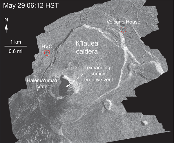
Kīlauea Volcano — Animation of Summit Enlargement
This animated GIF shows a sequence of radar amplitude images that were acquired by the Italian Space Agency's Cosmo-SkyMed satellite system. The series shows changes to the caldera area of Kīlauea Volcano that occurred over May 5 at 6:12 a.m. HST, May 17 at 6:12 a.m.
This animated GIF shows a sequence of radar amplitude images that were acquired by the Italian Space Agency's Cosmo-SkyMed satellite system. The series shows changes to the caldera area of Kīlauea Volcano that occurred over May 5 at 6:12 a.m. HST, May 17 at 6:12 a.m.

Overflight confirms weak ocean entry, in Kīlauea's LERZ
Overflight confirms weak ocean entry, in Kīlauea's LERZScientists on the early morning overflight of Kīlauea Volcano's lower East Rift Zone documented a very weak ocean entry. For the easternmost lobe, only a few small finger channels of lava were entering the ocean.

Kīlauea LERZ Fissures and Flows, May 29, 6:00 p.m.
Kīlauea LERZ Fissures and Flows, May 29, 6:00 p.m.Map as of 6:00 p.m. HST, May 29, 2018. Given the dynamic nature of Kīlauea's lower East Rift Zone eruption, with changing vent locations, fissures starting and stopping, and varying rates of lava effusion, map details shown here are accurate as of the date/time noted—and could have changed rapidly since that time.

Kīlauea Volcano — Lava Flow Crossing Pohoiki Road
Aerial view of active lava flow crossing Pohoiki Road during an overflight this morning about 7 a.m. HST. Pohoiki Road cuts through middle of photograph.
Aerial view of active lava flow crossing Pohoiki Road during an overflight this morning about 7 a.m. HST. Pohoiki Road cuts through middle of photograph.

Kīlauea Volcano — Fissure Complex
View of the fissurecomplex is toward the southeast during this afternoon's overflight of the lower East Rift Zone at about 1:15 p.m. HST. The lava channel in middle of photograph is filling with lava erupted from fissure 22.
View of the fissurecomplex is toward the southeast during this afternoon's overflight of the lower East Rift Zone at about 1:15 p.m. HST. The lava channel in middle of photograph is filling with lava erupted from fissure 22.

Kīlauea Volcano — Lava Channel and Fountains
Close view of lava channel in middle of the lava flow erupting from fissure 8 during this morning's overflight at about 7 a.m. HST. The tallest lava fountain is fissure 8, active since yesterday evening. The eruption rate at fissure 8 diminished significantly later in the morning.
Close view of lava channel in middle of the lava flow erupting from fissure 8 during this morning's overflight at about 7 a.m. HST. The tallest lava fountain is fissure 8, active since yesterday evening. The eruption rate at fissure 8 diminished significantly later in the morning.