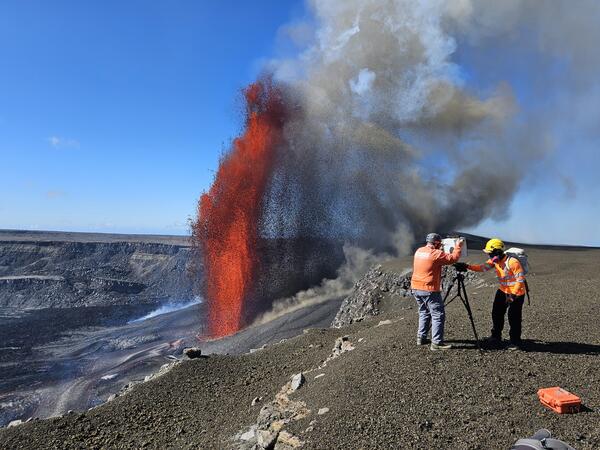
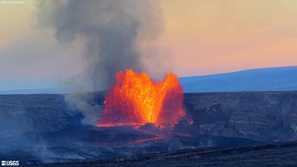
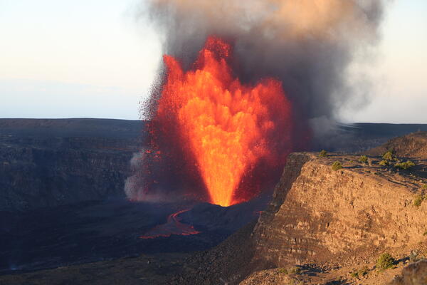
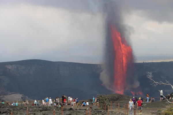
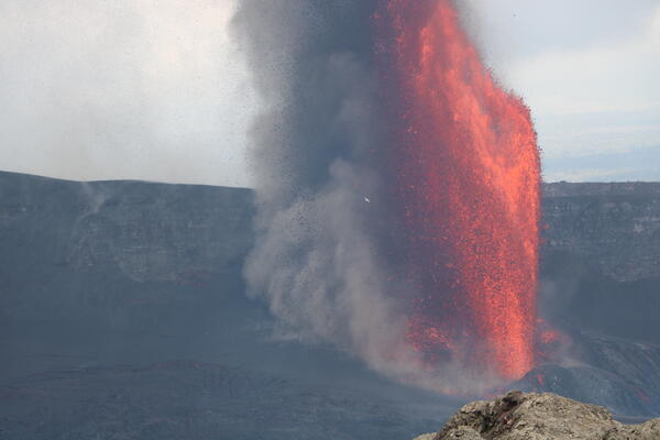
U.S. flag

An official website of the United States government

Images

Kīlauea images of eruptive activity, field work, and more.

Filter Total Items: 2915
Color photograph of crater floor and degassing volcanic vents
April 29, 2025 — Overview of western Halema‘uma‘u

This overview photo of western Halema‘uma‘u crater was captured during a USGS Hawaiian Volcano Observatory monitoring helicopter overflight on Tuesday, April 29.

This overview photo of western Halema‘uma‘u crater was captured during a USGS Hawaiian Volcano Observatory monitoring helicopter overflight on Tuesday, April 29.

Color photograph of degassing volcanic vents
April 29, 2025 — Lava visible within both north and south vents between eruptive episodes at Kīlauea volcano

On April 29, the USGS Hawaiian Volcano Observatory undertook a helicopter surveillance flight over Halema‘uma‘u at the summit of Kīlauea volcano. At the time, the ongoing eruption was between eruptive episodes (episode 18 ended on April 22).

Color photograph of volcanic vent degassing and with a minor amount of incandescent lava visible within
April 29, 2025 — View of lava within north vent between eruptive episodes at Kīlauea volcano

On April 29, the USGS Hawaiian Volcano Observatory undertook a helicopter surveillance flight over Halema‘uma‘u at the summit of Kīlauea volcano. At the time, the ongoing eruption was between eruptive episodes (episode 18 ended on April 22). In this photo looking down towards the east, lava is seen within north vent.

On April 29, the USGS Hawaiian Volcano Observatory undertook a helicopter surveillance flight over Halema‘uma‘u at the summit of Kīlauea volcano. At the time, the ongoing eruption was between eruptive episodes (episode 18 ended on April 22). In this photo looking down towards the east, lava is seen within north vent.

Color photograph of a caldera with an actively degassing vent near one wall
April 29, 2025 — Kīlauea summit overview

A USGS Hawaiian Volcano Observatory monitoring helicopter overflight midday on April 29, 2025, provided views Halema‘uma‘u during a pause in eruptive activity at Kīlauea. In this view looking south, the degassing north and south vents are visible in the center right of the photo.

A USGS Hawaiian Volcano Observatory monitoring helicopter overflight midday on April 29, 2025, provided views Halema‘uma‘u during a pause in eruptive activity at Kīlauea. In this view looking south, the degassing north and south vents are visible in the center right of the photo.

Color photograph of degassing vent with a tiny amount of incandescent lava visible within it
April 29, 2025 — View of lava within north vent at Kīlauea volcano

On April 29, the USGS Hawaiian Volcano Observatory undertook a helicopter surveillance flight over Halema‘uma‘u at the summit of Kīlauea volcano. At the time, the ongoing eruption was between eruptive episodes (episode 18 ended on April 22). In this photo looking down towards the east, lava is seen within north vent.

On April 29, the USGS Hawaiian Volcano Observatory undertook a helicopter surveillance flight over Halema‘uma‘u at the summit of Kīlauea volcano. At the time, the ongoing eruption was between eruptive episodes (episode 18 ended on April 22). In this photo looking down towards the east, lava is seen within north vent.

Color photograph of deposit of ejecta material from a volcanic eruption on the rim of a caldera
April 29, 2025 — Aerial view of tephra blanket from ongoing eruption at Kīlauea

View looking southwest of the southwest corner of Halema‘uma‘u and the tephra blanket from the ongoing eruption at Kīlauea. The tephra is brown and covers center and right side of the photo.

Color photograph of volcanic crater and cone
April 29, 2025 — View of Kīlauea Iki and Pu‘upua‘i

This photograph, taken during a USGS Hawaiian Volcano Observatory monitoring helicopter overflight midday on April 29, 2025, shows an overview of Kīlauea Iki (center) and Pu‘upua‘i (bottom center to right). Kīlauea Iki erupted in 1959 over a 5-week period with 17 fountaining episodes, similar to the ongoing eruption in Halema‘uma‘u.

This photograph, taken during a USGS Hawaiian Volcano Observatory monitoring helicopter overflight midday on April 29, 2025, shows an overview of Kīlauea Iki (center) and Pu‘upua‘i (bottom center to right). Kīlauea Iki erupted in 1959 over a 5-week period with 17 fountaining episodes, similar to the ongoing eruption in Halema‘uma‘u.

Color photograph of volcanic crater
April 25, 2025 — View of Kaluapele from the southeast

During the course of routine monitoring equipment maintenance, on Friday, April 25 a Hawaiian Volcano Observatory geologist visited a site on the southeastern rim of Kaluapele (Kīlauea summit caldera) known as Akanikōlea—a culturally-significant place that is featured in Hawaiian oral traditions.

During the course of routine monitoring equipment maintenance, on Friday, April 25 a Hawaiian Volcano Observatory geologist visited a site on the southeastern rim of Kaluapele (Kīlauea summit caldera) known as Akanikōlea—a culturally-significant place that is featured in Hawaiian oral traditions.

Color photograph of degassing volcanic vents
April 25, 2025 — Kīlauea summit eruption vents degassing

This photo shows south (center) and north (right) vents degassing, three days after the end of episode 18 of Kīlauea's ongoing summit eruption. Mauna Loa's flank is visible in the upper portion of the photo. The tephra blanket (brown) from recent episodes is visible on the wall behind the vents and also draping over the ground at the top of the cliff.

This photo shows south (center) and north (right) vents degassing, three days after the end of episode 18 of Kīlauea's ongoing summit eruption. Mauna Loa's flank is visible in the upper portion of the photo. The tephra blanket (brown) from recent episodes is visible on the wall behind the vents and also draping over the ground at the top of the cliff.

Color photograph of gassy vent
April 23, 2025 — Steamy view of vents a day after episode 18 at Kīlauea's summit

View of north and south vents from the northwest, approximately 21 hours after the end of episode 18 of the eruption at Kīlauea's summit. Volcanic gases, mostly water vapor, obscure most of the view as the wind blows the gas northwards. USGS photo by N. Deligne. 

View of north and south vents from the northwest, approximately 21 hours after the end of episode 18 of the eruption at Kīlauea's summit. Volcanic gases, mostly water vapor, obscure most of the view as the wind blows the gas northwards. USGS photo by N. Deligne. 

Color photograph of material on gated road
April 23, 2025 — Tephra fall covering road near Uēkahuna at Kīlauea's summit

Episode 18 on April 22, 2025, of Kīlauea's ongoing eruption occurred during wind conditions that resulted in tephra being deposited in the Uēkahuna area, north of the vents. Hawai‘i Volcanoes National Park temporarily closed the Uēkahuna area at the time and cleaned affected roads and parking lots after episode 18 ended (foreground).

Episode 18 on April 22, 2025, of Kīlauea's ongoing eruption occurred during wind conditions that resulted in tephra being deposited in the Uēkahuna area, north of the vents. Hawai‘i Volcanoes National Park temporarily closed the Uēkahuna area at the time and cleaned affected roads and parking lots after episode 18 ended (foreground).

Color photograph of erupting lava fountain
April 22, 2025 — Episode 18 lava fountaining at Kīlauea summit

Dawn timelapse image showing the shadow of the episode 18 lava fountain in Halemaʻumaʻu on the west caldera wall at the summit of Kīlauea. USGS photo by M. Patrick.   

Dawn timelapse image showing the shadow of the episode 18 lava fountain in Halemaʻumaʻu on the west caldera wall at the summit of Kīlauea. USGS photo by M. Patrick.   

Color photo of lava fountain and stream leaving volcanic vent
April 22, 2025 — Kīlauea summit eruption episode 18

This photo shows a close up of the south vent at the summit of Kīlauea during episode 18.  USGS photo by M. Patrick. 

Color photograph of eruptive vent
April 22, 2025 — Kīlauea summit eruption episode 18

This photo shows a close up of the north vent at the summit of Kīlauea during episode 18 of the ongoing eruption.  Low fountaining supplied lava to a lava pond that was continuously overflowing the rim of the cone, creating swiftly moving cascades of lava down the flank of the cone.  USGS photo by M. Patrick. 

This photo shows a close up of the north vent at the summit of Kīlauea during episode 18 of the ongoing eruption.  Low fountaining supplied lava to a lava pond that was continuously overflowing the rim of the cone, creating swiftly moving cascades of lava down the flank of the cone.  USGS photo by M. Patrick. 

Color photograph of lava flowing
April 20, 2025 — Intermittent eruptive activity at Kīlauea

A closer view of the ephemeral lava channel active the morning of April 20, supplied by lava from the intermittent activity at the south vent at Kīlauea summit. USGS photo by M. Patrick.


A closer view of the ephemeral lava channel active the morning of April 20, supplied by lava from the intermittent activity at the south vent at Kīlauea summit. USGS photo by M. Patrick.


Color photograph of road
April 20, 2025 — Crater Rim Drive covered with tephra

USGS Hawaiian Volcano Observatory geologists accessed the caldera rim on April 20 by driving on Crater Rim Drive in the hazardous closed area of Hawai‘i Volcanoes National Park. This area, which is generally downwind of the eruptive vents, has now been covered by 2 meters (yards) of tephra from the recent lava fountaining.

USGS Hawaiian Volcano Observatory geologists accessed the caldera rim on April 20 by driving on Crater Rim Drive in the hazardous closed area of Hawai‘i Volcanoes National Park. This area, which is generally downwind of the eruptive vents, has now been covered by 2 meters (yards) of tephra from the recent lava fountaining.

Color photograph of volcanic vent and bird
April 20, 2025 — Kīlauea and Koa‘e Kea

A koa‘e kea (white tailed tropicbird) soars above Halema‘uma‘u crater floor in front of low fountaining at the south vent on April 20. USGS photo by M. Patrick.


A koa‘e kea (white tailed tropicbird) soars above Halema‘uma‘u crater floor in front of low fountaining at the south vent on April 20. USGS photo by M. Patrick.


Color photograph of lava erupting from vent
April 20, 2025 — Intermittent, minor vent activity at Kīlauea

Minor vent activity the morning of April 20 around 8 a.m. HST produced a small flow on Halema‘uma‘u crater floor and an intermittent dome fountain. The low fountain and spattering at the vent often showed a cycle of 3-4 minutes, with lava rising and falling in the conduit at that timescale. The activity was off and on into the early afternoon. USGS photo by M.

Minor vent activity the morning of April 20 around 8 a.m. HST produced a small flow on Halema‘uma‘u crater floor and an intermittent dome fountain. The low fountain and spattering at the vent often showed a cycle of 3-4 minutes, with lava rising and falling in the conduit at that timescale. The activity was off and on into the early afternoon. USGS photo by M.

Color photograph of volcanic vents erupting within crater
April 20, 2025 — Kīlauea eruptive activity

The low dome fountain at the south vent o April 20 was supplying lava to a flow that was approximately 500 meters (550 yards) long. The tip of the lava flow was pouring into the depression formed by the drained lava pond from episode 17. USGS photo by M. Patrick.


The low dome fountain at the south vent o April 20 was supplying lava to a flow that was approximately 500 meters (550 yards) long. The tip of the lava flow was pouring into the depression formed by the drained lava pond from episode 17. USGS photo by M. Patrick.


Color photograph of lava within a volcanic vent
April 18, 2025 — UAS close-up of south vent spatter

During UAS (uncrewed aircraft systems) overflights on April 18, USGS Hawaiian Volcano Observatory geologists flew their aircraft directly above the south vent within Halemaʻumaʻu at the summit of Kīlauea for a close-up view into its depths.

During UAS (uncrewed aircraft systems) overflights on April 18, USGS Hawaiian Volcano Observatory geologists flew their aircraft directly above the south vent within Halemaʻumaʻu at the summit of Kīlauea for a close-up view into its depths.

Color photograph of inactive volcanic vent
April 18, 2025 — UAS aerial view of north vent

During UAS (uncrewed aircraft systems) overflights on April 18, the north vent within Halemaʻumaʻu at the summit of Kīlauea was vigorously degassing although it did not host any obvious active lava. This high-angle aerial photo shows multiple openings in the base of the vent cone that glowed hot in simultaneously captured thermal images.

During UAS (uncrewed aircraft systems) overflights on April 18, the north vent within Halemaʻumaʻu at the summit of Kīlauea was vigorously degassing although it did not host any obvious active lava. This high-angle aerial photo shows multiple openings in the base of the vent cone that glowed hot in simultaneously captured thermal images.

Was this page helpful?