
As episode 14 lava fountaining occurred during the ongoing Kīlauea summit eruption, the KWcam webcam, F1cam thermal camera and continuous laser rangefinder perched on the crater edge (upper right portion of the photo), provided a continuous record of activity.
Images
Kīlauea images of eruptive activity, field work, and more.
Filter Total Items: 3036

Vigorous fountaining during episode 14
As episode 14 lava fountaining occurred during the ongoing Kīlauea summit eruption, the KWcam webcam, F1cam thermal camera and continuous laser rangefinder perched on the crater edge (upper right portion of the photo), provided a continuous record of activity.

Vigorous fountaining during episode 14
Vigorous fountaining began around 6:30 a.m. on March 20, and continued into the early afternoon, as part of episode 14 of the ongoing summit eruption of Kīlauea. In this view from the northeast rim of Kaluapele (the summit caldera), the fountains produce a high outgassing plume, with Mauna Loa on the right side of the photo. USGS photo by M. Patrick.
Vigorous fountaining began around 6:30 a.m. on March 20, and continued into the early afternoon, as part of episode 14 of the ongoing summit eruption of Kīlauea. In this view from the northeast rim of Kaluapele (the summit caldera), the fountains produce a high outgassing plume, with Mauna Loa on the right side of the photo. USGS photo by M. Patrick.

Vigorous fountaining during episode 14
A telephoto view looking at the top of a lava fountain from episode 14 of the ongoing Halema‘uma‘u eruption. A trio of Koa‘e kea (white-tailed tropicbirds) were flying circles close to the lava fountain, at the summit of Kīlauea, presumably riding the thermal updrafts around the vent. USGS photo by M. Patrick taken on March 20, 2025.
A telephoto view looking at the top of a lava fountain from episode 14 of the ongoing Halema‘uma‘u eruption. A trio of Koa‘e kea (white-tailed tropicbirds) were flying circles close to the lava fountain, at the summit of Kīlauea, presumably riding the thermal updrafts around the vent. USGS photo by M. Patrick taken on March 20, 2025.

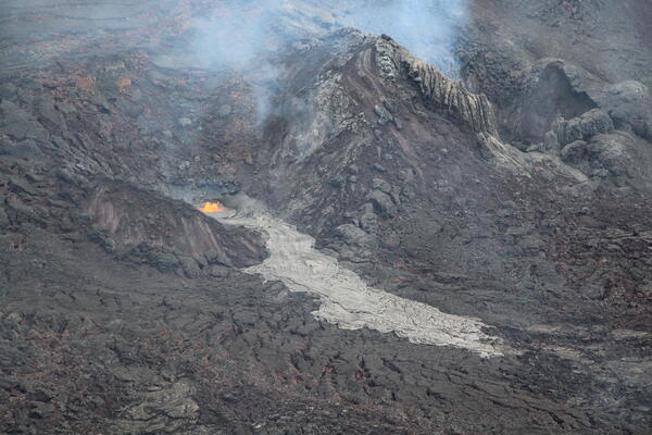
March 19, 2025 — Lava drainback in north vent
Once the northern eruptive vent within Halemaʻumaʻu crater at the summit of Kīlauea became active on March 19, it began exhibiting cyclic dome fountaining and lava drainback approximately every 5 minutes. In this image captured from above on the western crater rim, the drainback is evidenced by whirlpool textures in the lava pond's crustal plates. USGS photo by M.
Once the northern eruptive vent within Halemaʻumaʻu crater at the summit of Kīlauea became active on March 19, it began exhibiting cyclic dome fountaining and lava drainback approximately every 5 minutes. In this image captured from above on the western crater rim, the drainback is evidenced by whirlpool textures in the lava pond's crustal plates. USGS photo by M.

March 19, 2025 — Lava flows in western Halemaʻumaʻu
March 19, 2025 — Lava flows in western HalemaʻumaʻuLater in the morning on March 19, the northern eruptive vent joined its southern counterpart in effusing a lava flow onto the western floor of Halemaʻumaʻu crater at the summit of Kīlauea. Here, both vents and lava flows are seen from above on the western crater rim. USGS photo by M. Zoeller.

March 19, 2025 — Low dome fountain in north vent
A closer view of the low dome fountain at the northern eruptive vent within Halemaʻumaʻu crater at the summit of Kīlauea on March 19, 2025. USGS photo by M. Patrick.
A closer view of the low dome fountain at the northern eruptive vent within Halemaʻumaʻu crater at the summit of Kīlauea on March 19, 2025. USGS photo by M. Patrick.
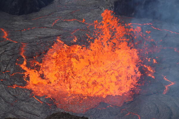
March 19, 2025 — Gas jetting in north vent
At the summit of Kīlauea on March 19, 2025, the onset of draining at the northern eruptive vent within Halemaʻumaʻu crater included intense gas jetting, spraying small droplets of lava vertically. USGS photo by M. Patrick.
At the summit of Kīlauea on March 19, 2025, the onset of draining at the northern eruptive vent within Halemaʻumaʻu crater included intense gas jetting, spraying small droplets of lava vertically. USGS photo by M. Patrick.
March 19, 2025 — Lava flow from south vent
Early on March 19, the southern eruptive vent within Halemaʻumaʻu crater at the summit of Kīlauea was the primary host of low-level eruptive activity. This photo, captured from the southern crater rim, shows minor spatter at the vent and a small lava flow proceeding onto the crater floor. USGS photo by M. Zoeller.
Early on March 19, the southern eruptive vent within Halemaʻumaʻu crater at the summit of Kīlauea was the primary host of low-level eruptive activity. This photo, captured from the southern crater rim, shows minor spatter at the vent and a small lava flow proceeding onto the crater floor. USGS photo by M. Zoeller.
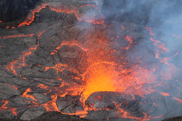
March 19, 2025 — Spattering in north vent
At the summit of Kīlauea on March 19, 2025, cycles of filling and draining at the northern eruptive vent within Halemaʻumaʻu crater included periods of more intense spattering in the lava pond. USGS photo by M. Patrick.
At the summit of Kīlauea on March 19, 2025, cycles of filling and draining at the northern eruptive vent within Halemaʻumaʻu crater included periods of more intense spattering in the lava pond. USGS photo by M. Patrick.
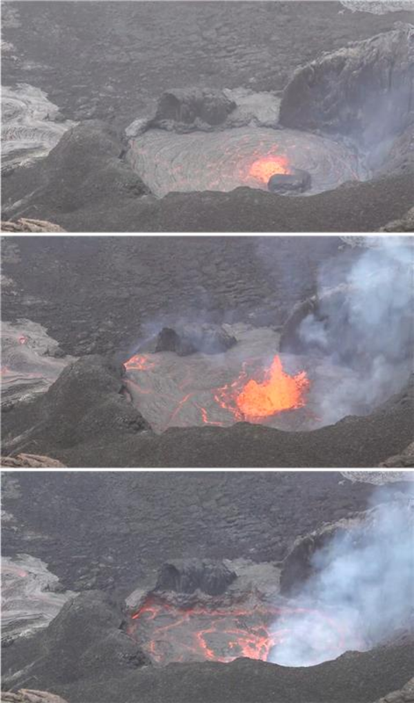
March 19, 2025 — Gas-piston cycle at Kīlauea summit
March 19, 2025 — Gas-piston cycle at Kīlauea summitIn the top panel, lava rises in the north vent in Halemaʻumaʻu prior to Episode 14 on March 19, 2025. Note that only a faint, hazy gas plume is visible near the right edge of the lava surface.
March 19, 2025 — Gas-piston cycle at Kīlauea summit
March 19, 2025 — Gas-piston cycle at Kīlauea summitIn the top panel, lava rises in the north vent in Halemaʻumaʻu prior to Episode 14 on March 19, 2025. Note that only a faint, hazy gas plume is visible near the right edge of the lava surface.
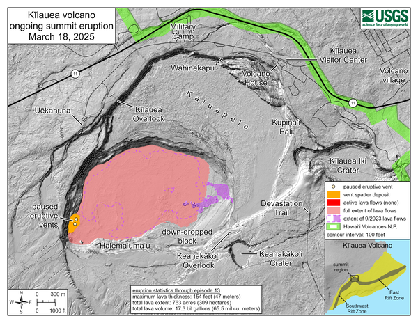
March 18, 2025—Kīlauea summit eruption reference map
March 18, 2025—Kīlauea summit eruption reference mapThis reference map depicts the Kīlauea summit eruption within Halema‘uma‘u crater that began on December 23, 2024. As of this posting on March 18, the eruption has had thirteen episodes, with the most recent occurring on March 11.

Aerial overview of Kīlauea summit tephra deposit
On Friday, March 14, Hawaiian Volcano Observatory geologists on a morning helicopter overflight captured aerial photography to map tephra deposits downwind (southwest) of vents from the Kīlauea summit eruption that began December 23, 2024.
On Friday, March 14, Hawaiian Volcano Observatory geologists on a morning helicopter overflight captured aerial photography to map tephra deposits downwind (southwest) of vents from the Kīlauea summit eruption that began December 23, 2024.

March 14, 2025 —Aerial view of Halema‘uma‘u crater
March 14, 2025 —Aerial view of Halema‘uma‘u craterA closer view of Halema‘uma‘u and the downdropped block, within the deepest portion of Kīlauea's summit caldera. Lava flows have crept eastward (towards bottom left in photo) as the crater floor rises with recent infilling. USGS photo taken on March 14, 2025, by M. Patrick.

March 14, 2025 — Kīlauea summit eruption overflight with Mauna Loa in the background
March 14, 2025 — Kīlauea summit eruption overflight with Mauna Loa in the backgroundA low-angle aerial view of the vents where episodic fountaining has been occurring since the start of the ongoing Kīlauea summit eruption on December 23, 2024. A white plume of volcanic gas rises from the north vent (center right) and south vent (center left) cones in the southwest corner of Halema‘uma‘u crater, as viewed during a monitoring overflight.

Low-level aerial view of Kīlauea summit tephra deposit
Low-level aerial view of Kīlauea summit tephra depositThis low-level aerial view of the tephra deposit from Kīlauea's ongoing summit eruption was captured during a Hawaiian Volcano Observatory helicopter overflight on Friday, March 14.
Low-level aerial view of Kīlauea summit tephra deposit
Low-level aerial view of Kīlauea summit tephra depositThis low-level aerial view of the tephra deposit from Kīlauea's ongoing summit eruption was captured during a Hawaiian Volcano Observatory helicopter overflight on Friday, March 14.

March 14, 2025—View of Kīlauea December 1974 fissures and lava flows
March 14, 2025—View of Kīlauea December 1974 fissures and lava flowsAn aerial view of the December 31, 1974 fissures and lava flows taken during an overflight of Kīlauea summit and upper Southwest Rift Zone on March 14, 2025. The 1974 eruption lasted 6 hours and occurred in Kīlauea's upper Southwest Rift Zone.

March 14, 2025 —Aerial view of September 2023 Kīlauea cones
March 14, 2025 —Aerial view of September 2023 Kīlauea conesOn the morning of March 14, USGS Hawaiian Volcano Observatory scientists conducted a monitoring overflight of Kīlauea. This aerial view shows cones formed during the September 2023 eruption, surrounded and partially buried by lava erupted within the past few weeks during the ongoing (and currently paused) eruption within Halema‘uma‘u. USGS photo by N. Deligne.

March 14, 2025—Kīlauea summit eruption overflight
Hawaiian Volcano Observatory geologists captured this aerial view of Kīlauea summit on March 14, 2025, during a helicopter overflight. Three days after the end of episode 13 of the ongoing eruption, the north and south cones are degassing in the southwest corner of Halema‘uma‘u.
Hawaiian Volcano Observatory geologists captured this aerial view of Kīlauea summit on March 14, 2025, during a helicopter overflight. Three days after the end of episode 13 of the ongoing eruption, the north and south cones are degassing in the southwest corner of Halema‘uma‘u.

March 14, 2025 — Kīlauea eruption remains on pause during summit overflight
March 14, 2025 — Kīlauea eruption remains on pause during summit overflightOn the morning of March 14, USGS Hawaiian Volcano Observatory scientists conducted an overflight of Kīlauea summit to capture thermal and surficial imagery of the ongoing (paused) eruption. Three days after the end of episode 13, this telephoto aerial view shows the north cone degassing in the southwest corner of Halema‘uma‘u.

Crater Rim Drive tephra blanket
The section of Crater Rim Drive downwind of the recent fountaining, and in an area closed to the public due to volcanic hazards, has been covered by numerous layers of tephra in the past several months. The tire tracks are centered over the Crater Rim Drive roadway, where USGS scientists access critical volcano monitoring sites.
The section of Crater Rim Drive downwind of the recent fountaining, and in an area closed to the public due to volcanic hazards, has been covered by numerous layers of tephra in the past several months. The tire tracks are centered over the Crater Rim Drive roadway, where USGS scientists access critical volcano monitoring sites.

HVO geologist services webcam day after episode 13 at Kīlauea
HVO geologist services webcam day after episode 13 at KīlaueaOn March 12, a USGS Hawaiian Volcano Observatory geologist on the southwest rim of Kaluapele (Kīlauea summit caldera) serviced the S2cam webcam. A plume of water vapor and volcanic gas rises from the two vents of the ongoing eruption within Halema‘uma‘u crater, one day after the 13th episode of the eruption. USGS photo by N. Deligne.