U.S. flag

An official website of the United States government

Images

Kīlauea images of eruptive activity, field work, and more.

Filter Total Items: 3024
Color photograph showing volcanic gas wafting over a tephra-blanketed crater rim
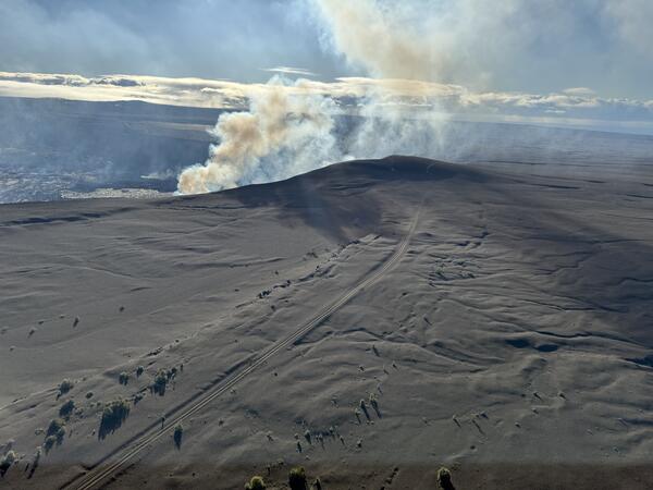
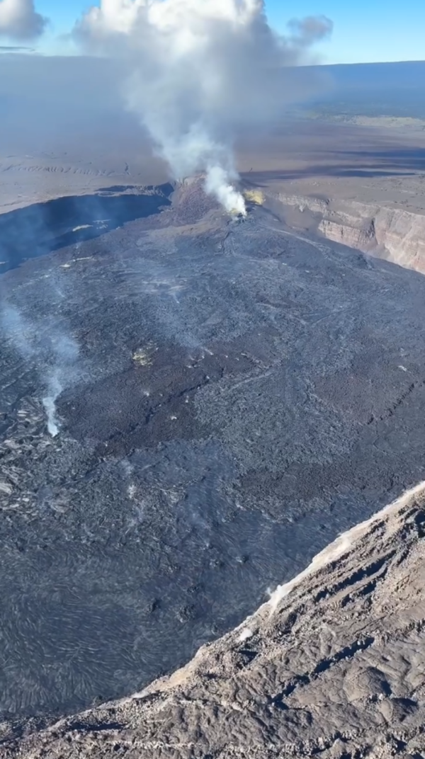
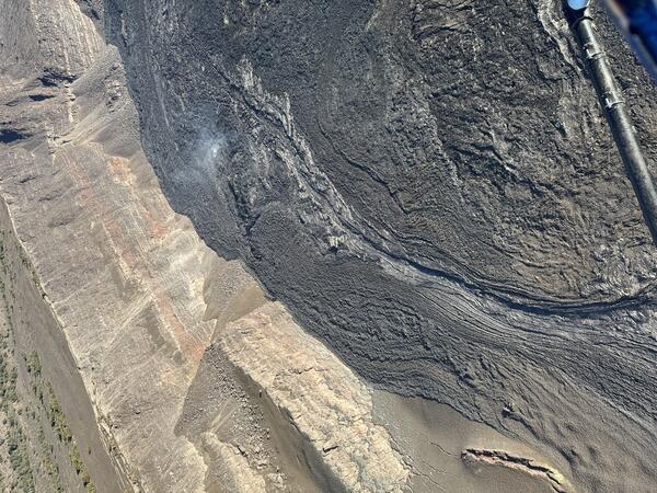
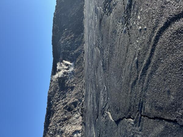
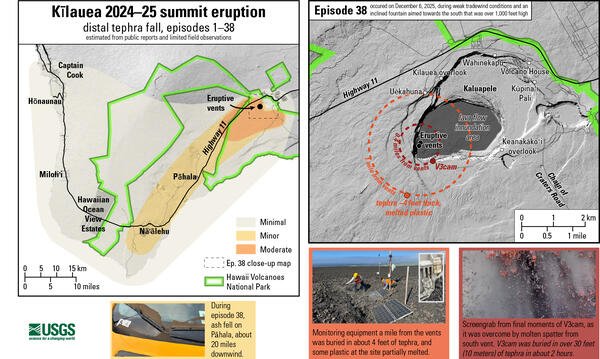
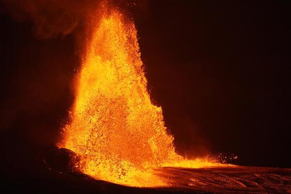
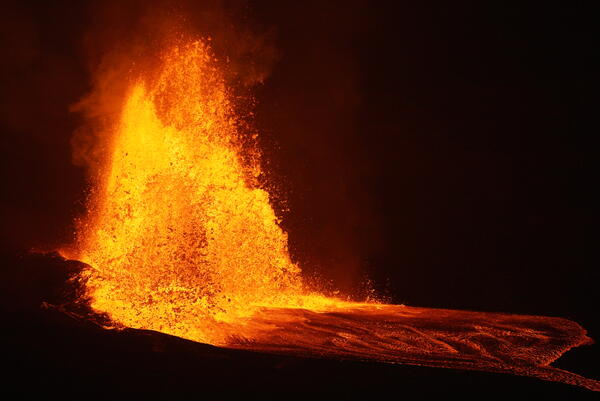
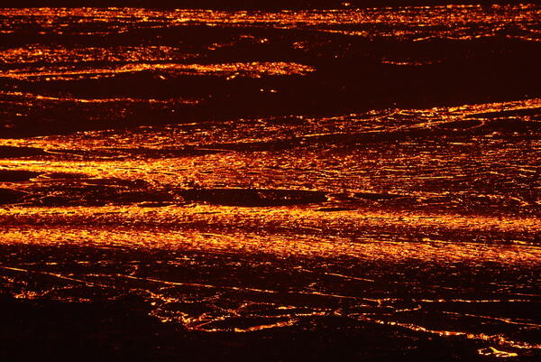
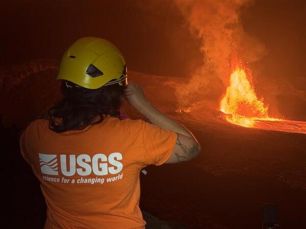
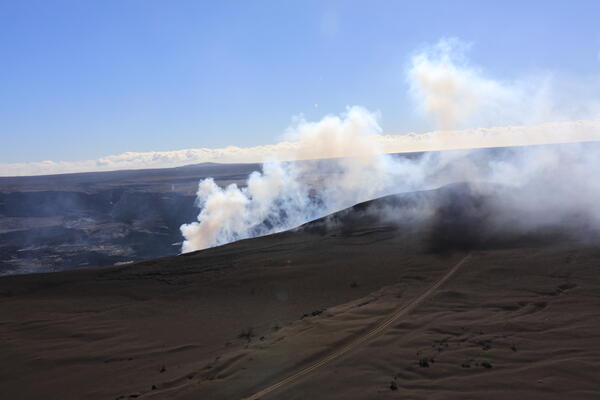
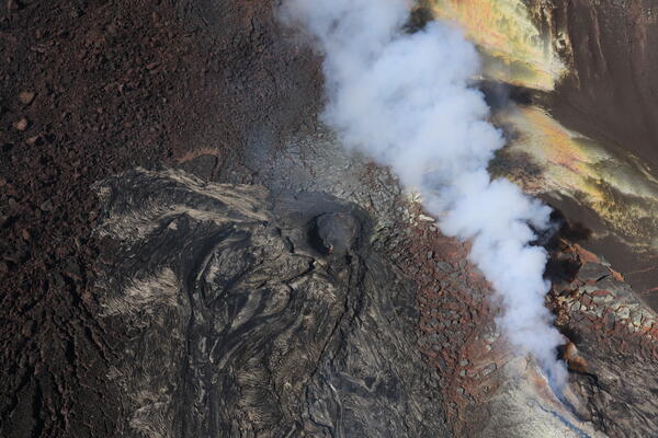
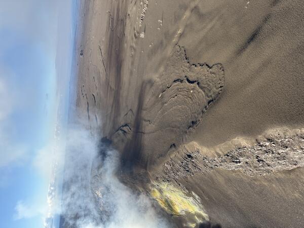
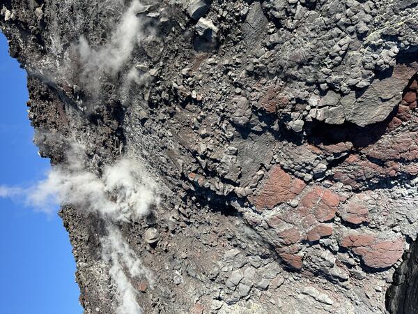
December 2, 2025—View of spatter-fed flow on crater rim, Kīlauea summit

This aerial photograph, taken during a USGS Hawaiian Volcano Observatory monitoring overflight the morning of December 2, 2025, shows volcanic gas wafting over the tephra-blanketed rim of Halemaʻumaʻu crater. The ripple-like deposits on the right side of the image, on the crater rim, are spatter-fed lava flows that formed during episode 34 on October 1.

This aerial photograph, taken during a USGS Hawaiian Volcano Observatory monitoring overflight the morning of December 2, 2025, shows volcanic gas wafting over the tephra-blanketed rim of Halemaʻumaʻu crater. The ripple-like deposits on the right side of the image, on the crater rim, are spatter-fed lava flows that formed during episode 34 on October 1.

Color photograph of degassing volcanic vent
December 2, 2025—View of degassing vents and tephra hill, Kīlauea summit

The north and south vents were degassing during a USGS Hawaiian Volcano Observatory monitoring overflight of Kīlauea summit on December 2, 2025. Eruptive activity at these vents was paused on December 2, following 9 hours of lava fountaining during episode 37 on November 25, but a spattering lava surface was visible deep within both vents. USGS photo by K.

The north and south vents were degassing during a USGS Hawaiian Volcano Observatory monitoring overflight of Kīlauea summit on December 2, 2025. Eruptive activity at these vents was paused on December 2, following 9 hours of lava fountaining during episode 37 on November 25, but a spattering lava surface was visible deep within both vents. USGS photo by K.

Color photograph of volcanic crater with vents and lava flows
December 2, 2025—Halemaʻumaʻu crater aerial overview

An aerial image of Halemaʻumaʻu crater, showing the degassing eruptive vents in the southwest part of the crater (background) and lava flows erupted during episode 37 on November 25 (foreground. This image was taken during a USGS Hawaiian Volcano Observatory monitoring overflight of Halema‘uma‘u crater on December 2, 2025. USGS photo by K. Mulliken. 

An aerial image of Halemaʻumaʻu crater, showing the degassing eruptive vents in the southwest part of the crater (background) and lava flows erupted during episode 37 on November 25 (foreground. This image was taken during a USGS Hawaiian Volcano Observatory monitoring overflight of Halema‘uma‘u crater on December 2, 2025. USGS photo by K. Mulliken. 

Color photograph of solidified lava channel next to crater wall
December 2, 2025—Solidified lava channel from the north vent in Halemaʻumaʻu, Kīlauea summit

This black solidified lava channel is a stark contrast to the weathered brown walls of Halemaʻumaʻu crater nearby. The lava channel transported lava from the north vent, along the north rim of the crater, allowing lava flows to reach the farthest regions of the crater to the east during the 9 hours of lava fountaining of episode 37 on November 25, 2025.

This black solidified lava channel is a stark contrast to the weathered brown walls of Halemaʻumaʻu crater nearby. The lava channel transported lava from the north vent, along the north rim of the crater, allowing lava flows to reach the farthest regions of the crater to the east during the 9 hours of lava fountaining of episode 37 on November 25, 2025.

Color photograph of volcanic vents degassing
December 2, 2025—Halemaʻumaʻu vents and puʻu

An aerial view of the volcanic vents in the southwest part of Halemaʻumaʻu crater, at the summit of Kīlaeua volcano. USGS photo by H. Winslow on December 2, 2025.  

An aerial view of the volcanic vents in the southwest part of Halemaʻumaʻu crater, at the summit of Kīlaeua volcano. USGS photo by H. Winslow on December 2, 2025.  

Color photograph of crater floor and steaming crater wall
December 2, 2025—Halemaʻumaʻu crater wall and new lava flows on floor

The USGS Hawaiian Volcano Observatory often gets asked how long it will take the lava flows to fill in Halemaʻumaʻu crater and spill onto the upper caldera floor of Kīlauea. This photo, taken from the floor of the crater, shows the lava flows from episode 37 (November 25) where they contact the north wall of the crater, which rises several hundred feet above.

The USGS Hawaiian Volcano Observatory often gets asked how long it will take the lava flows to fill in Halemaʻumaʻu crater and spill onto the upper caldera floor of Kīlauea. This photo, taken from the floor of the crater, shows the lava flows from episode 37 (November 25) where they contact the north wall of the crater, which rises several hundred feet above.

Color photograph of volcanic vents degassing
December 2, 2025—Halemaʻumaʻu vents degassing

An aerial view of the north (right) and south (left) vents in Halema'uma'u, taken during a USGS Hawaiian Volcano Observatory monitoring overflight the morning of December 2, 2025. Both vents were actively degassing, and a spattering lava surface was visible deep within their conduits.  USGS photo by D. Downs

An aerial view of the north (right) and south (left) vents in Halema'uma'u, taken during a USGS Hawaiian Volcano Observatory monitoring overflight the morning of December 2, 2025. Both vents were actively degassing, and a spattering lava surface was visible deep within their conduits.  USGS photo by D. Downs

Color photograph of a wall of rock
December 2, 2025—Halemaʻumaʻu crater wall

The steaming north wall of Halemaʻumaʻu crater wall rises several hundred feet above the lava flows that cover the floor of the crater.

The steaming north wall of Halemaʻumaʻu crater wall rises several hundred feet above the lava flows that cover the floor of the crater.

Color photograph of volcanic landscape
December 2, 2025—Kīlauea, Mauna Loa, and Mauna Kea

This aerial photograph shows Kīlauea, Mauna Loa and Mauna Kea. In the foreground is the forested area just north of Kīlauea caldera; the slope of Mauna Loa's Northeast Rift Zone rises to the left side of the image, while Mauna Kea is visible in the background. USGS photo by K. Mulliken. 

This aerial photograph shows Kīlauea, Mauna Loa and Mauna Kea. In the foreground is the forested area just north of Kīlauea caldera; the slope of Mauna Loa's Northeast Rift Zone rises to the left side of the image, while Mauna Kea is visible in the background. USGS photo by K. Mulliken. 

View of volcanic vent that is degassing
December 2, 2025—Aerial view into Halemaʻumaʻu north vent

During a USGS Hawaiian Volcano Observatory monitoring overflight the morning of December 2, 2025, geologists were able to see a spattering lava surface deep within the north vent. The yellow material around the vents is native sulfur.

During a USGS Hawaiian Volcano Observatory monitoring overflight the morning of December 2, 2025, geologists were able to see a spattering lava surface deep within the north vent. The yellow material around the vents is native sulfur.

Panel showing four color photographs of dust devils in volcanic eruption settings
Puahiohio (dust devils) at Kīlauea and Mauna Loa

Upper left: a dusty lava puahiohio (at right in frame) above the main 2022 Mauna Loa lava flow on 2 December 2022, with the eruptive plume further in the background (at left in frame). Upper right: a lava puahiohio rips up the crust of the Kīlauea summit lava lake on 7 June 2023.

Upper left: a dusty lava puahiohio (at right in frame) above the main 2022 Mauna Loa lava flow on 2 December 2022, with the eruptive plume further in the background (at left in frame). Upper right: a lava puahiohio rips up the crust of the Kīlauea summit lava lake on 7 June 2023.

Color maps showing distribution of lava fallout material during eruption conditions
Kīlauea 2024-25 summit eruption tephrafall

The left map shows the tephra fall associated with Kīlauea's episodic summit eruption, from December 2024-December 2025. Tephra is a generic word for any material erupted by a volcano that travels through the air before landing on the ground.

The left map shows the tephra fall associated with Kīlauea's episodic summit eruption, from December 2024-December 2025. Tephra is a generic word for any material erupted by a volcano that travels through the air before landing on the ground.

Color photograph of lava fountain
November 25, 2025—Kīlauea summit eruption episode 37

Episode 37 lava fountaining occurred On November 25, from 2:30 p.m. to 11:39 p.m., totaling just over 9 hours. Fountains were limited to the north vent, which sent lava flows over a large portion of the crater floor. Fountain heights reached 500-600 ft (150-180 meters). The south vent showed only weak spattering and flaming. USGS photo by M. Patrick. 

Episode 37 lava fountaining occurred On November 25, from 2:30 p.m. to 11:39 p.m., totaling just over 9 hours. Fountains were limited to the north vent, which sent lava flows over a large portion of the crater floor. Fountain heights reached 500-600 ft (150-180 meters). The south vent showed only weak spattering and flaming. USGS photo by M. Patrick. 

Color photograph of lava fountains
November 25, 2025—Kīlauea summit eruption episode 37 lava fountains

Following several days of precursory overflows and low dome fountaining, episode 37 of the Kīlauea summit eruption began yesterday at 2:30 p.m. with lava fountaining from the north vent.  A wide fountain developed, eventually reaching heights of 500-600 ft (150-180 meters), sending flows across a broad portion of the crater floor.

Following several days of precursory overflows and low dome fountaining, episode 37 of the Kīlauea summit eruption began yesterday at 2:30 p.m. with lava fountaining from the north vent.  A wide fountain developed, eventually reaching heights of 500-600 ft (150-180 meters), sending flows across a broad portion of the crater floor.

Telephoto of lava flow
November 25, 2025—Kīlauea summit eruption episode 37 lava flow

The telephoto shows lava flowing east across the floor of Halemaʻumaʻu crater, fed by the lava fountains in the west part of the crater.  Preliminary estimates suggest that approximately 6 million cubic meters (7.8 million cubic yards) of lava were erupted during episode 37, based on ground deformation data. USGS photo by M. Patrick. 

The telephoto shows lava flowing east across the floor of Halemaʻumaʻu crater, fed by the lava fountains in the west part of the crater.  Preliminary estimates suggest that approximately 6 million cubic meters (7.8 million cubic yards) of lava were erupted during episode 37, based on ground deformation data. USGS photo by M. Patrick. 

Color map showing area covered by lava flows in recent volcanic eruption
November 25, 2025—Kīlauea summit eruption reference map

This reference map depicts the Kīlauea summit eruption within Halema‘uma‘u crater that began on December 23, 2024. The data for this map were collected during a Hawaiian Volcano Observatory helicopter overflight on November 24, 2025; as such, the provided statistics are reflective of the first thirty-six episodes of the eruption through November 9.

This reference map depicts the Kīlauea summit eruption within Halema‘uma‘u crater that began on December 23, 2024. The data for this map were collected during a Hawaiian Volcano Observatory helicopter overflight on November 24, 2025; as such, the provided statistics are reflective of the first thirty-six episodes of the eruption through November 9.

Color photograph of scientist monitoring a volcanic eruption
November 25, 2025—Monitoring Kīlauea summit eruption episode 37

USGS Hawaiian Volcano Observatory scientists document lava fountains and lava flows during episode 37 of the ongoing Kīlauea summit eruption in Halemaʻumaʻu crater. From the rim of the crater, scientists can use a laser rangefinding device to approximately measure the lava fountain heights, and distance the lava flows have travelled. USGS photo by M.

USGS Hawaiian Volcano Observatory scientists document lava fountains and lava flows during episode 37 of the ongoing Kīlauea summit eruption in Halemaʻumaʻu crater. From the rim of the crater, scientists can use a laser rangefinding device to approximately measure the lava fountain heights, and distance the lava flows have travelled. USGS photo by M.

Color telephotograph of lava streams at night
November 25, 2025—Kīlauea summit eruption episode 37 lava flows

Telephoto view of lava flows on the floor of Halemaʻumaʻu crater. These lava flows were erupted during episode 37 of lava fountaining at the summit of Kīlauea, which was active for about 9 hours on November 25. USGS photo by M. Patrick. 

Telephoto view of lava flows on the floor of Halemaʻumaʻu crater. These lava flows were erupted during episode 37 of lava fountaining at the summit of Kīlauea, which was active for about 9 hours on November 25. USGS photo by M. Patrick. 

Color photograph of scientists in orange flight suits on a volcanic landscape
November 24, 2025 — Geologists visit Halema‘uma‘u

USGS Hawaiian Volcano Observatory scientists landed briefly on Halema‘uma‘u crater floor on November 24, 2025, during a Kīlauea summit monitoring overflight.

USGS Hawaiian Volcano Observatory scientists landed briefly on Halema‘uma‘u crater floor on November 24, 2025, during a Kīlauea summit monitoring overflight.

Color photograph of volcanic hill that is degassing
November 24, 2025 — The growing puʻu on the rim of Halema‘uma‘u

This aerial view looking to the southeast shows the volcanic gas plume being emitted from the vents of the ongoing Halema‘uma‘u eruption at Kīlauea summit.

Color photograph of volcanic vent that is degassing
November 24, 2025 — View into the Halema‘uma‘u vents

An aerial view looking down into the south vent (center) of the ongoing Kīlauea summit eruption within Halema‘uma‘u crater. A tiny spot of orange incandescent lava was visible deep in the south vent on the morning of November 24 during a USGS Hawaiian Volcano Observatory monitoring helicopter overflight.

An aerial view looking down into the south vent (center) of the ongoing Kīlauea summit eruption within Halema‘uma‘u crater. A tiny spot of orange incandescent lava was visible deep in the south vent on the morning of November 24 during a USGS Hawaiian Volcano Observatory monitoring helicopter overflight.

Was this page helpful?