An official website of the United States government
Here's how you know
Official websites use .gov
A .gov website belongs to an official government organization in the United States.
Secure .gov websites use HTTPS
A lock () or https:// means you’ve safely connected to the .gov website. Share sensitive information only on official, secure websites.
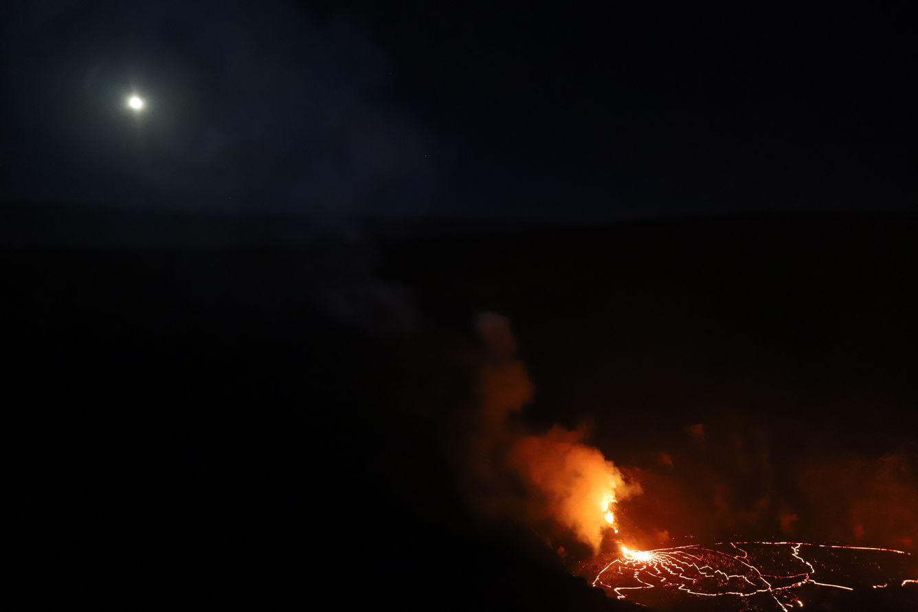
The eruption at Kīlauea's summit continues (Island of Hawai‘i). Halema‘uma‘u west vent remains active; the lava lake level has not changed significantly. Summit gas emissions and seismic activity remain elevated. With NPS permission, HVO field crews—equipped with specialized safety gear and PPE—monitor the current eruption from the closed
29 December 2020 - Kīlauea Volcano - US Geological Survey Hawaiian Volcano Observatory. This video, taken early morning on December 29, 2020, shows lava erupting from the west fissure in Halema‘uma‘u and pouring into the lava lake. Laser rangefinder measurements indicate that the opening lava pours from is 4-6 m (13-20 ft) wide. USGS video Hannah Dietterich (Public domain.)
This photo, taken at approximately 5:30 a.m. December 29, 2020, shows Kīlauea's ongoing summit eruption. The western vent in the wall of Halema‘uma‘u continued to erupt overnight, and the northern/eastern vent remained inactive. At approximately 3:45 a.m. HST today (Dec. 29), HVO field crews measured the lava lake as 179 m (587 ft) deep. USGS photo by H. Dietterich. (Public domain.)
HVO scientists monitor the ongoing Kīlauea summit eruption from within an area of Hawai‘i Volcanoes National Park that remains closed to the public for safety reasons. They are equipped with a range of specialized safety gear and personal protective equipment such as gas masks, helmets, gloves, and eye protection. No major changes were observed at the eruption site overnight and this morning: the west vent remains active and continues to feed the lava lake. USGS photo by L. DeSmither. (Public domain.)
The current eruption is confined to Halemaʻumaʻu crater within Hawai'i Volcanoes National Park but data from tiltmeters and Global Positioning System (GPS) stations show contraction in the upper portion of the East Rift Zone (an area between Kīlauea’s summit and Pu‘u ‘Ō‘ō). Similar instruments in down-rift areas, including the site of the 2018 eruption, are stable and do not show motion associated with either inflation or contraction. Recently, instruments at the summit have shown motions consistent with slight inflation. HVO interprets this as indicating that magma from the contracting portion of the East Rift Zone is flowing back to the summit reservoirs, where the eruption is occurring. The patterns of deformation could also be influenced by the decrease in the amount of lava erupted from the western fissure, and the draining of lava into the now submerged northern fissure vent. The signal is small and preliminary modeling shows it to be a small amount of magma returning to the summit. While magma from the summit reservoirs drained into the East Rift Zone to feed fissure eruptions in the lower East Rift Zone in 2018, there is no seismic or deformation data to indicate any changes have occurred in Kīlauea volcano’s lower East Rift Zone. No new hazards are expected as a result of this activity. This photo, taken on December 22, 2020, shows an HVO geophysicist installing a new Global Positioning System (GPS) station on the portion of Kīlauea's caldera that down-dropped during the 2018 summit collapse. The summit eruption plume is visible in the background. USGS photo by K. Kamibayashi. (Public domain.)
HVO field crews observing Kīlauea's summit lava lake this morning noted intermittent spattering from the west vents in Halema‘uma‘u. This photo, taken at approximately 11 a.m. HST on December 29, 2020, shows lava flowing from the west vent area into the lava lake (left side of photo). Over the past day, the main island of cooler, solidified lava floating in the lava lake (photo center) drifted slowly westward in the lake until about 10 p.m. HST last night (Dec. 28) when it stalled along with 10 or so much smaller islands to the east. The main island measured about 250 m (820 ft) in length, 135 m (440 ft) in width, and about 3 ha (7 acres) in area based on the Dec. 28 thermal map. This morning, the main island was still stalled but rotating slowly. Measurements on Dec. 27 show that the island surface was about 6 m (20 ft) above the lake surface. The inactive north vent is visible in the center of Halema‘uma‘u wall. USGS photo by L. DeSmither. (Public domain.)
Kīlauea Volcano's summit is dynamic and has experienced many changes over the past several years. Most recently, the deepest part of the summit that collapsed in 2018, Halema‘uma‘u, has been filled with a new lava lake, which is visible beyond the collapsed edge of Crater Rim Drive in this photograph. This photo was taken in an area of Hawai‘i Volcanoes National Park that remains closed to the public for safety reasons. USGS photo by C. Parcheta at about 4 p.m. on December 29, 2020.