An official website of the United States government
Here's how you know
Official websites use .gov
A .gov website belongs to an official government organization in the United States.
Secure .gov websites use HTTPS
A lock () or https:// means you’ve safely connected to the .gov website. Share sensitive information only on official, secure websites.
Kīlauea's summit is no longer erupting; lava supply to the Halemaʻumaʻu lava lake has ceased and sulfur dioxide emissions have decreased to near pre-eruption background levels. HVO field crews—equipped with specialized safety gear—monitor for new changes from within the closed area of Hawai‘i Volcanoes National Park with NPS permission.
HVO scientists collect detailed data to assess hazards and understand evolving processes at Kīlauea's summit, all of which are shared with the National Park Service and emergency managers. Access to this hazardous area is by permission from, and in coordination with, Hawai‘i Volcanoes National Park.
July 22, 2021 — Kīlauea
Kīlauea summit overflight and field work, July 22, 2021
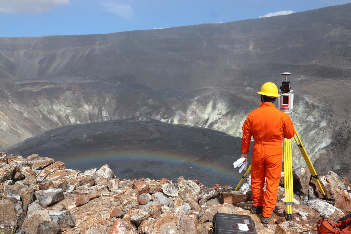
An HVO geologist conducts a routine high-precision survey of the inactive lava lake in Halema‘uma‘u, at the summit of Kīlauea volcano. Mist moving across the caldera on the morning of July 22 produced a rainbow over the lake. No significant changes have occurred in Halema‘uma‘u in recent weeks. USGS photo by M. Patrick.
HVO geologists conducted a gas mapping mission on the down-dropped block that subsided during the 2018 collapses at Kīlauea summit. The cliff face that covers much of the image formed during successive collapse events in 2018 as the foreground subsided. The 2018 cliff in this area is about 100 meters (330 feet) high. The two HVO geologists can be seen as tiny spots in the lower left portion of the photo, in the steaming area, giving a sense of the scale of the cliff. USGS photo by M. Patrick, taken on July 22, 2021.
This aerial photo of the inactive lava lake within Halema‘uma‘u at the summit of Kīlauea was captured during a routine helicopter overflight by HVO geologists on Thursday, July 22, 2021. Here, the lava lake is viewed from the northeast, with the oldest parts of the lake surface—the first to crust over—visible on the near side, and the most recently active areas in the far end. Also visible are the high crater walls that tower over the south side of the lake (upper-left). For scale, the very top of this cliff is standing approximately 355 m (1165 ft) above the surface of the lava lake. USGS photo taken by M. Zoeller.
This wide-angle aerial view looks southeast over Kīlauea's summit caldera, with the recently active lava lake in Halema‘uma‘u visible in the lower right. On the left side of the photo, the large cliffs formed during the 2018 collapses are visible. Kīlauea Iki can be seen in the upper left. USGS photo by M. Patrick, taken on July 22, 2021.
On July 22, HVO scientists surveyed the floor of the down-dropped block within Kīlauea caldera for diffuse volcanic gas emissions. This particular part of the caldera floor subsided during Kīlauea's collapse events in 2018. The caldera-wide ongoing gas survey will be compared to gas surveys done in the area prior to the 2018 collapse events and will reveal any changes in Kīlauea summit gas pathways and emissions. This photo shows two scientists surveying a portion of the caldera floor near the south sulfur bank, which was exposed in 2018 and is visible as the white-colored walls in the background of the photo. USGS image by K. Mulliken.
HVO scientists walk transects along the down-dropped portion of Kīlauea caldera floor as part of a gas survey conducted on July 22. The multigas instruments carried on the scientists' backs measure the amount of carbon dioxide (CO2), sulfur dioxide (SO2), water vapor (H2O), and hydrogen sulfide (H2S) via an inlet hose oriented toward the ground surface. These measurements will provide a map showing areas of the caldera floor where specific volcanic gases are being emitted and their concentrations. The light-colored ground the scientists are walking on is evidence of such gases interacting with, and altering, the darker volcanic rocks in the area. USGS image by K. Mulliken.
An HVO scientist samples the gas around a crack identified as emitting elevated levels of carbon dioxide (a volcanic gas) on the down-dropped block within Kīlauea caldera. The sample will later be analyzed to determine its complete chemical composition. This work was conducted within a closed area of Hawai‘i Volcanoes National Park, with park permission. Scientists wore hard hats as they worked in the vicinity of steep caldera walls, and they carried other safety gear such as gas masks and satellite communication devices. USGS image by K. Mulliken, taken on July 22, 2021.