An official website of the United States government
Here's how you know
Official websites use .gov
A .gov website belongs to an official government organization in the United States.
Secure .gov websites use HTTPS
A lock () or https:// means you’ve safely connected to the .gov website. Share sensitive information only on official, secure websites.
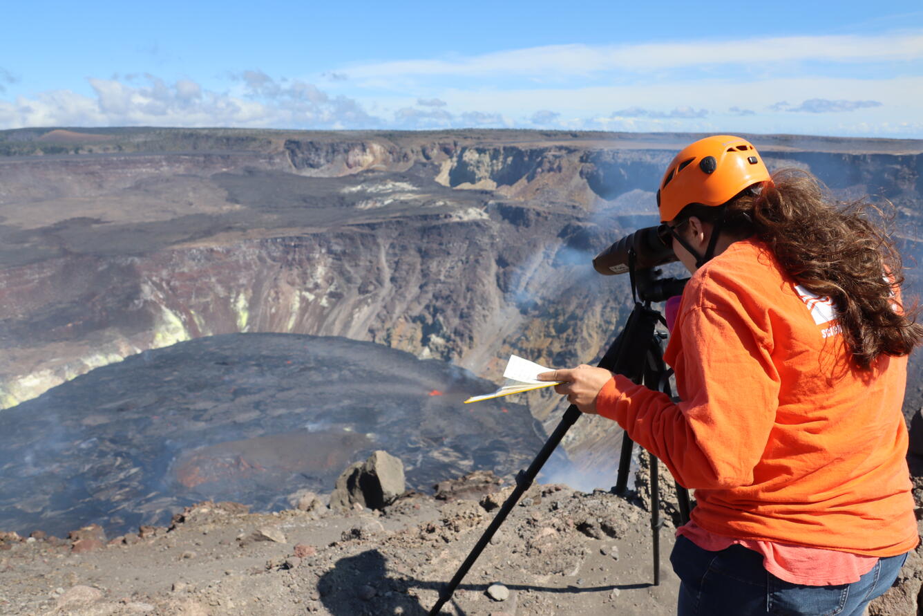
A new eruption at Kīlauea's summit began at approximately 3:20 p.m. HST on September 29, 2021. Lava activity is currently confined within Halema'uma'u crater. Gas emissions and seismic activity at the summit remain elevated. HVO field crews—equipped with specialized safety gear—monitor the eruption from within the closed area of Hawai‘i V
HVO scientists collect detailed data to assess hazards and understand how the eruption is evolving at Kīlauea's summit, all of which are shared with the National Park Service and emergency managers. Access to this hazardous area is by permission from, and in coordination with, Hawai‘i Volcanoes National Park.
A wide view of the lava lake in Halema‘uma‘u crater, at the summit of Kīlauea, taken from the western crater rim. The western vent (lower right) remains the dominant source of fountaining, while low lava fountains are still emerging through the southern portion of the lava lake (center right). USGS photo by M. Patrick taken on October 4, 2021.
A telephoto image of fountaining from the western vent in Halema‘uma‘u crater, at the summit of Kīlauea. Spatter from the fountain continues to build up a cone around the vent, which is almost entirely out of view from this angle. This photo was taken from the western crater rim on October 4, 2021. USGS photo by M. Patrick.
A close-up view of the western fissure and lava lake in Halema‘uma‘u crater, at the summit of Kīlauea. The lava lake crust develops a complex pattern as it flows away from its source at the western vent (bottom right). USGS photo by M. Patrick taken on October 4, 2021.
A Hawaiian Volcano Observatory (HVO) geologist uses a laser rangefinder to measure the elevation of the active lava lake in Halema‘uma‘u crater, at the summit of Kīlauea. HVO scientists continue to monitor the ongoing eruption from an area within Hawai‘i Volcanoes National Park that remains closed to the public due to safety concerns. USGS photo taken by M. Patrick on October 4, 2021.
A telephoto view of fountaining at the western vent in Halema‘uma‘u crater, at the summit of Kīlauea. Spatter from the fountain has built a horseshoe-shaped cone around the vent in the western crater wall. Molten spatter accumulating on the cone forms a tiny stream of lava down the north side (bottom center). This photo was taken on October 4, 2021, from the northwest caldera rim. USGS photo by M. Patrick.
An overflow of lava from the active lake (left) poured onto and along the levee (right) on the eastern end of the lava lake in Halema‘uma‘u crater, at the summit of Kīlauea. USGS photo by M. Patrick taken on October 4, 2021.
A brief gap in the fume provides a clear view of the fountaining at the western vent in Halema‘uma‘u crater, at the summit of Kīlauea. Sulfur dioxide (SO2) emission rates remain elevated and were measured at approximately 7,000 tonnes per day on October 4. USGS photo taken by M. Patrick from the southern crater rim on October 4, 2021.
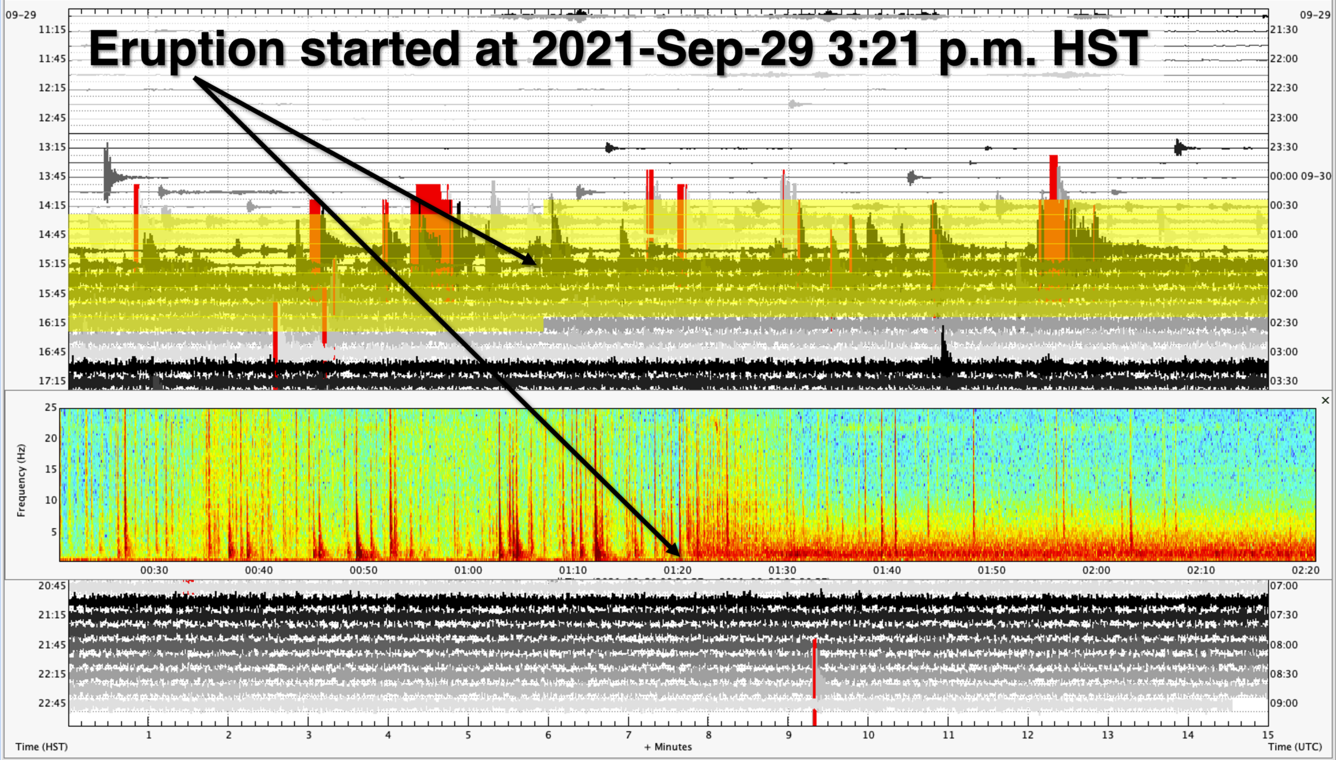
Seismic record from a Kīlauea summit seismic station showing the onset of the new eruption within Halema‘uma‘u. The background image is a webicorder of station RIMD, showing 12 hours of data. Each line shows 15 minutes of seismic data starting from the upper-left corner at 11:00 a.m. HST on September 29, 2021, and ending in the lower-right at 11:00 p.m. HST. The yellow area on this webicorder highlights the 2-hour time period shown in the spectrogram inset. In this inset, warmer colors represent higher energy signals, while the cooler colors show weaker signals. Prior to the start of the eruption, distinct earthquake signals (spikes of red) are visible in the record. Once the eruption began at approximately 3:21 p.m. HST on September 29, 2021, all but a few larger earthquakes have been “drowned-out” by the volcanic tremor (thick band of red at the bottom right-half of the inset) that started with the eruption. USGS figure by J. Chang.
Lava fountains through the southern part of the lava lake in Halema‘uma‘u, at Kīlauea's summit during the ongoing eruption. Sustained fountain heights from this fissure ranged from about 5–10 meters (16–33 ft) with occasional higher bursts of spatter. This video clip was recorded on October 2, 2021, from the southern crater rim. USGS video by L. DeSmither.
Lava fountains from the western fissure vent in the Halema‘uma‘u crater wall, at Kīlauea's summit during the ongoing eruption. Sustained fountain heights from this fissure ranged from about 10–15 meters (33–49 ft) with occasional higher bursts of spatter. This video clip was recorded on October 2, 2021, from the western crater rim. USGS video by L. DeSmither.
Low lava fountains near the southeast edge of the main island in the Halema‘uma‘u lava lake, during the ongoing Kīlauea summit eruption. One of the small (less than 5 meters or 16 feet) fountains has built a cone on the edge of the island. Occasional spatter is visibly ejected from the vent at the top of the cone while the main fountain is directed laterally onto the lava lake surface from within the grotto that it formed near the base of the island. This video clip was recorded on October 2, 2021, from the southern crater rim. USGS video by L. DeSmither.