
Three young (1350 CE) craters formed by phreatic, or steam-driven, eruptions.
Geologic Summary
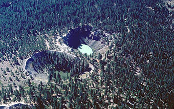
The Inyo Craters are three north-south-aligned phreatic (steam) explosion craters on the summit and south flank of Deer Mountain. Deer Mountain is an approximately 115,000-year-old rhyolite (high silica volcanic rock) dome in the west moat of the caldera that was erupted from the residual Long Valley Caldera magma. The two southernmost craters (informally designated as north crater and south crater) average about 200 m (660 ft) in diameter and are about 60 m (200 ft) deep. They both contain small lakes. The crater on the summit of Deer Mountain (informally referred to as summit crater) is smaller, irregular in outline, breached on its south side, and dry. The craters were formed in the mid-14th century shortly after the eruption of Deadman Creek, Obsidian, and Glass Creek domes in 1350 CE (Millar, et al., 2006). See the Obsidian Dome field guide page page for more information about the 1350 CE eruptions.
Despite apparent differences in shape and vegetation, all three craters formed at nearly the same time, probably within hours or days. They erupted in succession from north to south (summit crater was the first to erupt), as the light-colored deposits from summit crater underlie the darker ones of north crater, which in turn underlie the darkest ones of south crater—relations that are well exposed in the northeast wall of north crater and on the east flank of Deer Mountain (Mastin and Pollard, 1988).
The ground around the craters is broken by many north-trending faults and fissures that probably formed as a consequence of uplift and expansion above a dike (intruding magma) (Mastin and Pollard, 1988). The rising magma most likely encountered water causing explosive flashing of the water to steam. The steam formed a vent through the overlying andesitic rocks, producing the Inyo explosion craters and surrounding phreatic (steam) deposits. Surprisingly no juvenile (new) rhyolite magma reached the surface during the eruptions.
Many volcanic eruptions are preceded by phreatic explosions that create craters, and several such explosion craters exist in the Mammoth Lakes area. If magma had come to the surface, the craters would likely be covered by domes. See the Panum Crater stop for an explanation of a dome eruption cycle. See the Horseshoe Lake stop for more information about magmatic gases coming to the surface from magma that has stalled at depth and started to cool.
References
Mastin, Larry G. and Pollard, David D., 1988, Surface Deformation and Shallow Dike Intrusion Processes at Inyo Craters, Long Valley, California, Journal of Geophysical Research, Vol. 93, No B11, p. 13,221–13,235.C.I.
Millar, King, John C., Westfall, Robert D., Alden, Harry A., Delany, Diane L., 2006, Late Holocene forest dynamics, volcanism, and climate change at Whitewing Mountain and San Joaquin Ridge, Mono County, Sierra Nevada, CA, USA, Quaternary Research 66, 273–287.
Field Stop Location: Inyo Craters
Quadrangle: Old Mammoth and Mammoth Mountain, California 7.5 minute topographic quadrangle
Coordinates: 37° 41.278' N, 119° 00.347' W- parking
Approximate Elevation: 8,080 ft (2,463 m)-parking, 8,222 ft (2506 m)-southernmost crater
Directions to Inyo Craters:
Access to the Inyo Craters is via the Mammoth Scenic Loop (turnoff at, 37°42.555' N, 118°57.143 W).
| Directions from Mammoth Lakes exit U.S. 395 and CA-203 | Go this distance |
|---|---|
| 1. Zero your odometer at the intersection of Highway 395 and Highway 203. Head north on US-395 towards Lee Vining and Mono Lake. | Go 5.2 miles |
| 2. Turn left onto the Mammoth Scenic Loop Road (Dry Creek Road). Follow the paved Scenic Loop to the Inyo Craters sign. | Go 3.2 miles |
| 3. Turn right at (at coordinates 37°40.903' N 118°59.686' W) onto Inyo Craters Road (Dry Creek Road Spur). This winding unpaved road is not plowed in the winter. Continue following Inyo Craters signs to the visitors' parking area. | 1.3 miles |
| 4. Park and follow the well-worn foot path west 0.3 mi (500 m) to the craters. |

Long Valley Caldera Field Guide

Long Valley Caldera Field Guide - Glass Creek Flow

Long Valley Caldera Field Guide - Horseshoe Lake

Long Valley Caldera Field Guide - Hot Creek Geologic Site

Long Valley Caldera Field Guide - Inyo Craters
Long Valley Caldera Field Guide - Lookout Mountain

Long Valley Caldera Field Guide - Mammoth Mountain

Long Valley Caldera Field Guide - Mono Lake
Long Valley Caldera Field Guide - Obsidian Dome
Long Valley Caldera Field Guide - Panum Crater
Three young (1350 CE) craters formed by phreatic, or steam-driven, eruptions.
Geologic Summary
The Inyo Craters are three north-south-aligned phreatic (steam) explosion craters on the summit and south flank of Deer Mountain. Deer Mountain is an approximately 115,000-year-old rhyolite (high silica volcanic rock) dome in the west moat of the caldera that was erupted from the residual Long Valley Caldera magma. The two southernmost craters (informally designated as north crater and south crater) average about 200 m (660 ft) in diameter and are about 60 m (200 ft) deep. They both contain small lakes. The crater on the summit of Deer Mountain (informally referred to as summit crater) is smaller, irregular in outline, breached on its south side, and dry. The craters were formed in the mid-14th century shortly after the eruption of Deadman Creek, Obsidian, and Glass Creek domes in 1350 CE (Millar, et al., 2006). See the Obsidian Dome field guide page page for more information about the 1350 CE eruptions.
Despite apparent differences in shape and vegetation, all three craters formed at nearly the same time, probably within hours or days. They erupted in succession from north to south (summit crater was the first to erupt), as the light-colored deposits from summit crater underlie the darker ones of north crater, which in turn underlie the darkest ones of south crater—relations that are well exposed in the northeast wall of north crater and on the east flank of Deer Mountain (Mastin and Pollard, 1988).
The ground around the craters is broken by many north-trending faults and fissures that probably formed as a consequence of uplift and expansion above a dike (intruding magma) (Mastin and Pollard, 1988). The rising magma most likely encountered water causing explosive flashing of the water to steam. The steam formed a vent through the overlying andesitic rocks, producing the Inyo explosion craters and surrounding phreatic (steam) deposits. Surprisingly no juvenile (new) rhyolite magma reached the surface during the eruptions.
Many volcanic eruptions are preceded by phreatic explosions that create craters, and several such explosion craters exist in the Mammoth Lakes area. If magma had come to the surface, the craters would likely be covered by domes. See the Panum Crater stop for an explanation of a dome eruption cycle. See the Horseshoe Lake stop for more information about magmatic gases coming to the surface from magma that has stalled at depth and started to cool.
References
Mastin, Larry G. and Pollard, David D., 1988, Surface Deformation and Shallow Dike Intrusion Processes at Inyo Craters, Long Valley, California, Journal of Geophysical Research, Vol. 93, No B11, p. 13,221–13,235.C.I.
Millar, King, John C., Westfall, Robert D., Alden, Harry A., Delany, Diane L., 2006, Late Holocene forest dynamics, volcanism, and climate change at Whitewing Mountain and San Joaquin Ridge, Mono County, Sierra Nevada, CA, USA, Quaternary Research 66, 273–287.
Field Stop Location: Inyo Craters
Quadrangle: Old Mammoth and Mammoth Mountain, California 7.5 minute topographic quadrangle
Coordinates: 37° 41.278' N, 119° 00.347' W- parking
Approximate Elevation: 8,080 ft (2,463 m)-parking, 8,222 ft (2506 m)-southernmost crater
Directions to Inyo Craters:
Access to the Inyo Craters is via the Mammoth Scenic Loop (turnoff at, 37°42.555' N, 118°57.143 W).
| Directions from Mammoth Lakes exit U.S. 395 and CA-203 | Go this distance |
|---|---|
| 1. Zero your odometer at the intersection of Highway 395 and Highway 203. Head north on US-395 towards Lee Vining and Mono Lake. | Go 5.2 miles |
| 2. Turn left onto the Mammoth Scenic Loop Road (Dry Creek Road). Follow the paved Scenic Loop to the Inyo Craters sign. | Go 3.2 miles |
| 3. Turn right at (at coordinates 37°40.903' N 118°59.686' W) onto Inyo Craters Road (Dry Creek Road Spur). This winding unpaved road is not plowed in the winter. Continue following Inyo Craters signs to the visitors' parking area. | 1.3 miles |
| 4. Park and follow the well-worn foot path west 0.3 mi (500 m) to the craters. |
Long Valley Caldera Field Guide
Long Valley Caldera Field Guide - Glass Creek Flow
Long Valley Caldera Field Guide - Horseshoe Lake
Long Valley Caldera Field Guide - Hot Creek Geologic Site
Long Valley Caldera Field Guide - Inyo Craters
Long Valley Caldera Field Guide - Lookout Mountain
Long Valley Caldera Field Guide - Mammoth Mountain
Long Valley Caldera Field Guide - Mono Lake
Long Valley Caldera Field Guide - Obsidian Dome