Seismic station VALT in Mount St. Helens crater, view toward the south
Seismic station VALT in Mount St. Helens crater, view toward the southSeismic station VALT in Mount St. Helens crater, view toward the south.

Official websites use .gov
A .gov website belongs to an official government organization in the United States.
Secure .gov websites use HTTPS
A lock () or https:// means you’ve safely connected to the .gov website. Share sensitive information only on official, secure websites.
Images related to Mount St. Helens.

Seismic station VALT in Mount St. Helens crater, view toward the south.
Seismic station VALT in Mount St. Helens crater, view toward the south.

The USGS operates a real-time lake elevation monitoring gage on Spirit Lake to ensure water level does not exceed a safe limit. In 1985, the U.S.
The USGS operates a real-time lake elevation monitoring gage on Spirit Lake to ensure water level does not exceed a safe limit. In 1985, the U.S.

Helicopter dropping off monitoring equipment at Mount St. Helens, Washington.
Helicopter dropping off monitoring equipment at Mount St. Helens, Washington.

Eruptions in the Cascade Range during the past 4000 years. USGS GIP 64
Eruptions in the Cascade Range during the past 4000 years. USGS GIP 64

USGS scientist observing Mount St. Helens' crater and dome from the Brutus Camera station.
USGS scientist observing Mount St. Helens' crater and dome from the Brutus Camera station.

Mount Adams western profile as seen from Mount St. Helens.
Mount Adams western profile as seen from Mount St. Helens.

Monitoring station VALT was installed on the crater floor of Mount St. Helens in 2006. It was called VALT because a vault-like structure about the size of a large doghouse was built into the rocky deposits to protect the state-of-the-art (at that time) broadband seismometer from environmental variables such as temperature and humidity.
Monitoring station VALT was installed on the crater floor of Mount St. Helens in 2006. It was called VALT because a vault-like structure about the size of a large doghouse was built into the rocky deposits to protect the state-of-the-art (at that time) broadband seismometer from environmental variables such as temperature and humidity.

Seismic station at Yellow Rock (YEL) with the toe of the west arm of Crater Glacier in the background. This station site was eventually covered by the glacier.
Seismic station at Yellow Rock (YEL) with the toe of the west arm of Crater Glacier in the background. This station site was eventually covered by the glacier.

Panoramic photograph from the southern rim of Mount St. Helens' crater rim looking north with accompanying annotation.
Panoramic photograph from the southern rim of Mount St. Helens' crater rim looking north with accompanying annotation.

View the annotated version of this photograph.
View the annotated version of this photograph.

View northward from Mount St. Helens' crater rim, July 2006.
View northward from Mount St. Helens' crater rim, July 2006.

View the annotated image.

Helicopter flying toward lava spine at Mount St. Helens to collect rocks—note the "Jaws" collector hanging underneath. April 28, 2007
Helicopter flying toward lava spine at Mount St. Helens to collect rocks—note the "Jaws" collector hanging underneath. April 28, 2007

Due to the cataclysmic eruption of May 18, 1980, many of the locations annotated on this map are now either covered or no longer visible.
Due to the cataclysmic eruption of May 18, 1980, many of the locations annotated on this map are now either covered or no longer visible.
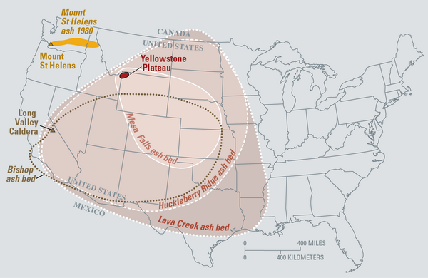
Eruptions of the Yellowstone volcanic system have included the two largest volcanic eruptions in North America in the past few million years; the third largest was at Long Valley in California and produced the Bishop ash bed. The biggest of the Yellowstone eruptions occurred 2.1 million years ago, depositing the Huckleberry Ridge ash bed.
Eruptions of the Yellowstone volcanic system have included the two largest volcanic eruptions in North America in the past few million years; the third largest was at Long Valley in California and produced the Bishop ash bed. The biggest of the Yellowstone eruptions occurred 2.1 million years ago, depositing the Huckleberry Ridge ash bed.

Mount Adams, Washington as seen from Mount St. Helens (west). Trees are covered in frost in the foreground.
Mount Adams, Washington as seen from Mount St. Helens (west). Trees are covered in frost in the foreground.

Loowit Falls flows north out of Mount St. Helens crater. White building in upper right corner is the Loowit gage house, which contains an Acoustic Flow Monitor.
Loowit Falls flows north out of Mount St. Helens crater. White building in upper right corner is the Loowit gage house, which contains an Acoustic Flow Monitor.

South-facing aerial view of Mount St. Helens with Mount Hood (left) and Mount Jefferson (right) on the horizon. June 8, 2005.
South-facing aerial view of Mount St. Helens with Mount Hood (left) and Mount Jefferson (right) on the horizon. June 8, 2005.

Ash collection from east Crater Glacier on Mount St. Helens with a dredge attached to a helicopter cable. Ash is analyzed to help scientists understand eruption characteristics.
Ash collection from east Crater Glacier on Mount St. Helens with a dredge attached to a helicopter cable. Ash is analyzed to help scientists understand eruption characteristics.

The May 18, 1980 eruption of Mount St. Helens began with an enormous landslide that slammed into Spirit Lake, blocking its natural outlet and raising the lake level by 197 feet.
The May 18, 1980 eruption of Mount St. Helens began with an enormous landslide that slammed into Spirit Lake, blocking its natural outlet and raising the lake level by 197 feet.

Aerial view, Mount St. Helens' crater and dome, as seen from the northeast. Note dusting of ash on Mount St. Helens' flank, left near rim.
Aerial view, Mount St. Helens' crater and dome, as seen from the northeast. Note dusting of ash on Mount St. Helens' flank, left near rim.