U.S. flag

An official website of the United States government

Dr. Nathan Miller, Research Geophysicist from the USGS Woods Hole Coastal and Marine Science Center,  led a study on new analysis of seismic data from the Middle America Trench suggesting that previous calculations have vastly overestimated the total amount of water transported to the mantle worldwide.

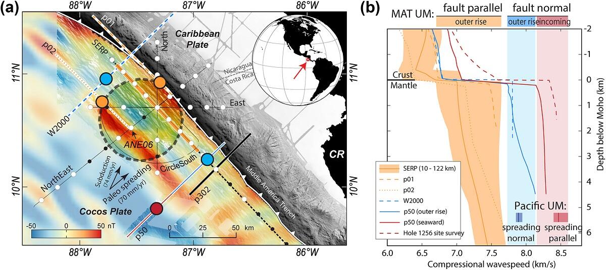
The research, published in Journal of Geophysical Research: Solid Earth, suggests water transport at the Middle America Trench subduction zone is less than previously estimated. Seismic anisotropy measurements show that upper mantle hydration at the Middle America Trench (MAT) is limited to serpentinization and/or water in fault zones, rather than distributed uniformly.   The researchers used data collected by seafloor seismometers to measure seismic anisotropy along the Middle America Trench near Nicaragua, which enabled a much more detailed picture of upper mantle hydration.

Middle America Trench offshore Nicaragua and Costa Rica
(a) Middle America Trench offshore Nicaragua and Costa Rica. Highlighted dashed circle is the bin used to select ray bottoming locations for the outer‐rise anisotropy solutions. Thick lines mark published 2D seismic tomograms. Colored large circles mark the location of the profiles in (b). Small white and black circles mark OBS locations. White circles are sites used in the anisotropy solutions.

Get Our News

These items are in the RSS feed format (Really Simple Syndication) based on categories such as topics, locations, and more. You can install and RSS reader browser extension, software, or use a third-party service to receive immediate news updates depending on the feed that you have added. If you click the feed links below, they may look strange because they are simply XML code. An RSS reader can easily read this code and push out a notification to you when something new is posted to our site.