
A magnitude 7.0 earthquake ruptured the Mendocino Transform Fault offshore Northern California on December 5, 2024. The USGS and colleagues from the Woods Hole Oceanographic Institution’s Ocean Bottom Seismic Instrument Center deployed our new fleet of rapid response ocean bottom seismographs just 11 days later—the fastest response in U.S. history.
Nathaniel C Miller, PhD
Research Geophysicist with the Woods Hole Coastal and Marine Science Center
Science and Products

Cascadia Subduction Zone Marine Geohazards
Societal Issue: Uncertainty related to rupture extent, slip distribution, and recurrence of past subduction megathrust earthquakes in the Pacific Northwest (northern CA, OR, WA, and southern BC) leads to ambiguity in earthquake and tsunami hazard assessments and hinders our ability to prepare for future events.
By
Natural Hazards Mission Area, Coastal and Marine Hazards and Resources Program, Pacific Coastal and Marine Science Center, Santa Cruz Core Scanning Laboratory, Santa Cruz Core Laboratories, Santa Cruz Core Splitting Laboratory, Deep Sea Exploration, Mapping and Characterization, Subduction Zone Science

The Mid-Atlantic Resource Imaging Experiment (MATRIX)
In late August 2018, scientists and technical staff from the USGS Coastal and Marine Hazards and Resources Program completed the acquisition of over 2000 km of multichannel seismic (MCS) data as part of the Mid-Atlantic Resource Imaging Experiment (MATRIX) conducted aboard the R/V Hugh R. Sharp. The seismic program was led by the USGS Gas Hydrates Project and was sponsored by the USGS, the U.S...
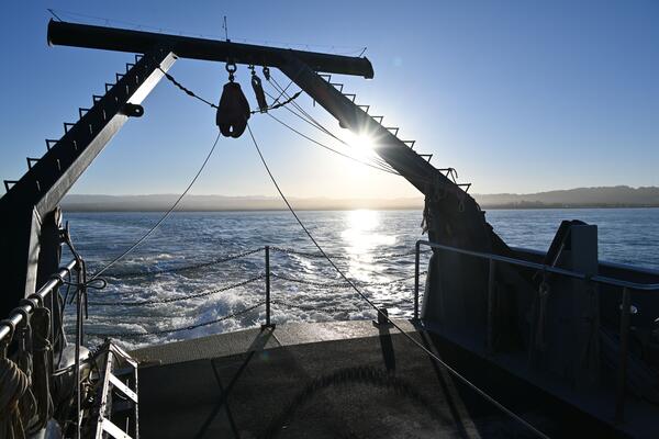
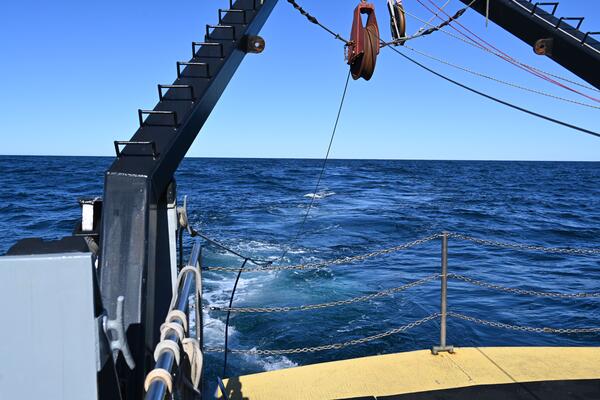
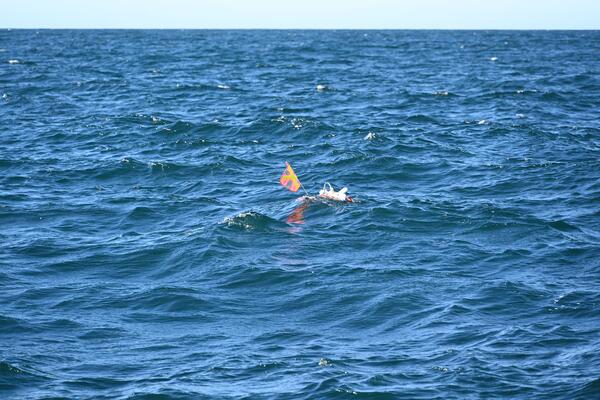
Mendocino RROBS Retrieval
A magnitude 7.0 earthquake ruptured the Mendocino Transform Fault offshore Northern California on December 5, 2024. The USGS and colleagues from the Woods Hole Oceanographic Institution’s Ocean Bottom Seismic Instrument Center deployed our new fleet of rapid response ocean bottom seismographs just 11 days later—the fastest response in U.S. history.
A magnitude 7.0 earthquake ruptured the Mendocino Transform Fault offshore Northern California on December 5, 2024. The USGS and colleagues from the Woods Hole Oceanographic Institution’s Ocean Bottom Seismic Instrument Center deployed our new fleet of rapid response ocean bottom seismographs just 11 days later—the fastest response in U.S. history.
Science and Products
Cascadia Subduction Zone Marine Geohazards
Societal Issue: Uncertainty related to rupture extent, slip distribution, and recurrence of past subduction megathrust earthquakes in the Pacific Northwest (northern CA, OR, WA, and southern BC) leads to ambiguity in earthquake and tsunami hazard assessments and hinders our ability to prepare for future events.
By
Natural Hazards Mission Area, Coastal and Marine Hazards and Resources Program, Pacific Coastal and Marine Science Center, Santa Cruz Core Scanning Laboratory, Santa Cruz Core Laboratories, Santa Cruz Core Splitting Laboratory, Deep Sea Exploration, Mapping and Characterization, Subduction Zone Science
The Mid-Atlantic Resource Imaging Experiment (MATRIX)
In late August 2018, scientists and technical staff from the USGS Coastal and Marine Hazards and Resources Program completed the acquisition of over 2000 km of multichannel seismic (MCS) data as part of the Mid-Atlantic Resource Imaging Experiment (MATRIX) conducted aboard the R/V Hugh R. Sharp. The seismic program was led by the USGS Gas Hydrates Project and was sponsored by the USGS, the U.S...
Mendocino RROBS Retrieval
A magnitude 7.0 earthquake ruptured the Mendocino Transform Fault offshore Northern California on December 5, 2024. The USGS and colleagues from the Woods Hole Oceanographic Institution’s Ocean Bottom Seismic Instrument Center deployed our new fleet of rapid response ocean bottom seismographs just 11 days later—the fastest response in U.S. history.
A magnitude 7.0 earthquake ruptured the Mendocino Transform Fault offshore Northern California on December 5, 2024. The USGS and colleagues from the Woods Hole Oceanographic Institution’s Ocean Bottom Seismic Instrument Center deployed our new fleet of rapid response ocean bottom seismographs just 11 days later—the fastest response in U.S. history.