
A Common Murre feeds its chick a capelin at the Gull Island breeding colony in Kachemak Bay, Alaska. Capelin are an important, energy rich forage fish for many marine predators.
Available here are tracking data for the common murre, a seabird species that is found in regions of the North Pacific and Atlantic oceans, often in dense breeding colonies on cliffs and in large flocks on the water. These data were collected to better understand the migratory patterns of this species in the North Pacific Ocean and Chukchi Sea.
Return to Ecosystems >> Wildlife Tracking Data Collection
USGS Alaska Science Center scientists collect data from wildlife tracking devices to: determine locations of animals throughout their annual cycles, understand patterns of habitat use, quantify time spent on various behaviors, and identify geographic areas repeatedly used by wildlife that may indicate sites of importance to species and populations. Tracking data from other wildlife species can be found at: https://doi.org/10.5066/P9VYSWEH
Tracking Maps
Media

Sources/Usage: Public Domain. View Media Details
(Credit: David Douglas, USGS)
Common Murre Tracking Maps
These webpages contain five different types of browse maps and other visualizations of the tracking data.
- Maps (Animated, Static, Interactive, and Google Earth)
- Summary graphs of the data: where, when, duration
- Seabirds Tagged Animal Movement Explorer interactive visualization tool
- Note: These maps serve only as a depiction of the geographic content of the specific data provided and may be inappropriate for inferences and interpretation outside the intent of the original study. For example, maps may portray only certain ages, sexes, limited numbers of animals or variable tracking duration and start times that may limit inference for other questions. Users are advised to read the publication(s) and data set metadata associated with these maps to understand appropriate use and data limitations.
Data Packages
Argos Satellite Telemetry Data
These data packages contain the data collected from satellite transmitters attached to free-ranging animals. The packages include both raw and processed location and sensor data. The raw data includes data as originally retrieved from the Argos System. The processed data have been filtered for location plausibility, and sensor data have been decoded into standard measurement units. For most users, the processed data will be preferred.
NOTE: Processed data contains both plausible (DAF_Filter=0) and implausible (DAF_Filter=1) locations as indicated by the column “Location_DAF_filter”. Before using these data, we recommend excluding locations flagged as implausible or apply an alternative filtering method of your choice.
- Processed Data [Metadata] [Data Download, 4MB zip]
- Raw Data [Metadata] [Data Download, 4MB zip]
- README
- View ScienceBase Data Release
Suggested Citation
Hatch, S.A., Meyers, P.M., Mulcahy, D.M., Douglas, D.C., 2020, Tracking data for Common murres (Uria aalge) (ver 1.0, August 2020): U.S. Geological Survey data release, https://doi.org/10.5066/P9SOW6V2
Below are other science projects associated with Common Murre.

Seabirds and Forage Fish Ecology
Alaska's coastal and offshore waters provide foraging habitat for an estimated 100 million birds comprising more than 90 different species; from loons and seaducks that nest inland, to petrels and puffins that breed on islands off shore. All these birds depend on the sea to provide a wide variety of food types— from clams, crabs and urchins nearshore— to krill, forage fish, and squid offshore. The...
Below are multimedia items associated with this project.
Filter Total Items: 22

Common Murre feeds chick
A Common Murre feeds its chick a capelin at the Gull Island breeding colony in Kachemak Bay, Alaska. Capelin are an important, energy rich forage fish for many marine predators.

Melanistic Common Murre flies above Gull Island
A melanistic (all dark) Common Murre flies above the Gull Island breeding colony in Kachemak Bay, Alaska, 2018. See related paper published in the Marine Ornithology: Journal of Seabird Research and Conservation at: http://www.marineornithology.org/PDF/50_2/50_2_225-227.pdf.
A melanistic (all dark) Common Murre flies above the Gull Island breeding colony in Kachemak Bay, Alaska, 2018. See related paper published in the Marine Ornithology: Journal of Seabird Research and Conservation at: http://www.marineornithology.org/PDF/50_2/50_2_225-227.pdf.

Common Murre holding a capelin
A Common Murre holding a capelin at a breeding colony on Gull Island, in Kachemak Bay, Alaska. Capelin are an important, energy rich forage fish for many marine predators.
A Common Murre holding a capelin at a breeding colony on Gull Island, in Kachemak Bay, Alaska. Capelin are an important, energy rich forage fish for many marine predators.

Common Murres with Pacific herring
Common Murres holding Pacific herring at their breeding colony on Gull Island.
Common Murres holding Pacific herring at their breeding colony on Gull Island.

Common Murres on Gull Island, Kachemak Bay, Alaska
Common Murres on Gull Island, Kachemak Bay, AlaskaCommon Murres nest along cliff edges and on the top of Gull Island in Kachemak Bay, Alaska.
Common Murres on Gull Island, Kachemak Bay, Alaska
Common Murres on Gull Island, Kachemak Bay, AlaskaCommon Murres nest along cliff edges and on the top of Gull Island in Kachemak Bay, Alaska.

Common Murre with a Northern Ronquil
A Common Murre holds a Northern Ronquil in its bill. Photo taken at Gull Island in Kachemak Bay, Alaska.
A Common Murre holds a Northern Ronquil in its bill. Photo taken at Gull Island in Kachemak Bay, Alaska.

Two Common Murre chicks
Two Common Murre chicks on rock ledge at Gull Island, Alaska.
Two Common Murre chicks on rock ledge at Gull Island, Alaska.

Melanistic Common Murre at its nesting site
A melanistic (all dark) Common Murre at its nesting site on Gull Island in Kachemak Bay, Alaska, 2019. See related paper published in the Marine Ornithology: Journal of Seabird Research and Conservation at: http://www.marineornithology.org/PDF/50_2/50_2_225-227.pdf.
A melanistic (all dark) Common Murre at its nesting site on Gull Island in Kachemak Bay, Alaska, 2019. See related paper published in the Marine Ornithology: Journal of Seabird Research and Conservation at: http://www.marineornithology.org/PDF/50_2/50_2_225-227.pdf.

A Common Murre holds a Pacific sand lance near Gull Island in Alaska
A Common Murre holds a Pacific sand lance near Gull Island in AlaskaNorthern Fulmars, Black-legged Kittiwakes, and Common Murres have all been tested for and contained harmful algal bloom (HAB) toxins. Since 2015, the USGS has worked with a variety of stakeholders to develop testing methods and research projects to better understand the geographic extent, timing and impacts of algal toxins in Alaska marine ecosystems.

Close up of Common Murre sitting on egg at breeding colony on Gull Island
Close up of Common Murre sitting on egg at breeding colony on Gull IslandClose up of Common Murre sitting on egg at breeding colony on Gull Island in Kachemak Bay, Alaska. There are two other murres in the back ground.
Close up of Common Murre sitting on egg at breeding colony on Gull Island
Close up of Common Murre sitting on egg at breeding colony on Gull IslandClose up of Common Murre sitting on egg at breeding colony on Gull Island in Kachemak Bay, Alaska. There are two other murres in the back ground.

Common Murre next to egg at breeding colony on Gull Island, Alaska
Common Murre next to egg at breeding colony on Gull Island, AlaskaCommon Murre next to egg at breeding colony on Gull Island, in Kachemak Bay, Alaska.
Common Murre next to egg at breeding colony on Gull Island, Alaska
Common Murre next to egg at breeding colony on Gull Island, AlaskaCommon Murre next to egg at breeding colony on Gull Island, in Kachemak Bay, Alaska.

Skinny Common Murre with keel protruding
Skinny Common Murre with keel protruding. Lower Cook Inlet, Alaska
Skinny Common Murre with keel protruding. Lower Cook Inlet, Alaska
Skinny Common Murre with keel protruding (second from the left)
Skinny Common Murre with keel protruding (second from the left)Skinny Common Murre with keel protruding (second from the left) contrasted by normal murres. Lower Cook Inlet, Alaska.
Skinny Common Murre with keel protruding (second from the left)
Skinny Common Murre with keel protruding (second from the left)Skinny Common Murre with keel protruding (second from the left) contrasted by normal murres. Lower Cook Inlet, Alaska.

Melanistic Common Murre flies near its colony
A melanistic (all dark) Common Murre flies above its colony on Gull Island in Kachemak Bay, Alaska, 2018. See related paper published in the Marine Ornithology: Journal of Seabird Research and Conservation at: http://www.marineornithology.org/PDF/50_2/50_2_225-227.pdf.
A melanistic (all dark) Common Murre flies above its colony on Gull Island in Kachemak Bay, Alaska, 2018. See related paper published in the Marine Ornithology: Journal of Seabird Research and Conservation at: http://www.marineornithology.org/PDF/50_2/50_2_225-227.pdf.

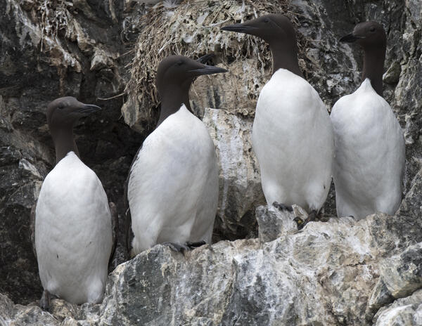
Common Murres at breeding colony - four murres have bills open
Common Murres at breeding colony - four murres have bills openCommon Murres at their breeding colony on Gull Island, Kachemak Bay, Alaska. Four murres have bills open. One sitting on egg.
Common Murres at breeding colony - four murres have bills open
Common Murres at breeding colony - four murres have bills openCommon Murres at their breeding colony on Gull Island, Kachemak Bay, Alaska. Four murres have bills open. One sitting on egg.

Melanistic Common Murre on Gull Island
A melanistic (all dark) Common Murre stands near the base of the Gull Island breeding colony in Kachemak Bay, Alaska, 2017. See related paper published in the Marine Ornithology: Journal of Seabird Research and Conservation at: http://www.marineornithology.org/PDF/50_2/50_2_225-227.pdf.
A melanistic (all dark) Common Murre stands near the base of the Gull Island breeding colony in Kachemak Bay, Alaska, 2017. See related paper published in the Marine Ornithology: Journal of Seabird Research and Conservation at: http://www.marineornithology.org/PDF/50_2/50_2_225-227.pdf.

Common Murres at breeding colony, Alaska-close up of egg
Common Murres at breeding colony, Alaska-close up of eggCommon Murres at their breeding colony on Gull Island, Kachemak Bay, Alaska. One of the murres standing next to egg.
Common Murres at breeding colony, Alaska-close up of egg
Common Murres at breeding colony, Alaska-close up of eggCommon Murres at their breeding colony on Gull Island, Kachemak Bay, Alaska. One of the murres standing next to egg.

Tony DeGange searches for Common Murre carcasses
Retired USGS biologist Tony DeGange searches for Common Murre carcasses along the Alaska Peninsula following the massive die-off of murres in 2015/2016. Puale Bay, Alaska Peninsula
Retired USGS biologist Tony DeGange searches for Common Murre carcasses along the Alaska Peninsula following the massive die-off of murres in 2015/2016. Puale Bay, Alaska Peninsula

A Common Murre carcass decomposes
A Common Murre carcass decomposes along the Alaska Peninsula following the massive die-off of murres in 2015/2016. Portage Bay, Alaska Peninsula.
A Common Murre carcass decomposes along the Alaska Peninsula following the massive die-off of murres in 2015/2016. Portage Bay, Alaska Peninsula.
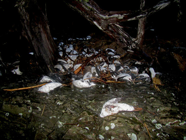
Thousands of Common Murre carcasses on beaches in Pigot Bay
Thousands of Common Murre carcasses on beaches in Pigot BayThousands of Common Murre carcasses piled up on beaches in Pigot Bay following the massive die-off of murres in 2015/2016.
Thousands of Common Murre carcasses on beaches in Pigot Bay
Thousands of Common Murre carcasses on beaches in Pigot BayThousands of Common Murre carcasses piled up on beaches in Pigot Bay following the massive die-off of murres in 2015/2016.
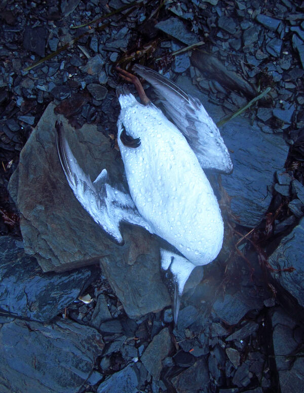
A dead Common Murre found on the beach in Prince William Sound
A dead Common Murre found on the beach in Prince William SoundA dead Common Murre found on the beach in Prince William Sound on Jan 7, 2016. This bird was part of the large die-off of Common Murres across the Gulf of Alaska in 2015-2016.
Available here are tracking data for the common murre, a seabird species that is found in regions of the North Pacific and Atlantic oceans, often in dense breeding colonies on cliffs and in large flocks on the water. These data were collected to better understand the migratory patterns of this species in the North Pacific Ocean and Chukchi Sea.
Return to Ecosystems >> Wildlife Tracking Data Collection
USGS Alaska Science Center scientists collect data from wildlife tracking devices to: determine locations of animals throughout their annual cycles, understand patterns of habitat use, quantify time spent on various behaviors, and identify geographic areas repeatedly used by wildlife that may indicate sites of importance to species and populations. Tracking data from other wildlife species can be found at: https://doi.org/10.5066/P9VYSWEH
Tracking Maps
Media
Sources/Usage: Public Domain. View Media Details
(Credit: David Douglas, USGS)
Common Murre Tracking Maps
These webpages contain five different types of browse maps and other visualizations of the tracking data.
- Maps (Animated, Static, Interactive, and Google Earth)
- Summary graphs of the data: where, when, duration
- Seabirds Tagged Animal Movement Explorer interactive visualization tool
- Note: These maps serve only as a depiction of the geographic content of the specific data provided and may be inappropriate for inferences and interpretation outside the intent of the original study. For example, maps may portray only certain ages, sexes, limited numbers of animals or variable tracking duration and start times that may limit inference for other questions. Users are advised to read the publication(s) and data set metadata associated with these maps to understand appropriate use and data limitations.
Data Packages
Argos Satellite Telemetry Data
These data packages contain the data collected from satellite transmitters attached to free-ranging animals. The packages include both raw and processed location and sensor data. The raw data includes data as originally retrieved from the Argos System. The processed data have been filtered for location plausibility, and sensor data have been decoded into standard measurement units. For most users, the processed data will be preferred.
NOTE: Processed data contains both plausible (DAF_Filter=0) and implausible (DAF_Filter=1) locations as indicated by the column “Location_DAF_filter”. Before using these data, we recommend excluding locations flagged as implausible or apply an alternative filtering method of your choice.
- Processed Data [Metadata] [Data Download, 4MB zip]
- Raw Data [Metadata] [Data Download, 4MB zip]
- README
- View ScienceBase Data Release
Suggested Citation
Hatch, S.A., Meyers, P.M., Mulcahy, D.M., Douglas, D.C., 2020, Tracking data for Common murres (Uria aalge) (ver 1.0, August 2020): U.S. Geological Survey data release, https://doi.org/10.5066/P9SOW6V2
Below are other science projects associated with Common Murre.
Seabirds and Forage Fish Ecology
Alaska's coastal and offshore waters provide foraging habitat for an estimated 100 million birds comprising more than 90 different species; from loons and seaducks that nest inland, to petrels and puffins that breed on islands off shore. All these birds depend on the sea to provide a wide variety of food types— from clams, crabs and urchins nearshore— to krill, forage fish, and squid offshore. The...
Below are multimedia items associated with this project.
Filter Total Items: 22
Common Murre feeds chick
A Common Murre feeds its chick a capelin at the Gull Island breeding colony in Kachemak Bay, Alaska. Capelin are an important, energy rich forage fish for many marine predators.
A Common Murre feeds its chick a capelin at the Gull Island breeding colony in Kachemak Bay, Alaska. Capelin are an important, energy rich forage fish for many marine predators.
Melanistic Common Murre flies above Gull Island
A melanistic (all dark) Common Murre flies above the Gull Island breeding colony in Kachemak Bay, Alaska, 2018. See related paper published in the Marine Ornithology: Journal of Seabird Research and Conservation at: http://www.marineornithology.org/PDF/50_2/50_2_225-227.pdf.
A melanistic (all dark) Common Murre flies above the Gull Island breeding colony in Kachemak Bay, Alaska, 2018. See related paper published in the Marine Ornithology: Journal of Seabird Research and Conservation at: http://www.marineornithology.org/PDF/50_2/50_2_225-227.pdf.
Common Murre holding a capelin
A Common Murre holding a capelin at a breeding colony on Gull Island, in Kachemak Bay, Alaska. Capelin are an important, energy rich forage fish for many marine predators.
A Common Murre holding a capelin at a breeding colony on Gull Island, in Kachemak Bay, Alaska. Capelin are an important, energy rich forage fish for many marine predators.
Common Murres with Pacific herring
Common Murres holding Pacific herring at their breeding colony on Gull Island.
Common Murres holding Pacific herring at their breeding colony on Gull Island.
Common Murres on Gull Island, Kachemak Bay, Alaska
Common Murres on Gull Island, Kachemak Bay, AlaskaCommon Murres nest along cliff edges and on the top of Gull Island in Kachemak Bay, Alaska.
Common Murres on Gull Island, Kachemak Bay, Alaska
Common Murres on Gull Island, Kachemak Bay, AlaskaCommon Murres nest along cliff edges and on the top of Gull Island in Kachemak Bay, Alaska.
Common Murre with a Northern Ronquil
A Common Murre holds a Northern Ronquil in its bill. Photo taken at Gull Island in Kachemak Bay, Alaska.
A Common Murre holds a Northern Ronquil in its bill. Photo taken at Gull Island in Kachemak Bay, Alaska.
Two Common Murre chicks
Two Common Murre chicks on rock ledge at Gull Island, Alaska.
Two Common Murre chicks on rock ledge at Gull Island, Alaska.
Melanistic Common Murre at its nesting site
A melanistic (all dark) Common Murre at its nesting site on Gull Island in Kachemak Bay, Alaska, 2019. See related paper published in the Marine Ornithology: Journal of Seabird Research and Conservation at: http://www.marineornithology.org/PDF/50_2/50_2_225-227.pdf.
A melanistic (all dark) Common Murre at its nesting site on Gull Island in Kachemak Bay, Alaska, 2019. See related paper published in the Marine Ornithology: Journal of Seabird Research and Conservation at: http://www.marineornithology.org/PDF/50_2/50_2_225-227.pdf.
A Common Murre holds a Pacific sand lance near Gull Island in Alaska
A Common Murre holds a Pacific sand lance near Gull Island in AlaskaNorthern Fulmars, Black-legged Kittiwakes, and Common Murres have all been tested for and contained harmful algal bloom (HAB) toxins. Since 2015, the USGS has worked with a variety of stakeholders to develop testing methods and research projects to better understand the geographic extent, timing and impacts of algal toxins in Alaska marine ecosystems.
Close up of Common Murre sitting on egg at breeding colony on Gull Island
Close up of Common Murre sitting on egg at breeding colony on Gull IslandClose up of Common Murre sitting on egg at breeding colony on Gull Island in Kachemak Bay, Alaska. There are two other murres in the back ground.
Close up of Common Murre sitting on egg at breeding colony on Gull Island
Close up of Common Murre sitting on egg at breeding colony on Gull IslandClose up of Common Murre sitting on egg at breeding colony on Gull Island in Kachemak Bay, Alaska. There are two other murres in the back ground.
Common Murre next to egg at breeding colony on Gull Island, Alaska
Common Murre next to egg at breeding colony on Gull Island, AlaskaCommon Murre next to egg at breeding colony on Gull Island, in Kachemak Bay, Alaska.
Common Murre next to egg at breeding colony on Gull Island, Alaska
Common Murre next to egg at breeding colony on Gull Island, AlaskaCommon Murre next to egg at breeding colony on Gull Island, in Kachemak Bay, Alaska.
Skinny Common Murre with keel protruding
Skinny Common Murre with keel protruding. Lower Cook Inlet, Alaska
Skinny Common Murre with keel protruding. Lower Cook Inlet, Alaska
Skinny Common Murre with keel protruding (second from the left)
Skinny Common Murre with keel protruding (second from the left)Skinny Common Murre with keel protruding (second from the left) contrasted by normal murres. Lower Cook Inlet, Alaska.
Skinny Common Murre with keel protruding (second from the left)
Skinny Common Murre with keel protruding (second from the left)Skinny Common Murre with keel protruding (second from the left) contrasted by normal murres. Lower Cook Inlet, Alaska.
Melanistic Common Murre flies near its colony
A melanistic (all dark) Common Murre flies above its colony on Gull Island in Kachemak Bay, Alaska, 2018. See related paper published in the Marine Ornithology: Journal of Seabird Research and Conservation at: http://www.marineornithology.org/PDF/50_2/50_2_225-227.pdf.
A melanistic (all dark) Common Murre flies above its colony on Gull Island in Kachemak Bay, Alaska, 2018. See related paper published in the Marine Ornithology: Journal of Seabird Research and Conservation at: http://www.marineornithology.org/PDF/50_2/50_2_225-227.pdf.
Common Murres at breeding colony - four murres have bills open
Common Murres at breeding colony - four murres have bills openCommon Murres at their breeding colony on Gull Island, Kachemak Bay, Alaska. Four murres have bills open. One sitting on egg.
Common Murres at breeding colony - four murres have bills open
Common Murres at breeding colony - four murres have bills openCommon Murres at their breeding colony on Gull Island, Kachemak Bay, Alaska. Four murres have bills open. One sitting on egg.
Melanistic Common Murre on Gull Island
A melanistic (all dark) Common Murre stands near the base of the Gull Island breeding colony in Kachemak Bay, Alaska, 2017. See related paper published in the Marine Ornithology: Journal of Seabird Research and Conservation at: http://www.marineornithology.org/PDF/50_2/50_2_225-227.pdf.
A melanistic (all dark) Common Murre stands near the base of the Gull Island breeding colony in Kachemak Bay, Alaska, 2017. See related paper published in the Marine Ornithology: Journal of Seabird Research and Conservation at: http://www.marineornithology.org/PDF/50_2/50_2_225-227.pdf.
Common Murres at breeding colony, Alaska-close up of egg
Common Murres at breeding colony, Alaska-close up of eggCommon Murres at their breeding colony on Gull Island, Kachemak Bay, Alaska. One of the murres standing next to egg.
Common Murres at breeding colony, Alaska-close up of egg
Common Murres at breeding colony, Alaska-close up of eggCommon Murres at their breeding colony on Gull Island, Kachemak Bay, Alaska. One of the murres standing next to egg.
Tony DeGange searches for Common Murre carcasses
Retired USGS biologist Tony DeGange searches for Common Murre carcasses along the Alaska Peninsula following the massive die-off of murres in 2015/2016. Puale Bay, Alaska Peninsula
Retired USGS biologist Tony DeGange searches for Common Murre carcasses along the Alaska Peninsula following the massive die-off of murres in 2015/2016. Puale Bay, Alaska Peninsula
A Common Murre carcass decomposes
A Common Murre carcass decomposes along the Alaska Peninsula following the massive die-off of murres in 2015/2016. Portage Bay, Alaska Peninsula.
A Common Murre carcass decomposes along the Alaska Peninsula following the massive die-off of murres in 2015/2016. Portage Bay, Alaska Peninsula.
Thousands of Common Murre carcasses on beaches in Pigot Bay
Thousands of Common Murre carcasses on beaches in Pigot BayThousands of Common Murre carcasses piled up on beaches in Pigot Bay following the massive die-off of murres in 2015/2016.
Thousands of Common Murre carcasses on beaches in Pigot Bay
Thousands of Common Murre carcasses on beaches in Pigot BayThousands of Common Murre carcasses piled up on beaches in Pigot Bay following the massive die-off of murres in 2015/2016.
A dead Common Murre found on the beach in Prince William Sound
A dead Common Murre found on the beach in Prince William SoundA dead Common Murre found on the beach in Prince William Sound on Jan 7, 2016. This bird was part of the large die-off of Common Murres across the Gulf of Alaska in 2015-2016.