
Key considerations to accurately predict tidal marsh longevity
A recent study provides key considerations about modeling the timeline of tidal marsh longevity. These timelines can help resource managers envision what future marsh conditions may look like, informing current and long-term adaptive management strategies.
Issue
Tidal marshes are highly productive ecosystems that benefit humans and wildlife. However, tidal marshes are also under threat from increasing rates of sea level rise. Rates of relative sea level rise (RSLR), a term that includes the effects of changing land elevation, are much higher in the Chesapeake Bay than the global average. As a result, resource managers in the Bay are faced with the challenge of determining how best to preserve the estuary’s marshes given unknown future conditions. Using models to predict the fate of marshes under potential RSLR scenarios is one tool to help address this challenge. Yet with a range of modeling options available, it can be difficult for managers to determine which is most appropriate to use or on which output they should base their management decisions.
USGS Study
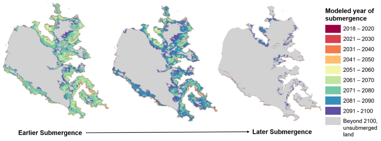
With multiple marsh models to choose from, there is a need to understand how their output compares and how it is affected by data quality. To address this need, USGS researchers used different models to estimate marsh longevity under four RSLR scenarios through year 2100 and examined similarities and differences among each model’s results. The study focused on Eastern Neck Island National Wildlife Refuge located within the Chesapeake Bay in Kent County, Maryland, USA.
Major findings
The study revealed that variation in the predicted timeframe over which marsh submergence would occur depended on both the model and elevation data used.
- All model results agreed that RSLR would lead to marsh conversion to open water on Eastern Neck Island National Wildlife Refuge between 2070 and 2100. However, the specific year of submergence varied among models and depended on initial marsh elevation and rate of accumulation of organic material and sediment (known as ‘accretion’).
- Uncorrected elevation data can give biased estimates of marsh longevity. For example, LiDAR, which uses lasers to measure land height, can make the elevation of densely vegetated marshes appear higher than they really are because the lasers fail to penetrate to the ground. In this study, corrected elevation data predicted marsh submergence 7 years earlier, on average, than models with uncorrected data.
- As predictions of when marsh submergence will occur can vary among models, it may be difficult to determine which model’s output is most accurate. This difficulty could be addressed by collecting and populating models with site-specific field data when possible, such as sediment core samples that can enable the estimation of accretion rates.
- There are many tradeoffs to each modeling approach, including data availability and quality, time availability, and acceptable levels of uncertainty. Running models with limited data or in the absence of calibration data could increase variation and uncertainty in model output.
Management Applications
Modeling marsh longevity under various RSLR scenarios can help resource managers envision what future conditions may look like, informing current and long-term adaptive management strategies. However, users should consider the numerous factors that can influence the application of these models. For example, since the specific model selected can influence RSLR projections, users may reach different conclusions depending on what model they use. Thus, users should consider examining outputs from multiple models and approaches so that management decisions are not based on only one model. If the output from multiple models aligns, this can increase confidence in what the future state of a marsh may look like. In addition, since each model explored in this study differed in the level of expertise needed to run it and interpret results, users should consider what their capabilities are before selecting models to use. Lastly, the approaches presented in this study are forward-looking models that describe potential conditions rather than predicted outcomes. Given the many tradeoffs to each model type, users should evaluate their management questions, overall goals, the amount of effort involved in model parameterization, and the amount of uncertainty in the model that they are willing to accept prior to selecting their modeling approach.
For more information
The full study is published online with open access: https://doi.org/10.1007/s12237-025-01559-4.
A recent study provides key considerations about modeling the timeline of tidal marsh longevity. These timelines can help resource managers envision what future marsh conditions may look like, informing current and long-term adaptive management strategies.
Issue
Tidal marshes are highly productive ecosystems that benefit humans and wildlife. However, tidal marshes are also under threat from increasing rates of sea level rise. Rates of relative sea level rise (RSLR), a term that includes the effects of changing land elevation, are much higher in the Chesapeake Bay than the global average. As a result, resource managers in the Bay are faced with the challenge of determining how best to preserve the estuary’s marshes given unknown future conditions. Using models to predict the fate of marshes under potential RSLR scenarios is one tool to help address this challenge. Yet with a range of modeling options available, it can be difficult for managers to determine which is most appropriate to use or on which output they should base their management decisions.
USGS Study
With multiple marsh models to choose from, there is a need to understand how their output compares and how it is affected by data quality. To address this need, USGS researchers used different models to estimate marsh longevity under four RSLR scenarios through year 2100 and examined similarities and differences among each model’s results. The study focused on Eastern Neck Island National Wildlife Refuge located within the Chesapeake Bay in Kent County, Maryland, USA.
Major findings
The study revealed that variation in the predicted timeframe over which marsh submergence would occur depended on both the model and elevation data used.
- All model results agreed that RSLR would lead to marsh conversion to open water on Eastern Neck Island National Wildlife Refuge between 2070 and 2100. However, the specific year of submergence varied among models and depended on initial marsh elevation and rate of accumulation of organic material and sediment (known as ‘accretion’).
- Uncorrected elevation data can give biased estimates of marsh longevity. For example, LiDAR, which uses lasers to measure land height, can make the elevation of densely vegetated marshes appear higher than they really are because the lasers fail to penetrate to the ground. In this study, corrected elevation data predicted marsh submergence 7 years earlier, on average, than models with uncorrected data.
- As predictions of when marsh submergence will occur can vary among models, it may be difficult to determine which model’s output is most accurate. This difficulty could be addressed by collecting and populating models with site-specific field data when possible, such as sediment core samples that can enable the estimation of accretion rates.
- There are many tradeoffs to each modeling approach, including data availability and quality, time availability, and acceptable levels of uncertainty. Running models with limited data or in the absence of calibration data could increase variation and uncertainty in model output.
Management Applications
Modeling marsh longevity under various RSLR scenarios can help resource managers envision what future conditions may look like, informing current and long-term adaptive management strategies. However, users should consider the numerous factors that can influence the application of these models. For example, since the specific model selected can influence RSLR projections, users may reach different conclusions depending on what model they use. Thus, users should consider examining outputs from multiple models and approaches so that management decisions are not based on only one model. If the output from multiple models aligns, this can increase confidence in what the future state of a marsh may look like. In addition, since each model explored in this study differed in the level of expertise needed to run it and interpret results, users should consider what their capabilities are before selecting models to use. Lastly, the approaches presented in this study are forward-looking models that describe potential conditions rather than predicted outcomes. Given the many tradeoffs to each model type, users should evaluate their management questions, overall goals, the amount of effort involved in model parameterization, and the amount of uncertainty in the model that they are willing to accept prior to selecting their modeling approach.
For more information
The full study is published online with open access: https://doi.org/10.1007/s12237-025-01559-4.