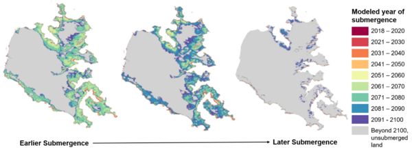
Joel is a research ecologist with the coastal processes group currently examining and modelling biotic and abiotic processes controlling marsh upland boundary migration.
Joel's background is in environmental sciences and mathematics, with a focus on using modeling to investigate non-linear dynamics in ecosystems. He has a background in vegetation modified transport processes and much of my work focuses on examining the stability and resilience of seagrass (Zostera marina) to environmental drivers/stressors.
Joel's research interests are varied but tend to focus on ecogeomorphic and ecohydrologic feedbacks mechanisms and the emergence of alternate state dynamics, complex networks, human-environment interactions,the population-water-food nexus, inequality, transport processes, sediment dynamics and noise induced phenomena among others
Science and Products
Progress Through Partnerships - Chesapeake Bay Vertical Land Motion Project
The Response of Coastal Wetlands to Sea-level Rise: Understanding how Macroscale Drivers Influence Local Processes and Feedbacks
The response of coastal wetlands to sea-level rise: Understanding how macroscale drivers influence local processes and feedbacks
Virginia Coast Reserve Long Term Ecological Research VII
Seagrass Vulnerability to Environmental Conditions Under Changing Temperature Regimes
Vulnerability Assessment of Available Habitat for Wintering Black Ducks within the Refuge System in the Chesapeake Bay
Environmental and Vegetation Data from Marsh-Forest Transgression Experiment at Blackwater National Wildlife Refuge, MD, USA
Water levels (November 11 2016 through November 11 2017) for four wells and Light intensity data (October 1 2015 through September 2019): from marsh to upland forest, for Moneystump Marsh, Blackwater National Wildlife Refuge, Maryland
Mangrove Elevation and Species' Responses to Sea-level Rise Across Pohnpei, Federated States of Micronesia (ver. 1.1, December 2021)
GPS data from 2019 and 2020 campaigns in the Chesapeake Bay region towards quantifying vertical land motions
Mangroves provide blue carbon ecological value at a low freshwater cost
Variability in marsh migration potential determined by topographic rather than anthropogenic constraints in the Chesapeake Bay region
Experimental tree mortality does not induce marsh transgression in a Chesapeake Bay low-lying coastal forest
Modeling marsh dynamics using a 3-D coupled wave-flow-sediment model
Quantifying slopes as a driver of forest to marsh conversion using geospatial techniques: Application to Chesapeake Bay coastal-plain, USA
Mangrove species’ response to sea-level rise across Pohnpei, Federated States of Micronesia
Modelling marsh-forest boundary transgression in response to storms and sea-level rise
Impacts of seagrass dynamics on the coupled long-term evolution of barrier-marsh-bay systems
Global virtual water trade and the hydrological cycle: Patterns, drivers, and socio-environmental impacts
The Global food‐energy‐water nexus
Exploring the impacts of seagrass on coupled marsh-tidal flat morphodynamics
Science and Products
- Science
Progress Through Partnerships - Chesapeake Bay Vertical Land Motion Project
Chesapeake Bay region has the highest rate of relative sea-level rise on the Atlantic Coast of the United States, and data indicate that vertical land motion in the form of subsidence has been responsible for more than half the relative sea-level rise measured in the Chesapeake Bay region. The Chesapeake Bay Vertical Land Motion Project is a cooperative effort between the USGS and our many...The Response of Coastal Wetlands to Sea-level Rise: Understanding how Macroscale Drivers Influence Local Processes and Feedbacks
The purpose of this work is to advance our understanding of how coastal wetland responses to sea-level rise (SLR) within the conterminous United States are likely to vary as a function of local, regional, and macroscale drivers, including climate. Based on our interactions with managers and decision makers, as well as our knowledge of the current state of the science, we propose to: (a) conduct a...The response of coastal wetlands to sea-level rise: Understanding how macroscale drivers influence local processes and feedbacks
The purpose of this work is to advance our understanding of how coastal wetland responses to SLR within the conterminous United States are likely to vary as a function of local, regional, and macroscale drivers, including climate. Based on our interactions with managers and decision makers, as well as our knowledge of the current state of the science, we propose to (a) conduct a national synoptic...Virginia Coast Reserve Long Term Ecological Research VII
The highly protected Virginia Coast Reserve (VCR) is the largest undeveloped region along the Atlantic seaboard.The VCR is managed by the Nature Conservancy, and was designated a Man and the Biosphere Reserve in 1979, providing a unique environment for which to study coastal impacts of climate change on a variety of coastal ecosystems from barrier islands across back barrier lagoons, mudflats...Seagrass Vulnerability to Environmental Conditions Under Changing Temperature Regimes
Seagrasses are among the most productive ecosystems on the planet. Water quality degradation and direct human disturbance have caused loss of nearly a third of the seagrass habitat worldwide. These threats are exacerbated by stresses associated with a changing global climate. Predicting how seagrass distribution, abundance, and species composition will change in response to increased temperature...Vulnerability Assessment of Available Habitat for Wintering Black Ducks within the Refuge System in the Chesapeake Bay
American black duck (Anas rubripes) utilize inland and tidal freshwater and brackish marshes throughout the Chesapeake Bay and are considered to be an indicator species of the ecosystem’s health. Thus, conserving and increasing black duck habitats will subsequently benefit the general health of the bay. The goal of this study was to create a mechanistic model to determine the amount of... - Data
Environmental and Vegetation Data from Marsh-Forest Transgression Experiment at Blackwater National Wildlife Refuge, MD, USA
We conducted a field experiment at the Moneystump Swamp in the Blackwater National Wildlife Refuge in Dorchester, MD, USA to simulate a natural forest disturbance event (e.g., storm-induced flooding) by inducing the death of established trees (coastal loblolly pine, Pinus taeda) at the marsh-upland forest ecotone. There were three treatment components: Cut- where the trees were cut and removed, GiWater levels (November 11 2016 through November 11 2017) for four wells and Light intensity data (October 1 2015 through September 2019): from marsh to upland forest, for Moneystump Marsh, Blackwater National Wildlife Refuge, Maryland
Water levels in meters from four wells in Moneystump marsh at Blackwater National Wildlife Refuge, MD. Two wells are located in the upland forest; one well is located in the marsh-forest transition zone (ecotone); and one well is located in the marsh. Water depth of the adjacent creek is reported in meters. Data covers the time span from November 11 2016 - November 11 2017. Pressure transducer datMangrove Elevation and Species' Responses to Sea-level Rise Across Pohnpei, Federated States of Micronesia (ver. 1.1, December 2021)
Future sea-level rise poses a risk to mangrove forests. To better understand potential vulnerability, we developed a new numerical model of soil elevation for mangrove forests. We used the model to generate projections of elevation and mangrove forest composition change under four sea-level rise scenarios through 2100 (37, 52, 67, and 117 cm by 2100). We employed a data-driven modeling approach, u - Publications
Filter Total Items: 15
GPS data from 2019 and 2020 campaigns in the Chesapeake Bay region towards quantifying vertical land motions
The Chesapeake Bay is a region along the eastern coast of the United States where sea-level rise is confounded with poorly resolved rates of land subsidence, thus new constraints on vertical land motions (VLM) in the region are warranted. In this paper, we provide a description of two campaign-style Global Positioning System (GPS) datasets, explain the methods used in data collection and validatioMangroves provide blue carbon ecological value at a low freshwater cost
“Blue carbon” wetland vegetation has a limited freshwater requirement. One type, mangroves, utilizes less freshwater during transpiration than adjacent terrestrial ecoregions, equating to only 43% (average) to 57% (potential) of evapotranspiration (ET). Here, we demonstrate that comparative consumptive water use by mangrove vegetation is as much as 2905 kL H2O ha−1 year−1 less than adjacent ecoregVariability in marsh migration potential determined by topographic rather than anthropogenic constraints in the Chesapeake Bay region
Sea level rise (SLR) and saltwater intrusion are driving inland shifts in coastal ecosystems. Here, we make high-resolution (1 m) predictions of land conversion under future SLR scenarios in 81 watersheds surrounding Chesapeake Bay, United States, a hotspot for accelerated SLR and saltwater intrusion. We find that 1050–3748 km2 of marsh could be created by 2100, largely at the expense of forestedExperimental tree mortality does not induce marsh transgression in a Chesapeake Bay low-lying coastal forest
Transgression into adjacent uplands is an important global response of coastal wetlands to accelerated rates of sea level rise. “Ghost forests” mark a signature characteristic of marsh transgression on the landscape, as changes in tidal inundation and salinity cause bordering upland tree mortality, increase light availability, and the emergence of tidal marsh species due to reduced competition. ToModeling marsh dynamics using a 3-D coupled wave-flow-sediment model
Salt marshes are dynamic biogeomorphic systems that respond to external physical factors, including tides, sediment transport, and waves, as well as internal processes such as autochthonous soil formation. Predicting the fate of marshes requires a modeling framework that accounts for these processes in a coupled fashion. In this study, we implement two new marsh dynamic processes in the 3-D COAWSTQuantifying slopes as a driver of forest to marsh conversion using geospatial techniques: Application to Chesapeake Bay coastal-plain, USA
Coastal salt marshes, which provide valuable ecosystem services such as flood mitigation and carbon sequestration, are threatened by rising sea level. In response, these ecosystems migrate landward, converting available upland into salt marsh. In the coastal-plain surrounding Chesapeake Bay, United States, conversion of coastal forest to salt marsh is well-documented and may offset salt marsh lossMangrove species’ response to sea-level rise across Pohnpei, Federated States of Micronesia
Mangrove forests are likely vulnerable to accelerating sea-level rise; however, we lack the tools necessary to understand their future resilience. On the Pacific island of Pohnpei, Federated States of Micronesia, mangroves are habitat to endangered species and provide critical ecosystem services that support local communities. We developed a generalizable modeling framework for mangroves that accoModelling marsh-forest boundary transgression in response to storms and sea-level rise
The lateral extent and vertical stability of salt marshes experiencing rising sea levels depend on interacting drivers and feedbacks with potential for non‐linear behaviors. A two‐dimensional transect model was developed to examine changes in marsh and upland forest lateral extent and to explore controls on marsh inland transgression. Model behavior demonstrates limited and abrupt forest retreat wImpacts of seagrass dynamics on the coupled long-term evolution of barrier-marsh-bay systems
Seagrass provides a wide range of economically and ecologically valuable ecosystem services, with shoreline erosion control often listed as a key service, but can also alter the sediment dynamics and waves within back-barrier bays. Here we incorporate seagrass dynamics into an existing barrier-marsh exploratory model, GEOMBEST++, to examine the coupled interactions of the back-barrier bay with botGlobal virtual water trade and the hydrological cycle: Patterns, drivers, and socio-environmental impacts
The increasing global demand for farmland products is placing unprecedented pressure on the global agricultural system and its water resources. Many regions of the world, that are affected by a chronic water scarcity relative to their population, strongly depend on the import of agricultural commodities and associated embodied (or virtual) water. The globalization of water through virtual water trThe Global food‐energy‐water nexus
Water availability is a major factor constraining humanity's ability to meet the future food and energy needs of a growing and increasingly affluent human population. Water plays an important role in the production of energy, including renewable energy sources and the extraction of unconventional fossil fuels that are expected to become important players in future energy security. The emergent comExploring the impacts of seagrass on coupled marsh-tidal flat morphodynamics
Intertidal coastal environments are prone to changes induced by sea level rise, increases in storminess, temperature, and anthropogenic disturbances. It is unclear how changes in external drivers may affect the dynamics of low energy coastal environments because their response is non-linear, and characterized by many thresholds and discontinuities. As such, process-based modeling of the ecogeomorp