USGS and Partner Efforts to Monitor High River Flow During Summer, 2018 and Potential Effects of Hurricane Florence on the Chesapeake Bay Watershed
Prepared by Scott Phillips and Peter Tango, USGS and Chesapeake Scientific, Technical Analysis, and Reporting (STAR) team, September 12, 2018
Chesapeake Rivers are already above normal prior to Hurricane Florence:
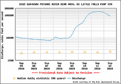
- River flows are already high across the Bay watershed due to recent rains during the weekend of September 8-9 (see Potomac River chart and map below).
- River flow into the Chesapeake set a record for the month of August, at 133,000 cubic feet per second (see graph below).
- River flows to the Chesapeake have been unusually high since May.
- High river flows usually carry more pollutants into the bay and affect salinity levels, which in turn can affect oysters and fish, underwater grasses and other facets of the bay ecosystem.
- More rain from Hurricane Florence is expected particularly in the Virginia portion of the watershed and could have additional effects on the watershed and Bay.


USGS and science partners are enhancing monitoring activities in anticipation of Florence.
- USGS in Virginia, West Virginia, Maryland, and Pennsylvania offices are working with FEMA, States, and localities to deploy real-time rapid deployment gauges and surge sensors in the lower Chesapeake Bay and at inland locations anticipated to have significant community impacts because of Hurricane Florence and the remnants of Hurricane Gordon.
- 24 sites of the Chesapeake Bay Program (CBP) nontidal water-quality network will be sampled in Virginia. Sample collection is expected to begin Friday (9/14) and continue until streamflow dissipates early next week.
- Another 12 monitoring locations will be sampled around Hampton Roads, Virginia, which has an Urban Runoff Network. It is expected that measurements will be made during the entirety of the storm response (that is, Thursday-Saturday).
- Sampling of the Susquehanna River at Conowingo continues. The USGS has been collecting storm samples from the high flows due to rain the weekend of Sept 7-8.
- Crews are ready in all the states for water-quality monitoring if rains from Florence move northward.
- Sampling of tidal waters is occurring every two weeks. Maryland DNR, Old Dominion University, Virginia DEQ, and NOAA are working with the CBP Monitoring Team to coordinate collection of water-quality samples in the Bay and tidal rivers.
For more information:
Real-time River Flow in the Chesapeake Watershed. The most current streamflow conditions in the Mid-Atlantic area are available from the USGS WaterWatch site.
Summary of estimated monthly river flow to the Chesapeake Bay.
Contact Scott Phillips (swphilli@usgs.gov) or Peter Tango (ptango@chesapeakebay.net).

« Return to Chesapeake Bay Activities — Home
Prepared by Scott Phillips and Peter Tango, USGS and Chesapeake Scientific, Technical Analysis, and Reporting (STAR) team, September 12, 2018
Chesapeake Rivers are already above normal prior to Hurricane Florence:
- River flows are already high across the Bay watershed due to recent rains during the weekend of September 8-9 (see Potomac River chart and map below).
- River flow into the Chesapeake set a record for the month of August, at 133,000 cubic feet per second (see graph below).
- River flows to the Chesapeake have been unusually high since May.
- High river flows usually carry more pollutants into the bay and affect salinity levels, which in turn can affect oysters and fish, underwater grasses and other facets of the bay ecosystem.
- More rain from Hurricane Florence is expected particularly in the Virginia portion of the watershed and could have additional effects on the watershed and Bay.


USGS and science partners are enhancing monitoring activities in anticipation of Florence.
- USGS in Virginia, West Virginia, Maryland, and Pennsylvania offices are working with FEMA, States, and localities to deploy real-time rapid deployment gauges and surge sensors in the lower Chesapeake Bay and at inland locations anticipated to have significant community impacts because of Hurricane Florence and the remnants of Hurricane Gordon.
- 24 sites of the Chesapeake Bay Program (CBP) nontidal water-quality network will be sampled in Virginia. Sample collection is expected to begin Friday (9/14) and continue until streamflow dissipates early next week.
- Another 12 monitoring locations will be sampled around Hampton Roads, Virginia, which has an Urban Runoff Network. It is expected that measurements will be made during the entirety of the storm response (that is, Thursday-Saturday).
- Sampling of the Susquehanna River at Conowingo continues. The USGS has been collecting storm samples from the high flows due to rain the weekend of Sept 7-8.
- Crews are ready in all the states for water-quality monitoring if rains from Florence move northward.
- Sampling of tidal waters is occurring every two weeks. Maryland DNR, Old Dominion University, Virginia DEQ, and NOAA are working with the CBP Monitoring Team to coordinate collection of water-quality samples in the Bay and tidal rivers.
For more information:
Real-time River Flow in the Chesapeake Watershed. The most current streamflow conditions in the Mid-Atlantic area are available from the USGS WaterWatch site.
Summary of estimated monthly river flow to the Chesapeake Bay.
Contact Scott Phillips (swphilli@usgs.gov) or Peter Tango (ptango@chesapeakebay.net).

« Return to Chesapeake Bay Activities — Home

