
Snowpack Sublimation - Measurements and Modeling in the Colorado River Basin
Snow is an essential resource in the western United States (U.S.), providing water for drinking, irrigation, industry, energy production, and ecosystems across much of the region. In the mountains of the western U.S., most precipitation falls as snow, which accumulates in seasonal snowpacks that serve as a large natural reservoir.
Snowpack sublimation, which is analogous to evaporation from land or water bodies, represents an important, but poorly quantified, loss of water from the snowpack. Sublimation is one the major uncertainties in runoff forecast models, and is thought to be particularly important during drought years, when water is scarce.
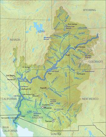
The map on the left shows the Colorado River Basin (CRB). On average, 70 to 85% of annual runoff in the Colorado River Basin originates as mountain snowmelt, which is a critical water supply for Denver, Las Vegas, Phoenix, Tucson, Los Angeles, and San Diego.
The U.S. Geological Survey (USGS) is conducting a study of snowpack sublimation in the CRB as part of the USGS National Water Census program.
The primary goal is to develop sublimation estimates for the CRB using ground-based measurements and moderate-resolution and high-resolution gridded models to inform hydrologic modeling studies, water availability studies, and water use assessments.
The USGS measured meteorological parameters at three sites in the Colorado River Basin near Snow Mountain Ranch, Colorado
Below are other science projects associated with this project.

Rocky Mountain Regional Snowpack Chemistry Monitoring Study

Water, Energy, and Biogeochemical Budgets (WEBB): Loch Vale Watershed
Snow is an essential resource in the western United States (U.S.), providing water for drinking, irrigation, industry, energy production, and ecosystems across much of the region. In the mountains of the western U.S., most precipitation falls as snow, which accumulates in seasonal snowpacks that serve as a large natural reservoir.
Snowpack sublimation, which is analogous to evaporation from land or water bodies, represents an important, but poorly quantified, loss of water from the snowpack. Sublimation is one the major uncertainties in runoff forecast models, and is thought to be particularly important during drought years, when water is scarce.
The map on the left shows the Colorado River Basin (CRB). On average, 70 to 85% of annual runoff in the Colorado River Basin originates as mountain snowmelt, which is a critical water supply for Denver, Las Vegas, Phoenix, Tucson, Los Angeles, and San Diego.
The U.S. Geological Survey (USGS) is conducting a study of snowpack sublimation in the CRB as part of the USGS National Water Census program.
The primary goal is to develop sublimation estimates for the CRB using ground-based measurements and moderate-resolution and high-resolution gridded models to inform hydrologic modeling studies, water availability studies, and water use assessments.
The USGS measured meteorological parameters at three sites in the Colorado River Basin near Snow Mountain Ranch, Colorado
Below are other science projects associated with this project.
Rocky Mountain Regional Snowpack Chemistry Monitoring Study