
Bringing EROS Work to AGU
The American Geophysical Union (AGU) annual meeting brings together at least 25,000 people from around the world to share their research with thousands of abstracts, oral presentations, and both in-person and virtual poster sessions. The gathering takes place December 11–15, 2023, in San Francisco.
Several staff from the USGS Earth Resources Observation and Science (EROS) Center will attend the AGU meeting and present their work.
Land Cover Synergies
The USGS has been mapping land cover for a long time now using Landsat data. An EROS team has been using that data to forecast land cover change and even to estimate land cover from the pre-Landsat past.
The model developed at EROS is called Forecasting Scenarios of Land-Use Change (FORE-SCE), and that’s what Terry Sohl, Acting Branch Chief for the Integrated Science and Applications Branch, is going to be talking about at AGU. “That use of empirical data to support modeling past and potential future land cover change is something that is kind of our bread and butter, and it’s something that we take a lot of pride in,” Sohl said.
Sohl also emphasized that it’s the long timespan of the Landsat archive that makes the land cover mapping work at EROS especially valuable. “We can take that already long-term record from Landsat and extend it out both backward and forward in time.”
EROS has been leading the way at this for some time, but Sohl will also be talking about a new collaboration coming with the USGS Western Geographic Science Center. They are going to work on linking the FORE-SCE model with that center’s Land Use and Carbon Scenario Simulator (LUCAS) model. Sohl explains: “It’s about trying to take the best of both worlds. The FORE-SCE model excels at land use and land cover, but we don’t do carbon and we don’t do some forms of land use change that LUCAS does, like fire. We’re taking our modeling framework and trying to link it up with the LUCAS model to have one more comprehensive model of Earth system change.”
Working Toward Better ET Estimates
The operational Simplified Surface Energy Balance (SSEBop) model, developed at EROS, uses Landsat data to generate actual evapotranspiration (ET) datasets. It does have the limitation of the availability of Landsat data, especially the 8-day repeat time and clouds, so there are some gaps.
Mikael Hiestand, Mendenhall Postdoctoral Fellow, will talk about his project that is working on using an EROS-developed algorithm called the Continuous Change Detection and Classification (CCDC) to fill those gaps. “I’m trying to run Gabriel Senay’s evapotranspiration model [SSEBop] on synthetic Landsat data from the CCDC algorithm,” he said. The model looks for trends, so Hiestand is investigating whether that can be used to make reasonable forecasts.
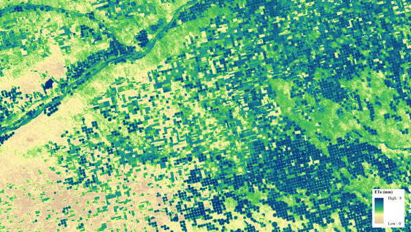
The benefits could be wide-ranging. The resulting product will allow for enhanced drought prediction and will aid decision makers in managing increasingly scarce water resources in the western United States. It could also help ranchers know where to move their cattle. Furthermore, Hiestand says, “In terms of wildfire management, if you can predict how fast a forest is going to dry out, that determines how likely those fuels are going to burn.”
Hiestand, whose project is still in review, discovered that using synthetic Landsat data to fill those gaps tends to underestimate the observations. But he adds, “There’s definitely room for improvement in a follow-on paper. I think we’re doing pretty good, or at least good enough that I can start using this as a proxy for where we don’t have Landsat observations.”
Space Station Data
Some EROS staff are part of a workshop called “Space Station Synergies: Applying ECOSTRESS and EMIT Data to Real-World Problems for Scientific Insight,” where participants will learn about using the cloud to effectively combine data from the ECOSTRESS and EMIT sensors to perform scientific analyses and apply data to real-world issues.
They’re teaching the workshop on an Amazon Cloud hosted server. The idea is to be able to crunch through data without having to do it on your own computer. Participants will learn how to get the data into a form that they can use. Use cases in the Dangermond Preserve in California and vineyards in Santa Barbara County, California, will demonstrate this.
Erik Bolch, contractor with KBR, is helping to lead the workshop. He said it will help participants find data using a Python library called earthaccess. Bolch explains, “We’re using Python Jupyter notebooks to go through how to find the data and then how to access it.”
Aaron Friesz, contractor with KBR, adds, “Really it comes down to providing resources to help this community start to grow and use these data.” Friesz also emphasized that the daylong workshop is something of a precursor to NASA’s future Surface Biology and Geology (SBG) mission, which will consist of a hyperspectral visible and shortwave infrared (VSWIR) instrument and a thermal infrared (TIR) instrument to be launched in the late 2020s.
More Data in the Cloud
Another workshop, this one taking up half a day, involves mentors from a NASA program called Openscapes. This workshop will teach participants how to access and use data from the cloud from NASA’s Earthdata, which includes the Land Processes Distributed Active Archive Center (LP DAAC) housed at EROS. Openscapes is a leadership training and community building framework that supports DAAC researchers in using data in the cloud.
The workshop, titled “Enabling Analysis in the Cloud Using NASA Earth Science Data,” is hybrid, so people will participate both in person and online.
Brianna Lind, contractor with KBR, explains, “NASA has been proactively moving its data to the cloud to address data storage needs. This workshop is kind of all about getting people comfortable working in the cloud and helping them use some of the scripts that we’ve developed that will hopefully make their lives a little bit easier.”
This workshop encourages researchers to take advantage of the time savings offered by working in the cloud. “Instead of having to take the time to download everything, open it up individually and then keep doing that and keeping track of it that way, being on the cloud potentially gives you the ability to use more resources than are available on your own computer,” Lind says.
The Openscapes concept itself is worth a look for researchers using NASA Earth data. One additional benefit to the concept is the community building. As Lind said, it’s a “really kind open space to communicate with other people and learn. And the concept is that different people bring all kinds of things to the table, and it’s OK to start from wherever you are to learn something new.”
All of this important work done at EROS and more will be brought to one of the largest geospatial gatherings of the year. See below for the entire list of EROS speakers and their presentation or poster titles. And search the abstracts for all of AGU’s workshops, presentations, and poster sessions here.
| Employee Name | Topic of Poster or Presentation |
|---|---|
| Erik Bolch | Python Resources for working with EMIT Imaging Spectroscopy Data [poster] |
| Michelle Bouchard | Empowering Users: USGS Landsat Science products [poster] |
| Pete Doucette | Facilitating Data Science through Data Management [presentation] |
| Francis Dwomoh | Assessment of Tree Cover Loss Associated with Model Breaks in LCMAP Data Products [presentation] |
| Aaron Friesz | Embracing Open Science at the LP DAAC: Success stories, challenges, and opportunities [poster] |
| Aaron Friesz | Community building across government and responding to researcher needs with the NASA Openscapes framework [presentation] |
| Mikael Hiestand | SSEBop evapotranspiration estimates using synthetic Landsat data derived from the Continuous Change Detection and Classification Algorithm [presentation] |
| Lei Ji | Assessing historical trends in crop irrigation water consumption in the High Plains region with remote-sensing-based evapotranspiration modeling [poster] |
| Stefanie Kagone | Actual Evapotranspiration Modeling and Mapping for Global Drought Monitoring using VIIRS Thermal Data [poster] |
| Kul Khand | Assessment of Streamflow Predictions by Long Short-Term Memory Networks in Contrasting Water- and Energy-limited Regions [poster] |
| Cole Krehbiel | Pre-SBG: Preparing Surface Biology and Geology Users for Global Imaging Spectroscopy and Thermal Infrared Data in the Era of Open Science in the Cloud [poster] |
| Congcong Li | Applying Machine Learning Based Training Data Method at Anderson Level II legend [poster] |
|
Brianna Lind |
Remote Sensing Data Access Made Simple: NASA’s Application for Extracting and Exploring Analysis Ready Samples (AρρEEARS) [poster] |
| Brianna Lind | Enabling Analysis in the Cloud Using NASA Earth Science Data [presentation] |
| Shahriar Pervez | Understanding ENSO driven risks of drought and adverse agricultural outcomes in Afghanistan to support early warning of food insecurity [presentation] |
| Gabriel Senay | Evapotranspiration (ET): Advances in In Situ ET Measurements and Remote Sensing–Based ET Estimation, Mapping, and Evaluation [presentation and poster] |
| Hua Shi | Assessing the Accuracy of Gap-Filled Landsat Surface Temperature Time Series for Improved Surface Urban Heat Island Study [poster] |
| Terry Sohl | Remote sensing as the basis for interdisciplinary modeling historical and forecast land use [presentation] |
| George Xian | Advances in Characterizing and Monitoring Land System Change Using Remote Sensing Data [poster and presentation] |
| George Xian | Annual land cover change and validation across the conterminous United States [poster] |