
Greater Platte River Basins and Northern Plains Geologic Framework Studies
Terraces
Niobrara River, northern Nebraska
Early Pleistocene river alluvium
South Platte River corridor
Verdos Alluvium in gravel pit exposure
South Platte River corridor
Niobrara River valley
Five months after wildfire in the area
Sand and gravel extraction pit
Wagner, South Dakota area
Primary objectives of the project are to conduct surficial geologic mapping studies in the central and northern Great Plains in support of ecosystem and climate change research. Major goals are to obtain a better understanding of (1) past climate information recorded in the geologic record, and (2) geomorphic or climatic thresholds that may have triggered major changes in the ecosystems in the past. This information will be vital to regional land-use decision makers and managers trying to anticipate effects of future climate change and make informed choices among competing land uses.
The project directly supports several themes of the USGS Science Strategy:
- Climate and Land Use Change, Ecosystems, and Environmental Health: by studying past interactions between climate, earth surface processes, and ecosystems for evaluating:
- Future interactions as climate changes
- Ecosystem sustainability
- Wildlife and human health
- Water: by generating new information for managing water resources.
- Natural Hazards: by identifying past flood and wildfire events recorded in the geologic record
- Minerals: by assessing mineral and aggregate resources.
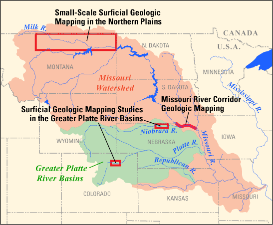
Project Study Areas
- Surficial Geologic Mapping Studies in the Greater Platte River Basins
- South Platte River Corridor, Eastern Colorado
- Niobrara National Scenic River, Nebraska
- Eolian Sediments in the Greater Platte River Basins, Great Plains
- Missouri River Corridor Geologic Mapping
- Small-Scale Surficial Geologic Mapping in the Northern Plains
Primary objectives of the project are to conduct surficial geologic mapping studies in the central and northern Great Plains in support of ecosystem and climate change research. Major goals are to obtain a better understanding of (1) past climate information recorded in the geologic record, and (2) geomorphic or climatic thresholds that may have triggered major changes in the ecosystems in the past. This information will be vital to regional land-use decision makers and managers trying to anticipate effects of future climate change and make informed choices among competing land uses.
The project directly supports several themes of the USGS Science Strategy:
- Climate and Land Use Change, Ecosystems, and Environmental Health: by studying past interactions between climate, earth surface processes, and ecosystems for evaluating:
- Future interactions as climate changes
- Ecosystem sustainability
- Wildlife and human health
- Water: by generating new information for managing water resources.
- Natural Hazards: by identifying past flood and wildfire events recorded in the geologic record
- Minerals: by assessing mineral and aggregate resources.
Project Study Areas
- Surficial Geologic Mapping Studies in the Greater Platte River Basins
- South Platte River Corridor, Eastern Colorado
- Niobrara National Scenic River, Nebraska
- Eolian Sediments in the Greater Platte River Basins, Great Plains
- Missouri River Corridor Geologic Mapping
- Small-Scale Surficial Geologic Mapping in the Northern Plains