
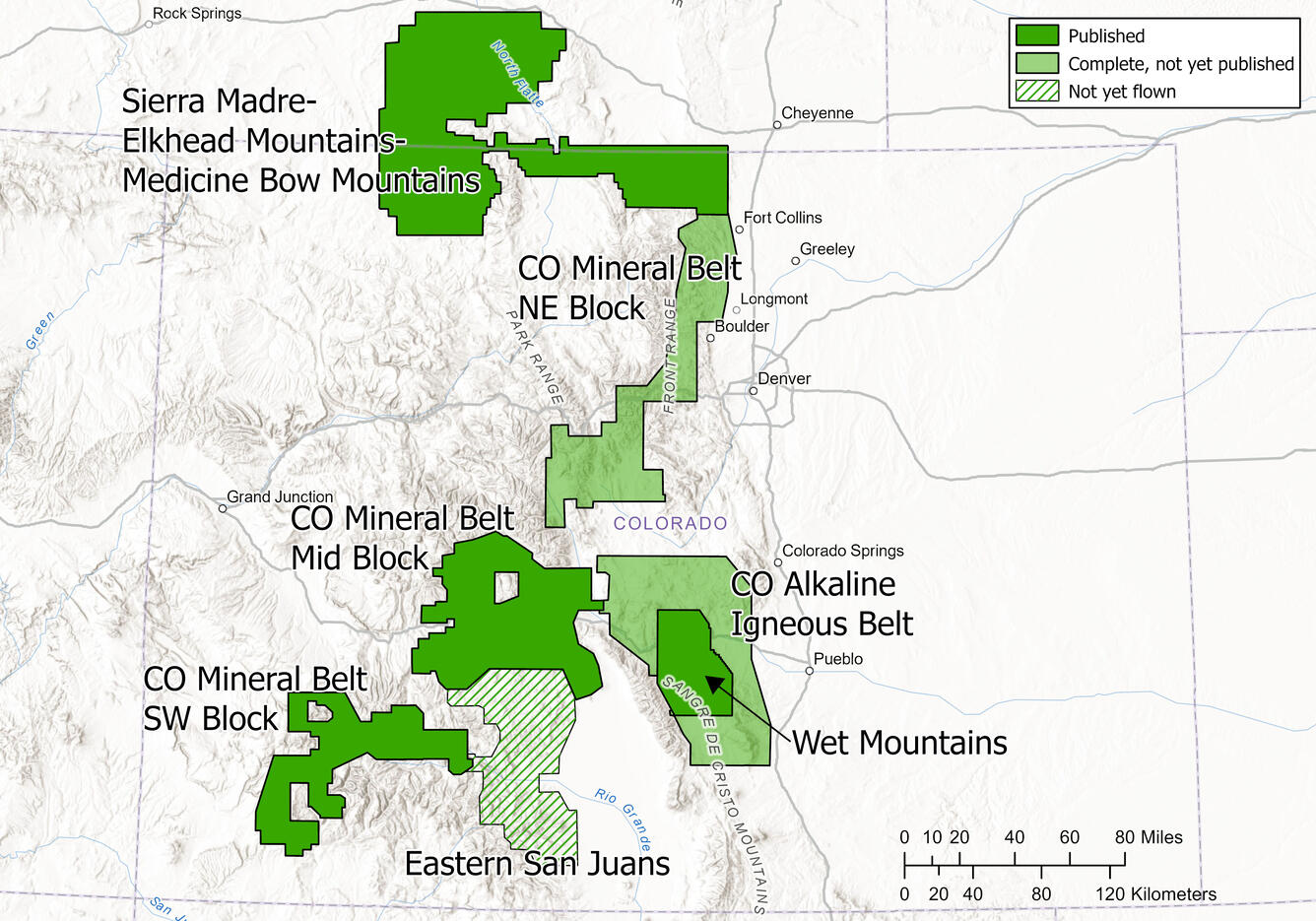
Geophysical and Geological Characterization of Mineral Deposit Localization in the Colorado Mineral Belt and Surrounding Lithosphere: Geophysical Data Analyses and Interpretations
Many of the questions about the origin of the Colorado Mineral Belt (CMB) extend underground. What path did ore-bearing fluids take to their final locations? How did they interact with preexisting structures like faults and fractures? Geophysical methods that allow us to "see" beneath the surface are powerful tools for answering these questions. We plan to use existing seismic data as well as the world-class magnetic and radiometric data from the Earth MRI project to delve beneath the surface in the CMB. Acquisition of new geophysical data, potentially including seismic, gravity, and magnetotelluric data, in targeted areas will help illuminate key magmatic features and geologic structures vital to understanding the processes that formed the Belt.
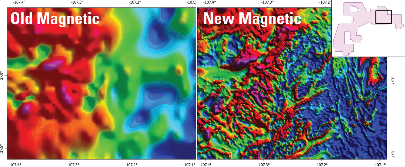
The detailed magnetic and radiometric dataset collected through Earth MRI provide an unprecedented level of detail on the surface and subsurface geology of the CMB. Magnetic surveys measure subtle changes in the Earth’s magnetic field. The magnetic field changes based on the amount of magnetic minerals present in different rocks, and how close those rocks are to the surface. Radiometric surveys measure changes in naturally occurring, background radiation that changes depending on the chemistry of the rocks at the surface. Together, the data from these surveys can yield insights on where rocks are and what they are made of, both at the surface and underground, in places that are commonly very difficult to access.
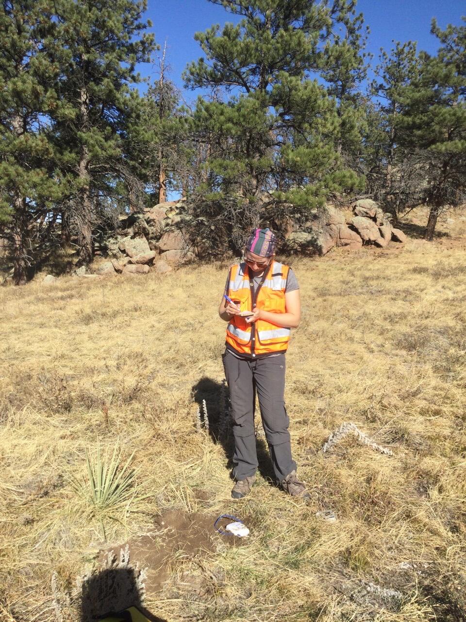
By burying seismometers in the ground and letting them “listen” to the vibrations of the Earth from earthquakes and even distant ocean waves for weeks, months, or even years, we can gain valuable insight on the rocks beneath our feet. Seismic methods can tell us about where we can find faults and fractures underground, and how they change as we go deeper in the Earth. They can also tell us what kinds of rocks are below the surface, and even sometimes how they have been affected by tectonic forces in the present or in the past. In the Colorado Mineral Belt, we are using seismology to understand how existing faults, fractures, and tectonic stress influenced the path and final locations of fluids associated with the formation of mineral deposits.
This project is a task of the Geophysical and Geological Characterization of Mineral Deposit Localization in the Colorado Mineral Belt and Surrounding Lithosphere project.

Geophysical and Geological Characterization of Mineral Deposit Localization in the Colorado Mineral Belt and Surrounding Lithosphere
Many of the questions about the origin of the Colorado Mineral Belt (CMB) extend underground. What path did ore-bearing fluids take to their final locations? How did they interact with preexisting structures like faults and fractures? Geophysical methods that allow us to "see" beneath the surface are powerful tools for answering these questions. We plan to use existing seismic data as well as the world-class magnetic and radiometric data from the Earth MRI project to delve beneath the surface in the CMB. Acquisition of new geophysical data, potentially including seismic, gravity, and magnetotelluric data, in targeted areas will help illuminate key magmatic features and geologic structures vital to understanding the processes that formed the Belt.
The detailed magnetic and radiometric dataset collected through Earth MRI provide an unprecedented level of detail on the surface and subsurface geology of the CMB. Magnetic surveys measure subtle changes in the Earth’s magnetic field. The magnetic field changes based on the amount of magnetic minerals present in different rocks, and how close those rocks are to the surface. Radiometric surveys measure changes in naturally occurring, background radiation that changes depending on the chemistry of the rocks at the surface. Together, the data from these surveys can yield insights on where rocks are and what they are made of, both at the surface and underground, in places that are commonly very difficult to access.
By burying seismometers in the ground and letting them “listen” to the vibrations of the Earth from earthquakes and even distant ocean waves for weeks, months, or even years, we can gain valuable insight on the rocks beneath our feet. Seismic methods can tell us about where we can find faults and fractures underground, and how they change as we go deeper in the Earth. They can also tell us what kinds of rocks are below the surface, and even sometimes how they have been affected by tectonic forces in the present or in the past. In the Colorado Mineral Belt, we are using seismology to understand how existing faults, fractures, and tectonic stress influenced the path and final locations of fluids associated with the formation of mineral deposits.
This project is a task of the Geophysical and Geological Characterization of Mineral Deposit Localization in the Colorado Mineral Belt and Surrounding Lithosphere project.