
Geologic Framework
Geologic Framework
Filter Total Items: 3

Characterizing the Water Resources of the Big Lost River Valley
In cooperation with the Idaho Department of Water Resources, we are working to improve the scientific understanding of the Big Lost River basin's water resources. This improved understanding will support effective resource management.
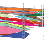
INLPO Geological Framework
A robust geological framework of the eastern Snake River Plain (ESRP) is essential for understanding the hydraulic and geologic properties of the ESRP aquifer, a vital source of drinking and irrigation water in southeastern Idaho. The development of an ESRP geologic framework model at the Idaho National Laboratory Project Office (INLPO) is informed by multiple datasets, including paleomagnetic...

Wood River Valley Hydrogeologic Framework
To make scientifically based water-resource decisions, elected officials, water managers, and the general public need additional information about the Wood River Valley aquifer system. A crucial part of this information is an improved understanding of the extent, thickness, and hydraulic properties of the aquifer—a hydrogeologic framework.