Geophysical Logging
Geophysical Logging
Filter Total Items: 3
Characterizing the Water Resources of the Big Lost River Valley
In cooperation with the Idaho Department of Water Resources, we are working to improve the scientific understanding of the Big Lost River basin's water resources. This improved understanding will support effective resource management.
INLPO Monitoring Networks
The INLPO Monitoring Networks are essential for understanding the dynamics of groundwater and surface water, facilitating effective management of water resources within the eastern Snake River Plain aquifer system. These networks consist of multiple components designed to monitor various aspects, such as water levels and quality, providing vital data for environmental assessments and informed...
INLPO Outreach
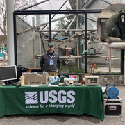
The USGS Idaho National Laboratory Project Office is committed to engaging the public through a variety of outreach initiatives across multiple locations. We provide enriching educational materials and content tailored for diverse audiences, including K-12 students, college classes, public forums, Water Festivals, Earth Day events, and citizen advisory board meetings. Our goal is to foster a...


