
Natural Hazards
Natural Hazards
Powell Center working groups rarely are just one USGS Mission Area and are sorted into these areas by the groups themselves. Projects may be relevant to additional areas.
Filter Total Items: 22
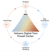
A digital twin to accelerate volcano science and unify geodetic and seismic observations
Emerging computational and data assimilation approaches and increasing data volumes imply an opportunity to greatly accelerate both fundamental volcano science and hazard assessment and forecasting.
Operationalizing the use of millennial-scale geologic constraints for testing and improving modern seismic hazard models
This Powell Center working group will improve the National Seismic Hazard Model by developing and operationalizing the first comprehensive set of geologic data on past earthquake shaking intensity.

A Global Synthesis of Flood Impacts: Understanding the Country-level Vulnerability and Causes
The escalating flood impacts on natural resources, built infrastructure, and human society have become a pressing global concern in the 21st century.

Improving airborne disaster response coordination and communication with real-time open environmental data
Air pollution exposure in the United States is worsening due to changes in the environment and extreme natural events, such as wildfires and volcanic eruptions.

Beyond waves and shifting sand: considering ecosystem processes in forecasts of coastal landscape change
Sea-level rise and storms cause major changes on coastal landscapes, including shifts in elevation, ecosystem type (for example, dunes and tidal wetlands), soils, and plant communities. Because these changes can have impacts on human communities, the local economy, and ecosystems, understanding how, when, and why these changes occur can be important for informing policy and natural...

Fiber Optic Seismology for Earthquake Hazards Research, Monitoring and Early Warning
A revolution is underway in seismology that transforms fiber-optic cables into arrays of thousands of seismic sensors. Compared to the traditional monitoring networks using inertial seismometers, the fiber-optic approach can increase the spatial data density by orders of magnitude and enable data processing methodologies that require a high-fidelity wavefield. The Working Group aims to...

Renewable Resilience: City-Scale Geothermal Energy Everywhere
Despite the proven efficacy of geothermal energy as a city-scale heating and cooling resource, the relative newness of most city-scale applications using diverse technologies has resulted in limited widespread adoption. We aim to develop authoritative information suitable for city-managers and other decision-makers. Geothermal resources are ubiquitous and diverse, with technologies...

Synthesizing patterns and drivers of changes in lake zooplankton community dynamics worldwide
Despite the critical services freshwater systems provide, freshwater communities have been vastly under-studied compared to terrestrial and marine biomes. In fact, systematic compilations of freshwater zooplankton are surprisingly rare despite the critical roles zooplankton play in regulating and supporting ecosystem services, serving as key indicator species, and consequently...

Towards an Integrated Understanding of Terrestrial Evapotranspiration
Terrestrial evapotranspiration (ET), the second-largest component of the terrestrial water cycle, links water, energy, and carbon cycles and influences the productivity and health of our ecosystems. Despite the importance of ET, the dynamics of ET across a spectrum of spatiotemporal scale and their controls are uncertain. During an international ET workshop held in November 2021 by...
Using a network of networks for high-frequency multi-depth soil moisture observations to infer spatial and temporal drivers of subsurface preferential flow
Subsurface preferential flow (PF = water bypassing the soil matrix) provides rapid flowpaths for water and any substances transported with it, thereby profoundly impacting the recharge of aquifers, the spreading of contaminants, the health of the soil, and the functioning of ecosystems. It involves a complexity of processes that are poorly understood to the degree that current science...
A National Topographic Change Mapping and Monitoring System
The three-dimensional (3D) form of the Earth’s surface results from both abiotic and biotic forces. Major abiotic forces, such as tectonic uplift, erosion, and climate, exert strong influence over land surface morphology. Biotic forces, including, significantly, humans, also shape the landscape, but often at different temporal and spatial scales and magnitudes than geologic forces...

Developing and Implementing an International Macroseismic Scale (IMS) for Earthquake Engineering, Earthquake Science, and Rapid Damage Assessment
The USGS “Did You Feel It” (DYFI) is an extremely popular way for members of the public to contribute to earthquake science and earthquake response. DYFI has been in operation for nearly two decades (1999-2019) in the U.S., and for nearly 15 years globally. During that period the amount of data collected is astounding: Over 5 million individual DYFI intensity reports—spanning all...