
Enhanced Characterization of the MAP Groundwater System
The current characterization of the MAP groundwater system relies on information gained through various methods at individual well locations. To complete a full picture of the system, the information between these points are assumed to continue over large areas. As a result, a detailed characterization of the MAP groundwater system suitable to evaluate water sustainability at the scales now required has not been produced. Because of the lack of detail, basic questions on aquifer characterization remain – for example, how thick are the clays that impede precipitation from recharging the aquifer? How well connected is the MAP groundwater system to deeper groundwater systems the area? And what areas in or near streams allow groundwater to move in and out of the system? Each aspect can have large effects on groundwater flow, particularly at the sub-county scale. High-resolution airborne geophysical surveys combined with drilling and logging of boreholes allow correlation of geophysical measurements to sands and clays within the aquifer, which translate into aquifer properties.
Hydrogeophysical surveys have become an integral part of understanding hydrogeological frameworks used in groundwater models. Regional models cover a large area where water well data is, at best, scattered and irregular. Since budgets are finite, priorities must be assigned to select optimal areas for geophysical surveys. The main objective of geophysical surveying is assumed to estimate values and spatial variation in hydrologic parameters (i.e. hydraulic conductivity) as well as map lower permeability layers that influence the spatial distribution of recharge flux.
The specific objectives of this program task over the course of five years will be to:
- Compile available data from state agencies to design an airborne geophysical survey to map critical groundwater areas in Mississippi and Arkansas
- Conduct airborne, surface, and borehole geophysical surveys to:
- Evaluate the geometry of the MAP groundwater system
- Map the 2 and 3-dimensional distribution of subsurface geologic properties controlling the flow and storage of groundwater
- Map the potential for interaction between the stream and groundwater systems at selected stream locations in Mississippi and Arkansas
- Develop a 3-dimensional framework for the MAP groundwater system
Continuous Resistivity Profiling
Continuous resistivity profiling is used to map the electrical properties of near-surface materials. Based on the resulting electrical properties the geological materials can be determined. Fine-grained materials, such as clay and silt, easily conduct electricity while coarser-grained materials, like sand, are resistant to electrical flow. Since the geologic materials have a direct impact on groundwater flow, knowing the distribution of these materials is important to understanding regional groundwater systems.
Waterborne
Waterborne resistivity surveys were conducted along 180 km (111 mi) of three rivers (Tallahatchie, Quiver, and Sunflower Rivers) in the Yazoo Basin of Mississippi during June 2016. Surveys were conducted a direct-current resistivity system that tows a 70 m-long floating, multi-electrode cable behind a slow-moving motorboat proceeding upstream. Electrodes transmit a low current into the bed materials of the stream and receive a signal back which allows the user to map the geology of the streambed. By understanding the geology of the streambed, the connectivity between surface streams and underlying groundwater systems can be better understood. This work will be used to scale streambed groundwater flow rates for incorporation into a regional groundwater flow model, which may be used to guide policy decisions.

Land-based
Land-based resistivity surveys were conducted in August 2016, using an capacitively-coupled resistivity system which allows the user to map the near-surface geology by pulling a series of seven electrodes behind a vehicle along dirt and gravel roads. Low currents transmitted into the earth, via these electrodes, are used to map the near-surface geology of the surveyed area. Variations in the geological materials of the Mississippi Alluvial Plain can significantly influence the rate at which an aquifer is recharged. These geological materials have a direct result on groundwater levels and flow rates. This work will help to understand the influence that the near-surface geology has on the groundwater flow of the region.

Airborne
The airborne electromagnetic (AEM) methods are geophysical measurements that measure variations in the electrical resistivity of subsurface materials by sensing the flow of electrical currents in different types of geologic deposits (Smith and others, 2007). An AEM survey has several advantages, including the ability to map large areas with a higher density of data coverage and the ability to cover areas with rugged terrain, and is a noninvasive method of data collection using a helicopter or fixed-wing airplane (Ball and others, 2011). Historically, AEM surveys have been used to map mineral deposits; however, it has been increasingly used for geologic and hydrologic studies (Smith and others, 2007). The AEM method has proven effective for mapping groundwater supplies because of the distinctive resistivity signatures of water-bearing geologic materials (Smith and others, 2007); thus, AEM methods can be used to map the thickness and extent of aquifers, and provide important input data for a groundwater-flow model.
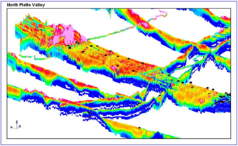
The current characterization of the MAP groundwater system relies on information gained through various methods at individual well locations. To complete a full picture of the system, the information between these points are assumed to continue over large areas. As a result, a detailed characterization of the MAP groundwater system suitable to evaluate water sustainability at the scales now required has not been produced. Because of the lack of detail, basic questions on aquifer characterization remain – for example, how thick are the clays that impede precipitation from recharging the aquifer? How well connected is the MAP groundwater system to deeper groundwater systems the area? And what areas in or near streams allow groundwater to move in and out of the system? Each aspect can have large effects on groundwater flow, particularly at the sub-county scale. High-resolution airborne geophysical surveys combined with drilling and logging of boreholes allow correlation of geophysical measurements to sands and clays within the aquifer, which translate into aquifer properties.
Hydrogeophysical surveys have become an integral part of understanding hydrogeological frameworks used in groundwater models. Regional models cover a large area where water well data is, at best, scattered and irregular. Since budgets are finite, priorities must be assigned to select optimal areas for geophysical surveys. The main objective of geophysical surveying is assumed to estimate values and spatial variation in hydrologic parameters (i.e. hydraulic conductivity) as well as map lower permeability layers that influence the spatial distribution of recharge flux.
The specific objectives of this program task over the course of five years will be to:
- Compile available data from state agencies to design an airborne geophysical survey to map critical groundwater areas in Mississippi and Arkansas
- Conduct airborne, surface, and borehole geophysical surveys to:
- Evaluate the geometry of the MAP groundwater system
- Map the 2 and 3-dimensional distribution of subsurface geologic properties controlling the flow and storage of groundwater
- Map the potential for interaction between the stream and groundwater systems at selected stream locations in Mississippi and Arkansas
- Develop a 3-dimensional framework for the MAP groundwater system
Continuous Resistivity Profiling
Continuous resistivity profiling is used to map the electrical properties of near-surface materials. Based on the resulting electrical properties the geological materials can be determined. Fine-grained materials, such as clay and silt, easily conduct electricity while coarser-grained materials, like sand, are resistant to electrical flow. Since the geologic materials have a direct impact on groundwater flow, knowing the distribution of these materials is important to understanding regional groundwater systems.
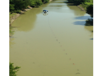
Waterborne
Waterborne resistivity surveys were conducted along 180 km (111 mi) of three rivers (Tallahatchie, Quiver, and Sunflower Rivers) in the Yazoo Basin of Mississippi during June 2016. Surveys were conducted a direct-current resistivity system that tows a 70 m-long floating, multi-electrode cable behind a slow-moving motorboat proceeding upstream. Electrodes transmit a low current into the bed materials of the stream and receive a signal back which allows the user to map the geology of the streambed. By understanding the geology of the streambed, the connectivity between surface streams and underlying groundwater systems can be better understood. This work will be used to scale streambed groundwater flow rates for incorporation into a regional groundwater flow model, which may be used to guide policy decisions.
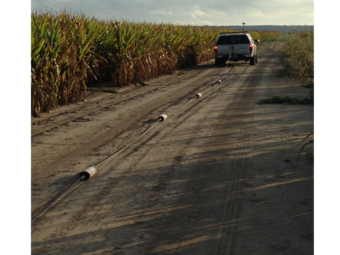
Land-based
Land-based resistivity surveys were conducted in August 2016, using an capacitively-coupled resistivity system which allows the user to map the near-surface geology by pulling a series of seven electrodes behind a vehicle along dirt and gravel roads. Low currents transmitted into the earth, via these electrodes, are used to map the near-surface geology of the surveyed area. Variations in the geological materials of the Mississippi Alluvial Plain can significantly influence the rate at which an aquifer is recharged. These geological materials have a direct result on groundwater levels and flow rates. This work will help to understand the influence that the near-surface geology has on the groundwater flow of the region.
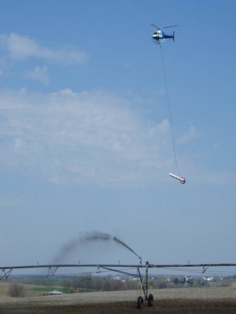
Airborne
The airborne electromagnetic (AEM) methods are geophysical measurements that measure variations in the electrical resistivity of subsurface materials by sensing the flow of electrical currents in different types of geologic deposits (Smith and others, 2007). An AEM survey has several advantages, including the ability to map large areas with a higher density of data coverage and the ability to cover areas with rugged terrain, and is a noninvasive method of data collection using a helicopter or fixed-wing airplane (Ball and others, 2011). Historically, AEM surveys have been used to map mineral deposits; however, it has been increasingly used for geologic and hydrologic studies (Smith and others, 2007). The AEM method has proven effective for mapping groundwater supplies because of the distinctive resistivity signatures of water-bearing geologic materials (Smith and others, 2007); thus, AEM methods can be used to map the thickness and extent of aquifers, and provide important input data for a groundwater-flow model.