
The USGS Nevada Water Science Center (NVWSC), in partnership with the Bureau of Land Management (BLM), is conducting hydrologic and hydraulic modeling studies to support stream restoration.
BACKGROUND
Many Nevada streams have been altered by:
- Irrigation ditches that divert water away from natural channels
- Levees that disconnect streams from floodplains
- Dams that store water and sediment
These changes have disrupted natural habitats for native, threatened, and endangered aquatic and riparian species. To restore these ecosystems, the BLM needs detailed information about:
- How water flows under normal and flood conditions
- Water depth and velocity within stream channels
- How these conditions might change under restoration scenarios.
To provide this information, the USGS uses two types of modeling:
- Hydrologic modeling uses data and computer simulations to understand how water moves across land and through streams: how much water flows, where it goes, and when.
- Hydraulic modeling simulates how water moves within stream channels and floodplains: its depth, speed, and interaction with the channel.
APPROACH
USGS NVWSC studies follow a process built around seven main tasks:
Step 1: Collect elevation data
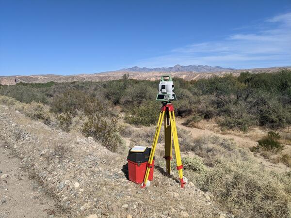
Aerial lidar (light detection and ranging) provides high-resolution topography
Lidar cannot penetrate water or dense vegetation, so additional surveys using total station, global navigation satellite system, or terrestrial laser scanners fill the gaps.
These data are combined to create a complete 3D map of the study area.
Step 2: Estimate streamflow
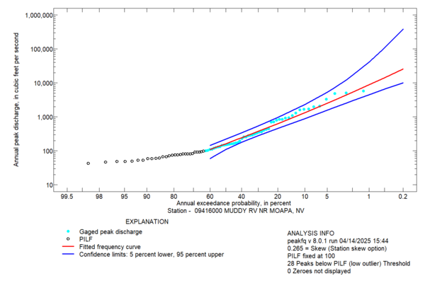
Base flow is estimated using streamflow measurements or streamgage records.
Flood conditions are simulated using flood-frequency analysis or precipitation-runoff models.
Steps 3 - 6: Build and Run Models
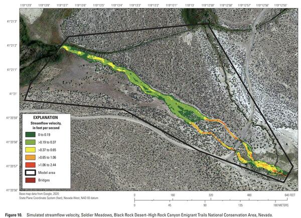
3: Build hydraulic models
Elevation and estimated streamflow data are combined to create 1D or 2D models.
These models simulate water movement and depth.
4: Simulate current conditions
Run models for current conditions.
Calibrate using streamgage data and high-water marks.
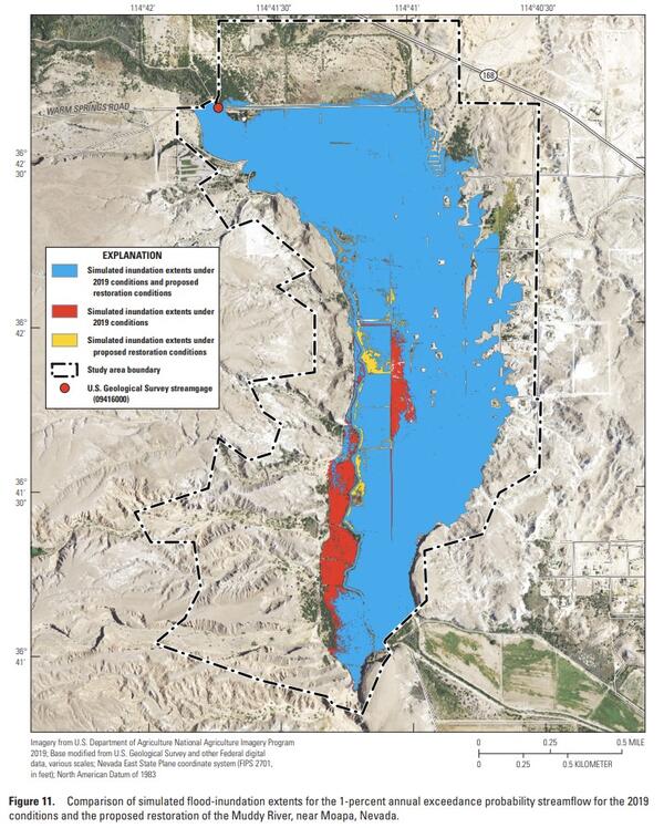
5: Test restoration scenarios
Change model inputs to reflect restoration plans, such as:
- Less irrigation withdrawal
- Physical changes to the stream channel or floodplain
- Changes in riparian vegetation.
6: Simulate restoration scenarios.
Run models again to see how restoration changes water flow.
Step 7: Create maps
Show how water depth, speed, and flood areas change with restoration.
STUDY LOCATIONS
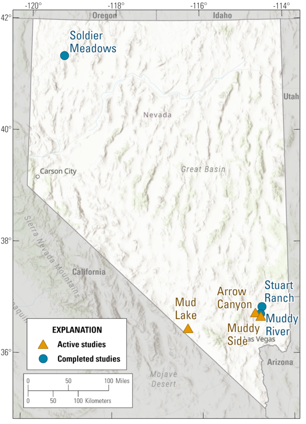
ACTIVE STUDIES
- Arrow Canyon
- Mud Lake
- Muddy Side
COMPLETED STUDIES
Muddy River
Soldier Meadows
Stuart Ranch
The USGS Nevada Water Science Center (NVWSC), in partnership with the Bureau of Land Management (BLM), is conducting hydrologic and hydraulic modeling studies to support stream restoration.
BACKGROUND
Many Nevada streams have been altered by:
- Irrigation ditches that divert water away from natural channels
- Levees that disconnect streams from floodplains
- Dams that store water and sediment
These changes have disrupted natural habitats for native, threatened, and endangered aquatic and riparian species. To restore these ecosystems, the BLM needs detailed information about:
- How water flows under normal and flood conditions
- Water depth and velocity within stream channels
- How these conditions might change under restoration scenarios.
To provide this information, the USGS uses two types of modeling:
- Hydrologic modeling uses data and computer simulations to understand how water moves across land and through streams: how much water flows, where it goes, and when.
- Hydraulic modeling simulates how water moves within stream channels and floodplains: its depth, speed, and interaction with the channel.
APPROACH
USGS NVWSC studies follow a process built around seven main tasks:
Step 1: Collect elevation data
Aerial lidar (light detection and ranging) provides high-resolution topography
Lidar cannot penetrate water or dense vegetation, so additional surveys using total station, global navigation satellite system, or terrestrial laser scanners fill the gaps.
These data are combined to create a complete 3D map of the study area.
Step 2: Estimate streamflow
Base flow is estimated using streamflow measurements or streamgage records.
Flood conditions are simulated using flood-frequency analysis or precipitation-runoff models.
Steps 3 - 6: Build and Run Models
3: Build hydraulic models
Elevation and estimated streamflow data are combined to create 1D or 2D models.
These models simulate water movement and depth.
4: Simulate current conditions
Run models for current conditions.
Calibrate using streamgage data and high-water marks.
5: Test restoration scenarios
Change model inputs to reflect restoration plans, such as:
- Less irrigation withdrawal
- Physical changes to the stream channel or floodplain
- Changes in riparian vegetation.
6: Simulate restoration scenarios.
Run models again to see how restoration changes water flow.
Step 7: Create maps
Show how water depth, speed, and flood areas change with restoration.
STUDY LOCATIONS
ACTIVE STUDIES
- Arrow Canyon
- Mud Lake
- Muddy Side
COMPLETED STUDIES
Muddy River
Soldier Meadows
Stuart Ranch