An official website of the United States government
Here's how you know
Official websites use .gov
A .gov website belongs to an official government organization in the United States.
Secure .gov websites use HTTPS
A lock () or https:// means you’ve safely connected to the .gov website. Share sensitive information only on official, secure websites.
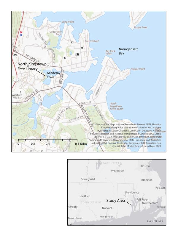
In 2020, the USGS began a partnership with the U.S. Environmental Protection Agency (EPA) Region 1 Southeast New England Program for Coastal Watershed Restoration (SNEP) and EPA Office of Research and Development (ORD), Atlantic Coastal Sciences Division, Narragansett, RI in support of water-quality and ecological monitoring being conducted by ORD in the coastal waters around Wickford, RI. The USGS is conducting a study to characterize groundwater and surface-water quality to address the need for a better understanding of nutrient inputs to these coastal waters. The study focuses on local-scale hydrologic and water-quality monitoring adjacent to Academy Cove and assessing watershed-scale nitrogen loads to Academy Cove and Wickford Cove.
Wickford, Rhode Island is in a densely developed area on the western shore of Narragansett Bay where sewers are being installed to reduce nutrient loading (nitrogen is the constituent of greatest concern) to streams and coastal embayments (Fig. 1). EPA ORD has been monitoring water quality and sampling sediment and algae at 10 locations in the saltwater embayments around Wickford since 2019; however, there is a lack of nitrogen-loading information from the watershed to complement the embayment monitoring.
Coastal areas receive nitrogen inputs from both groundwater and surface-water sources in the watershed bordering the coastline. Nitrogen concentrations and loads to the Wickford embayments likely vary both spatially and temporally in response to seasonality, storm events, and longer-term factors such as changes in land-use and wastewater-disposal practices. Differences in travel times will also affect groundwater nitrogen loading from bordering watersheds.
Sewer installation has been ongoing since 2018 in Wickford, and, consequently, groundwater nitrogen loading to surface waters from local sources is expected to begin to decline over time. However, data are not available to determine current nitrogen-loading conditions or evaluate the magnitude and rate-of-change of loading in response to sewering. To better understand nutrient inputs to the coastal waters around Wickford, USGS is conducting a study to characterize groundwater and surface-water quality and nitrogen loads. Local-scale hydrologic and water-quality monitoring was conducted from 2021 to 2025 on the western side of Academy Cove at North Kingston Free Library (Fig. 1). Groundwater nitrogen concentrations and loads before and after the connection of the library septic system to the municipal sewer system will be evaluated to better understand the effects of the library's sewer conversion on water quality. An existing USGS groundwater model is being used to assess watershed-scale nitrogen loads to Academy Cove and Wickford Cove in response to sewering.
Figure 2. Tide gage installed in Academy Cove in 2021.
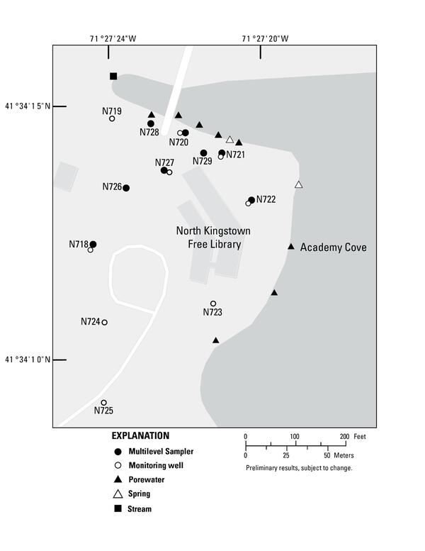
Several phases of field work were conducted to characterize subsurface geologic conditions, groundwater flow directions, and groundwater and surface-water quality at the North Kingstown Free Library. A tide gage that measured water levels at 5-minute intervals was also installed in Academy Cove from 2021 to 2023 (Fig. 2). Site-characterization work included installation of temporary subsurface sample points near the shoreline of Academy Cove, installation of monitoring wells and multilevel samplers (MLS), core collection, groundwater-level monitoring to determine local groundwater flow directions, and collection of groundwater and surface-water quality samples (Fig. 3). Water-quality samples were collected from a stream that discharges to the northwest side of Academy Cove, spring sites along the western shore of Academy Cove, nearby ponds, the temporary subsurface sample points, and the groundwater monitoring network.
The groundwater monitoring network at the site consists of eight MLS and nine monitoring wells (Fig. 4). MLS contain multiple (typically 15) closely-spaced sampling ports to provide detailed vertical profiles of groundwater quality. Vertical profiles of groundwater quality (nitrate, ammonium, dissolved oxygen, pH, and specific conductance) from an MLS sampled in September 2021 are shown in Figure 5. Water-quality results from the groundwater monitoring network will provide information on the effects of the cessation of wastewater discharge from the library septic system on groundwater quality.
Figure 4. Site map of the study area showing the location of monitoring wells, multilevel samplers, temporary subsurface sample points near the shoreline of Academy Cove, and locations where surface-water quality samples were collected, Wickford, Rhode Island.
Work related to the watershed-scale nitrogen loading analysis has included: using the existing USGS groundwater model of the Hunt-Annaquatucket-Pettaquamscutt River Basins to simulate the recharge contributing areas and groundwater travel times to Academy Cove and Wickford Cove, using publicly available geospatial data of on-site wastewater treatment systems to map the distributions of septic systems, and using published values of water use and wastewater nitrogen concentrations to estimate nitrogen loading from septic systems. These datasets will be used to evaluate the magnitude and rate-of-change of nitrogen loading to Academy Cove and Wickford Cove in response to sewering. Results from this study will be used to support the models of estuarine response to nutrient loading being developed by EPA ORD.
Figure 5. Vertical profiles of groundwater quality upgradient from Academy Cove, September 2021. Water-quality data are published in the U.S. Geological Survey National Water Information System (NWIS) database (https://waterdata.usgs.gov/)
Below are multimedia items associated with this project.
USGS Interpretive Sign on Nutrient Pollution Entering Rhode Island Coastal Waters
An interpretive sign put together by USGS about research on nutrient pollution entering into Academy Cove in North Kingston, Rhode Island, and affecting coastal waters.
An interpretive sign put together by USGS about research on nutrient pollution entering into Academy Cove in North Kingston, Rhode Island, and affecting coastal waters.
The USGS is conducting a study to characterize groundwater and surface water-quality to address the need for a better understanding of nutrient inputs to the coastal waters. The initial focus of the study is on local-scale hydrologic monitoring adjacent to Academy Cove.
The USGS is conducting a study to characterize groundwater and surface water-quality to address the need for a better understanding of nutrient inputs to the coastal waters. The initial focus of the study is on local-scale hydrologic monitoring adjacent to Academy Cove.
Three river basins in central Rhode Island-the Hunt River, the Annaquatucket River, and the Pettaquamscutt River-contain 15 production wells clustered in 4 pumping centers from which drinking water is withdrawn. These high-capacity production wells, operated by three water suppliers, are screened in coarse-grained deposits of glacial origin. The risk of contaminating water withdrawn by...
In 2020, the USGS began a partnership with the U.S. Environmental Protection Agency (EPA) Region 1 Southeast New England Program for Coastal Watershed Restoration (SNEP) and EPA Office of Research and Development (ORD), Atlantic Coastal Sciences Division, Narragansett, RI in support of water-quality and ecological monitoring being conducted by ORD in the coastal waters around Wickford, RI. The USGS is conducting a study to characterize groundwater and surface-water quality to address the need for a better understanding of nutrient inputs to these coastal waters. The study focuses on local-scale hydrologic and water-quality monitoring adjacent to Academy Cove and assessing watershed-scale nitrogen loads to Academy Cove and Wickford Cove.
Wickford, Rhode Island is in a densely developed area on the western shore of Narragansett Bay where sewers are being installed to reduce nutrient loading (nitrogen is the constituent of greatest concern) to streams and coastal embayments (Fig. 1). EPA ORD has been monitoring water quality and sampling sediment and algae at 10 locations in the saltwater embayments around Wickford since 2019; however, there is a lack of nitrogen-loading information from the watershed to complement the embayment monitoring.
Coastal areas receive nitrogen inputs from both groundwater and surface-water sources in the watershed bordering the coastline. Nitrogen concentrations and loads to the Wickford embayments likely vary both spatially and temporally in response to seasonality, storm events, and longer-term factors such as changes in land-use and wastewater-disposal practices. Differences in travel times will also affect groundwater nitrogen loading from bordering watersheds.
Sewer installation has been ongoing since 2018 in Wickford, and, consequently, groundwater nitrogen loading to surface waters from local sources is expected to begin to decline over time. However, data are not available to determine current nitrogen-loading conditions or evaluate the magnitude and rate-of-change of loading in response to sewering. To better understand nutrient inputs to the coastal waters around Wickford, USGS is conducting a study to characterize groundwater and surface-water quality and nitrogen loads. Local-scale hydrologic and water-quality monitoring was conducted from 2021 to 2025 on the western side of Academy Cove at North Kingston Free Library (Fig. 1). Groundwater nitrogen concentrations and loads before and after the connection of the library septic system to the municipal sewer system will be evaluated to better understand the effects of the library's sewer conversion on water quality. An existing USGS groundwater model is being used to assess watershed-scale nitrogen loads to Academy Cove and Wickford Cove in response to sewering.
Figure 2. Tide gage installed in Academy Cove in 2021.
Several phases of field work were conducted to characterize subsurface geologic conditions, groundwater flow directions, and groundwater and surface-water quality at the North Kingstown Free Library. A tide gage that measured water levels at 5-minute intervals was also installed in Academy Cove from 2021 to 2023 (Fig. 2). Site-characterization work included installation of temporary subsurface sample points near the shoreline of Academy Cove, installation of monitoring wells and multilevel samplers (MLS), core collection, groundwater-level monitoring to determine local groundwater flow directions, and collection of groundwater and surface-water quality samples (Fig. 3). Water-quality samples were collected from a stream that discharges to the northwest side of Academy Cove, spring sites along the western shore of Academy Cove, nearby ponds, the temporary subsurface sample points, and the groundwater monitoring network.
The groundwater monitoring network at the site consists of eight MLS and nine monitoring wells (Fig. 4). MLS contain multiple (typically 15) closely-spaced sampling ports to provide detailed vertical profiles of groundwater quality. Vertical profiles of groundwater quality (nitrate, ammonium, dissolved oxygen, pH, and specific conductance) from an MLS sampled in September 2021 are shown in Figure 5. Water-quality results from the groundwater monitoring network will provide information on the effects of the cessation of wastewater discharge from the library septic system on groundwater quality.
Figure 4. Site map of the study area showing the location of monitoring wells, multilevel samplers, temporary subsurface sample points near the shoreline of Academy Cove, and locations where surface-water quality samples were collected, Wickford, Rhode Island.
Work related to the watershed-scale nitrogen loading analysis has included: using the existing USGS groundwater model of the Hunt-Annaquatucket-Pettaquamscutt River Basins to simulate the recharge contributing areas and groundwater travel times to Academy Cove and Wickford Cove, using publicly available geospatial data of on-site wastewater treatment systems to map the distributions of septic systems, and using published values of water use and wastewater nitrogen concentrations to estimate nitrogen loading from septic systems. These datasets will be used to evaluate the magnitude and rate-of-change of nitrogen loading to Academy Cove and Wickford Cove in response to sewering. Results from this study will be used to support the models of estuarine response to nutrient loading being developed by EPA ORD.
Figure 5. Vertical profiles of groundwater quality upgradient from Academy Cove, September 2021. Water-quality data are published in the U.S. Geological Survey National Water Information System (NWIS) database (https://waterdata.usgs.gov/)
Below are multimedia items associated with this project.
USGS Interpretive Sign on Nutrient Pollution Entering Rhode Island Coastal Waters
An interpretive sign put together by USGS about research on nutrient pollution entering into Academy Cove in North Kingston, Rhode Island, and affecting coastal waters.
An interpretive sign put together by USGS about research on nutrient pollution entering into Academy Cove in North Kingston, Rhode Island, and affecting coastal waters.
The USGS is conducting a study to characterize groundwater and surface water-quality to address the need for a better understanding of nutrient inputs to the coastal waters. The initial focus of the study is on local-scale hydrologic monitoring adjacent to Academy Cove.
The USGS is conducting a study to characterize groundwater and surface water-quality to address the need for a better understanding of nutrient inputs to the coastal waters. The initial focus of the study is on local-scale hydrologic monitoring adjacent to Academy Cove.
Three river basins in central Rhode Island-the Hunt River, the Annaquatucket River, and the Pettaquamscutt River-contain 15 production wells clustered in 4 pumping centers from which drinking water is withdrawn. These high-capacity production wells, operated by three water suppliers, are screened in coarse-grained deposits of glacial origin. The risk of contaminating water withdrawn by...