Stormdrain During a Heavy Rainfall Event in Massachusetts
Stormdrain During a Heavy Rainfall Event in MassachusettsA stormdrain receiving water input during a high-precipitation storm in Massachusetts.

Official websites use .gov
A .gov website belongs to an official government organization in the United States.
Secure .gov websites use HTTPS
A lock () or https:// means you’ve safely connected to the .gov website. Share sensitive information only on official, secure websites.
Alana Burton Spaetzel is a Supervisory Hydrologist in the New England Water Science Center.


A stormdrain receiving water input during a high-precipitation storm in Massachusetts.
A stormdrain receiving water input during a high-precipitation storm in Massachusetts.

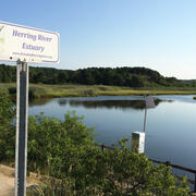
This is a downstream view of the Herring River from the Chequessett Neck Road dike. The site was visited on November 6, 2017 to collect water-quality samples. An automated sampler inside the gage house was used to collect samples over an approximately 24-hour period and combine them into two bottles.
This is a downstream view of the Herring River from the Chequessett Neck Road dike. The site was visited on November 6, 2017 to collect water-quality samples. An automated sampler inside the gage house was used to collect samples over an approximately 24-hour period and combine them into two bottles.
A stormdrain receiving water input during a high-precipitation storm in Massachusetts.
A stormdrain receiving water input during a high-precipitation storm in Massachusetts.
This is a downstream view of the Herring River from the Chequessett Neck Road dike. The site was visited on November 6, 2017 to collect water-quality samples. An automated sampler inside the gage house was used to collect samples over an approximately 24-hour period and combine them into two bottles.
This is a downstream view of the Herring River from the Chequessett Neck Road dike. The site was visited on November 6, 2017 to collect water-quality samples. An automated sampler inside the gage house was used to collect samples over an approximately 24-hour period and combine them into two bottles.