
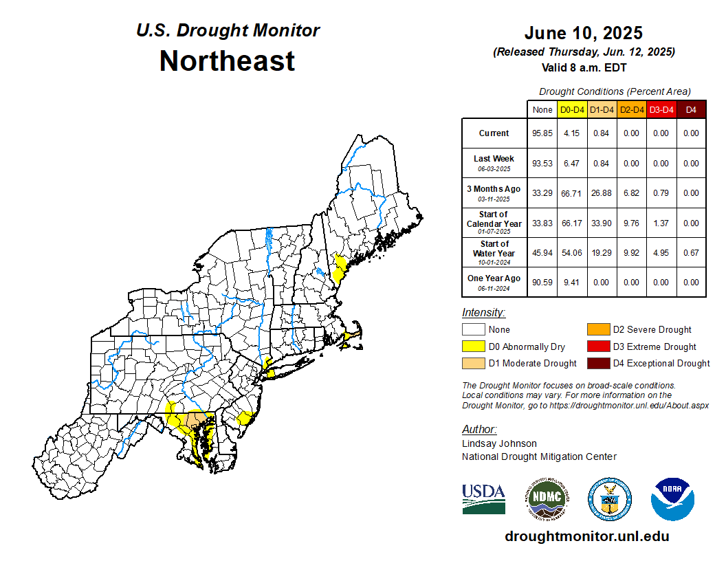
Droughts are one of the most expensive and damaging hydrologic hazards in the United States. They are generally slow in developing, frequently occur over a long period of time, and can affect large areas and populations.
The U.S. Geological Survey New England Water Science Center's long-term continuous monitoring network of surface water and groundwater stations provide data to define drought severity. The New England Water Science Center continuously monitors the status of New England's principal rivers, reservoirs, and aquifers to compare current hydrologic conditions with normal and extreme recorded values.
Current Drought Conditions in the Northeastern United States
USGS Drought Information
Streamflow
National Water Dashboard for New England
Groundwater
National Water Dashboard for New England
Drought Forecasting: Streamflow and Groundwater Probabilities
- Northeast Region Drought Streamflow Probabilities
- Drought Forecasting for Groundwater in Northeastern U.S.
Other Drought Related Maps and Information
- National Integrated Drought Information System (NIDIS) – National Current Conditions
- Northeast Drought Early Warning System (DEWS) Dashboard
- NIDIS Drought Data and Maps - Northeast
- National Drought Mitigation Center
- Northeast DEWS Drought Status Update
New England State Drought Information
Historical Droughts in New England
Droughts are one of the most expensive and damaging hydrologic hazards in the United States. They are generally slow in developing, frequently occur over a long period of time, and can affect large areas and populations.
The U.S. Geological Survey New England Water Science Center's long-term continuous monitoring network of surface water and groundwater stations provide data to define drought severity. The New England Water Science Center continuously monitors the status of New England's principal rivers, reservoirs, and aquifers to compare current hydrologic conditions with normal and extreme recorded values.
Current Drought Conditions in the Northeastern United States
USGS Drought Information
Streamflow
National Water Dashboard for New England
Groundwater
National Water Dashboard for New England
Drought Forecasting: Streamflow and Groundwater Probabilities
- Northeast Region Drought Streamflow Probabilities
- Drought Forecasting for Groundwater in Northeastern U.S.
Other Drought Related Maps and Information
- National Integrated Drought Information System (NIDIS) – National Current Conditions
- Northeast Drought Early Warning System (DEWS) Dashboard
- NIDIS Drought Data and Maps - Northeast
- National Drought Mitigation Center
- Northeast DEWS Drought Status Update