
Science
The New Jersey Water Science Center's mission is to collect, and disseminate reliable scientific information on issues affecting rivers, lakes, estuaries, groundwater, and water resources across the state of New Jersey and its neighbors. These data provide the scientific knowledge that engineers, planners, and managers can use to make informed water-resources decisions.
New Jersey Current Water Conditions

Real-time New Jersey Streamflow, Groundwater, and Water-quality conditions available through the Natioan Water Data Dashboard interactive map application.
Research and Investigations

New Jersey Water Science Center conducts research and investigations to provide the scientific knowledge that engineers, planners and managers can used to make informed water-resources decisions.
NJ WSC Quick Links
Explore some of our more popular science and tools
Surface Water
Groundwater
Water Quality and Emerging Contaminants
Natural Hazards
Coastal Science
Water Availability and Use
Atmospheric
Hydrologic Modeling
Advanced Capabilities and Data Visualization
Science Topics
Education
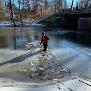
How does Ice on Rivers and Streams Affect USGS Streamflow Data How does Ice on Rivers and Streams Affect USGS Streamflow Data

Major aquifers in New Jersey Major aquifers in New Jersey
