
Hydrogeologic Mapping and Three-Dimensional Geologic Modeling of Glacial Deposits in a Multicounty Area of Southeastern Michigan, Northeastern Indiana, and Northwestern Ohio
Diagram of classes of lithologies
Created by the OKI Water Science Center Scientists
Groundwater resources in southern Michigan, northeastern Indiana, and northwestern Ohio, have been a recurring subject of interest related to sources of public, irrigation, and other water supplies and the potential of glacial deposits to supply water to adjacent parts of Ohio. The glacial deposits that are part of the aquifer system informally known as the “Michindoh aquifer” are a principal source of water to local communities, agriculture, and industry in the region. Long-term understanding of the water budget of the region is of critical interest to residents, agriculture, commerce, and future development as the aquifer is the only source of drinking water to this area. Improved mapping of the extent of aquifer deposits is of critical need to assess water resources.
Recent USGS multi-state compilations of state-based water-well and bedrock drilling records can provide data to map the extent of aquifer deposits and identify information needs where those deposits have not been characterized by water-well drilling. These data can be used to create a digital geologic model of the distribution and hydrogeologic characteristics of aquifers in this region that would become the framework for a regional groundwater flow model. The digital geological model also can be used to estimate the hydrologic properties of the aquifers of the region and identify locations where additional resource monitoring is needed.
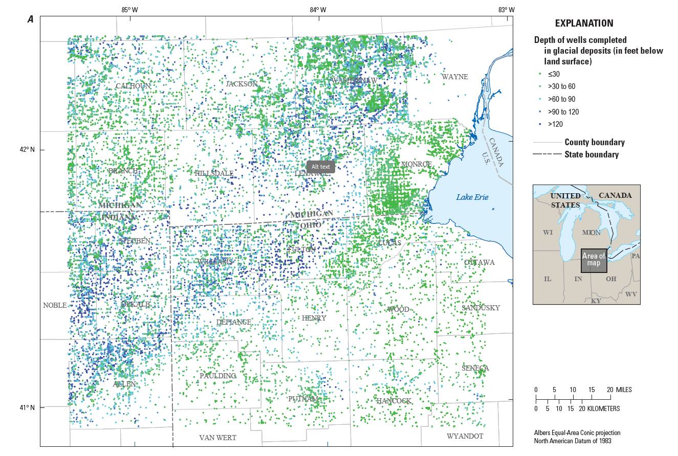
Description: Maps showing the distribution of wells completed in glacial deposits used to create maps of hydrogeologic information and a three-dimensional volumetric model for the glacial deposits.
Study Objectives
In cooperation with the Ohio Environmental Protection Agency, the objectives of the project are to:
1. Prepare two-dimensional maps of hydrogeologic properties and a three-dimensional digital geologic framework model to describe the glacial aquifer system in parts of northwestern Ohio, northeastern Indiana, and southern Michigan using water-well drillers’ logs.
The mapping products will be used to define:
- Thickness of glacial deposits over bedrock
- Approximate elevation of the bedrock surface
- Texture-based estimates of hydraulic conductivity (K) and transmissivity (T) of the aquifer represented in available well logs.
2. Establish a long-term monitoring network that helps fill in areas that lack sufficient monitoring and establish new groundwater sites in the region. The data will be made publicly available through the USGS NWISWeb interface. Additionally, existing groundwater wells throughout the study area will be identified and two synoptic measurements of instantaneous groundwater levels will be performed and used to create potentiometric surface maps during the growing (irrigation) and non-growing seasons to understand the distribution of groundwater in the aquifer system.
| State | Counties |
| Ohio | Williams. Fulton, Defiance (parts of Paulding and Henry |
| Michigan | Branch Hillsdale, Lenawee |

Relevance and Benefits
The proposed effort provides the region’s citizens, officials, and natural-resource planners with information needed to understand and manage the groundwater resources. The maps and digital geologic framework created from this effort provide data that can directly inform assessments of groundwater availability, in addition to having future applications to studies of groundwater flow and transport. The expanded monitoring network delivers publicly accessible timely hydrologic data, analyses, and tools seamlessly to support water-resource decisions.
Results
Analysis of the mapping products indicate that aquifer materials are primarily concentrated in the western parts of the study area near the Indiana-Ohio border. Coarse-grained sediments are also present as surficial deposits in the north of the study area where intermixing glacial advances created complex distributions of unconsolidated deposits. Two-dimensional maps of hydrogeologic properties support the volumetric model, showing thicknesses of coarse-grained deposits that reach up to 250 feet in the western sections of the study area and progressively thin to near absence in the east. Visualization of the aquifer materials with a volumetric model generally shows a highly discontinuous distribution of coarse- and fine-grained materials, with no clearly defined boundaries to delineate the extent of the aquifer. Comparisons of cross sections derived from the volumetric model with existing published maps support previous near-surface hydrogeologic interpretations while filling gaps where data are sparse, particularly in deeper parts of the aquifer.
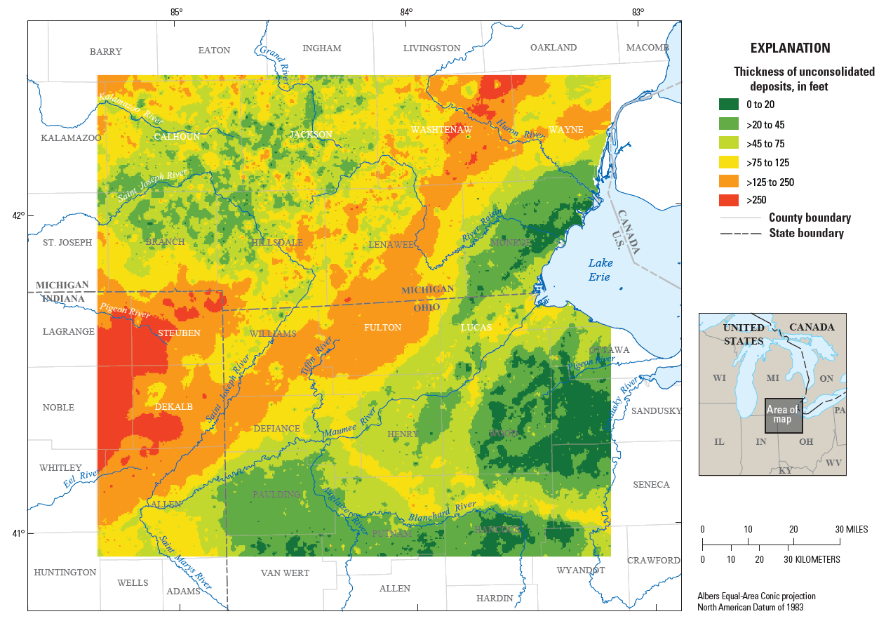
Description: Map showing thickness of coarse-grained deposits.
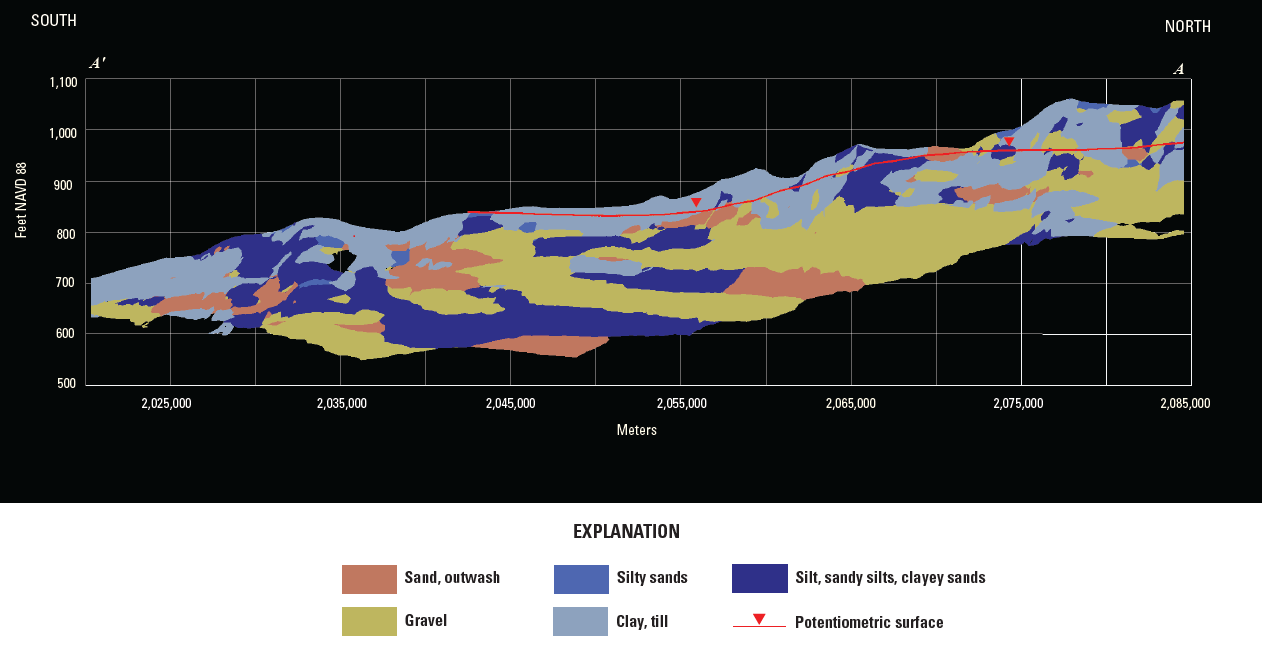
Description: Volumetric model cross section through Allen, DeKalb, and Steuben Counties in Indiana.

Description: Existing USGS groundwater-level networks were enhanced through 1) the addition of newly drilled deep wells that nearly reach bedrock, and 2) conversion of discrete wells to continuous, real-time wells (see “Data” tab)
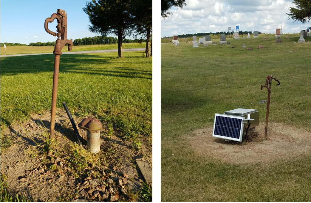
USGS Groundwater Monitoring Well WM-111 in Williams County, Ohio before and after conversion to a Real-Time Monitoring well. Data available at https://nwis.waterdata.usgs.gov/nwis/uv?site_no=413812084444601
The report and accompanying data release is available at: https://doi.org/10.3133/sir20255008.
Riddle, A.D., 2025, Hydrogeologic framework of the glacial deposits in a multicounty area of southeastern Michigan, northeastern Indiana, and northwestern Ohio: U.S. Geological Survey data release, https://doi.org/10.5066/P13BO3GJ.
Williams County, Ohio
- OH015 412819084323800 WM-1A OH
- OH015 412930084320900 WM-3 OH
- OH015 413108084415300 WM-12 OH
- USGS 413812084444601 WM-111 OH - Monitoring at location initiated for this study
- USGS 413952084261201 WM-113 OH - Monitoring at location initiated for this study
- USGS 413812084444602 WM-112 OH - Monitoring at location initiated for this study
- USGS 413952084261202 WM-114 OH - Monitoring at location initiated for this study
- USGS 412803084480401 WM-115 OH - Monitoring at location initiated for this study
Fulton County, Ohio
Defiance County, Ohio
- USGS 412306084240000 DE-30 OH - Monitoring at location initiated for this study
- USGS 412304084440601 DE-31 OH - Monitoring at location initiated for this study
Henry County, Ohio
Steuben County, Indiana
- USGS 414325084552401 STEUBEN 10 (SB 10)
- USGS 413754084540601 STEUBEN 11 (SB 11)
- USGS 413754084540602 STEUBEN 12 (SB 12)
Dekalb County, Indiana
Allen County, Indiana
- USGS 410428085171701 ALLEN 9 (AL9) CH8
- USGS 411043085035201 ALLEN 10 (AL 10)
- USGS 411042085035201 ALLEN 11 (AL 11)
Branch County, Michigan
Riddle, A.D., Arihood, L.D., Naylor, S., and Lampe, D.C., 2025, Hydrogeologic mapping and three-dimensional geologic modeling of glacial deposits in a multicounty area of southeastern Michigan, northeastern Indiana, and northwestern Ohio: U.S. Geological Survey Scientific Investigations Report 2025–5008, 47 p., https://doi.org/10.3133/sir20255008.
Bayless, E.R., Arihood, L.D., and Sperl, B.J., 2017, Maps and grids of hydrogeologic information created from standardized water-well drillers’ records of the glaciated United States: U.S. Geological Survey data release, https://doi.org/10.5066/F7BR8QCZ.
Arihood, L.D., 2018, MODFLOW-2000 model used to illustrate the differences in flow paths and travel times when three-dimensional kriging is used to estimate the hydraulic conductivity distribution as compared to manual determinations of hydraulic conductivity distribution: U.S. Geological Survey data release, https://doi.org/10.5066/F7QN65RW.
Arihood, L.D., 2009, Processing, analysis, and general evaluation of well-driller records for estimating hydrogeologic parameters of the glacial sediments in a ground-water flow model of the Lake Michigan Basin: U.S. Geological Survey Scientific Investigations Report 2008-5184, 26 p. https://pubs.usgs.gov/sir/2008/5184/
Arihood, L.D., D.C. Lampe, E.R. Bayless, and S.E. Brown, 2019, Comparison of Groundwater-Model Construction Methods, Representations of Glacial Geology, Model Designs, and Groundwater-Model Flow Simulations within Elkhart County, Indiana: U.S. Geological Survey Scientific Investigations Report 2019-5088
Bayless, E.R., Arihood, L.D., Reeves, H.W., Sperl, B.J.S., Qi, S.L., Stipe, V.E., and Bunch, A.R., 2017, Maps and grids of hydrogeologic information created from standardized water-well drillers’ records of the glaciated United States: U.S. Geological Survey Scientific Investigations Report 2015–5105, 34 p., https://doi.org/10.3133/sir20155105.
Feinstein, D.T., Hunt, R.J., and Reeves, H.W., 2010, Regional groundwater-flow model of the Lake Michigan Basin in support of Great Lakes Basin water availability and use studies: U.S. Geological Survey Scientific Investigations Report 2010–5109, 379 p. https://pubs.usgs.gov/sir/2010/5109/
Lampe, D.C., 2009, Hydrogeologic framework of bedrock units and initial salinity distribution for a simulation of groundwater flow for the Lake Michigan Basin: U.S. Geological Survey Scientific Investigations Report 2009–5060, 49 p. https://pubs.usgs.gov/sir/2009/5060/
U.S. Environmental Protection Agency, 2013, EPA in Ohio: Michindoh Aquifer: accessed September 6, 2018 at URL https://www.epa.gov/oh/michindoh-aquifer
Groundwater resources in southern Michigan, northeastern Indiana, and northwestern Ohio, have been a recurring subject of interest related to sources of public, irrigation, and other water supplies and the potential of glacial deposits to supply water to adjacent parts of Ohio. The glacial deposits that are part of the aquifer system informally known as the “Michindoh aquifer” are a principal source of water to local communities, agriculture, and industry in the region. Long-term understanding of the water budget of the region is of critical interest to residents, agriculture, commerce, and future development as the aquifer is the only source of drinking water to this area. Improved mapping of the extent of aquifer deposits is of critical need to assess water resources.
Recent USGS multi-state compilations of state-based water-well and bedrock drilling records can provide data to map the extent of aquifer deposits and identify information needs where those deposits have not been characterized by water-well drilling. These data can be used to create a digital geologic model of the distribution and hydrogeologic characteristics of aquifers in this region that would become the framework for a regional groundwater flow model. The digital geological model also can be used to estimate the hydrologic properties of the aquifers of the region and identify locations where additional resource monitoring is needed.
Description: Maps showing the distribution of wells completed in glacial deposits used to create maps of hydrogeologic information and a three-dimensional volumetric model for the glacial deposits.
Study Objectives
In cooperation with the Ohio Environmental Protection Agency, the objectives of the project are to:
1. Prepare two-dimensional maps of hydrogeologic properties and a three-dimensional digital geologic framework model to describe the glacial aquifer system in parts of northwestern Ohio, northeastern Indiana, and southern Michigan using water-well drillers’ logs.
The mapping products will be used to define:
- Thickness of glacial deposits over bedrock
- Approximate elevation of the bedrock surface
- Texture-based estimates of hydraulic conductivity (K) and transmissivity (T) of the aquifer represented in available well logs.
2. Establish a long-term monitoring network that helps fill in areas that lack sufficient monitoring and establish new groundwater sites in the region. The data will be made publicly available through the USGS NWISWeb interface. Additionally, existing groundwater wells throughout the study area will be identified and two synoptic measurements of instantaneous groundwater levels will be performed and used to create potentiometric surface maps during the growing (irrigation) and non-growing seasons to understand the distribution of groundwater in the aquifer system.
| State | Counties |
| Ohio | Williams. Fulton, Defiance (parts of Paulding and Henry |
| Michigan | Branch Hillsdale, Lenawee |
Relevance and Benefits
The proposed effort provides the region’s citizens, officials, and natural-resource planners with information needed to understand and manage the groundwater resources. The maps and digital geologic framework created from this effort provide data that can directly inform assessments of groundwater availability, in addition to having future applications to studies of groundwater flow and transport. The expanded monitoring network delivers publicly accessible timely hydrologic data, analyses, and tools seamlessly to support water-resource decisions.
Results
Analysis of the mapping products indicate that aquifer materials are primarily concentrated in the western parts of the study area near the Indiana-Ohio border. Coarse-grained sediments are also present as surficial deposits in the north of the study area where intermixing glacial advances created complex distributions of unconsolidated deposits. Two-dimensional maps of hydrogeologic properties support the volumetric model, showing thicknesses of coarse-grained deposits that reach up to 250 feet in the western sections of the study area and progressively thin to near absence in the east. Visualization of the aquifer materials with a volumetric model generally shows a highly discontinuous distribution of coarse- and fine-grained materials, with no clearly defined boundaries to delineate the extent of the aquifer. Comparisons of cross sections derived from the volumetric model with existing published maps support previous near-surface hydrogeologic interpretations while filling gaps where data are sparse, particularly in deeper parts of the aquifer.
Description: Map showing thickness of coarse-grained deposits.
Description: Volumetric model cross section through Allen, DeKalb, and Steuben Counties in Indiana.
Description: Existing USGS groundwater-level networks were enhanced through 1) the addition of newly drilled deep wells that nearly reach bedrock, and 2) conversion of discrete wells to continuous, real-time wells (see “Data” tab)
USGS Groundwater Monitoring Well WM-111 in Williams County, Ohio before and after conversion to a Real-Time Monitoring well. Data available at https://nwis.waterdata.usgs.gov/nwis/uv?site_no=413812084444601
The report and accompanying data release is available at: https://doi.org/10.3133/sir20255008.
Riddle, A.D., 2025, Hydrogeologic framework of the glacial deposits in a multicounty area of southeastern Michigan, northeastern Indiana, and northwestern Ohio: U.S. Geological Survey data release, https://doi.org/10.5066/P13BO3GJ.
Williams County, Ohio
- OH015 412819084323800 WM-1A OH
- OH015 412930084320900 WM-3 OH
- OH015 413108084415300 WM-12 OH
- USGS 413812084444601 WM-111 OH - Monitoring at location initiated for this study
- USGS 413952084261201 WM-113 OH - Monitoring at location initiated for this study
- USGS 413812084444602 WM-112 OH - Monitoring at location initiated for this study
- USGS 413952084261202 WM-114 OH - Monitoring at location initiated for this study
- USGS 412803084480401 WM-115 OH - Monitoring at location initiated for this study
Fulton County, Ohio
Defiance County, Ohio
- USGS 412306084240000 DE-30 OH - Monitoring at location initiated for this study
- USGS 412304084440601 DE-31 OH - Monitoring at location initiated for this study
Henry County, Ohio
Steuben County, Indiana
- USGS 414325084552401 STEUBEN 10 (SB 10)
- USGS 413754084540601 STEUBEN 11 (SB 11)
- USGS 413754084540602 STEUBEN 12 (SB 12)
Dekalb County, Indiana
Allen County, Indiana
- USGS 410428085171701 ALLEN 9 (AL9) CH8
- USGS 411043085035201 ALLEN 10 (AL 10)
- USGS 411042085035201 ALLEN 11 (AL 11)
Branch County, Michigan
Riddle, A.D., Arihood, L.D., Naylor, S., and Lampe, D.C., 2025, Hydrogeologic mapping and three-dimensional geologic modeling of glacial deposits in a multicounty area of southeastern Michigan, northeastern Indiana, and northwestern Ohio: U.S. Geological Survey Scientific Investigations Report 2025–5008, 47 p., https://doi.org/10.3133/sir20255008.
Bayless, E.R., Arihood, L.D., and Sperl, B.J., 2017, Maps and grids of hydrogeologic information created from standardized water-well drillers’ records of the glaciated United States: U.S. Geological Survey data release, https://doi.org/10.5066/F7BR8QCZ.
Arihood, L.D., 2018, MODFLOW-2000 model used to illustrate the differences in flow paths and travel times when three-dimensional kriging is used to estimate the hydraulic conductivity distribution as compared to manual determinations of hydraulic conductivity distribution: U.S. Geological Survey data release, https://doi.org/10.5066/F7QN65RW.
Arihood, L.D., 2009, Processing, analysis, and general evaluation of well-driller records for estimating hydrogeologic parameters of the glacial sediments in a ground-water flow model of the Lake Michigan Basin: U.S. Geological Survey Scientific Investigations Report 2008-5184, 26 p. https://pubs.usgs.gov/sir/2008/5184/
Arihood, L.D., D.C. Lampe, E.R. Bayless, and S.E. Brown, 2019, Comparison of Groundwater-Model Construction Methods, Representations of Glacial Geology, Model Designs, and Groundwater-Model Flow Simulations within Elkhart County, Indiana: U.S. Geological Survey Scientific Investigations Report 2019-5088
Bayless, E.R., Arihood, L.D., Reeves, H.W., Sperl, B.J.S., Qi, S.L., Stipe, V.E., and Bunch, A.R., 2017, Maps and grids of hydrogeologic information created from standardized water-well drillers’ records of the glaciated United States: U.S. Geological Survey Scientific Investigations Report 2015–5105, 34 p., https://doi.org/10.3133/sir20155105.
Feinstein, D.T., Hunt, R.J., and Reeves, H.W., 2010, Regional groundwater-flow model of the Lake Michigan Basin in support of Great Lakes Basin water availability and use studies: U.S. Geological Survey Scientific Investigations Report 2010–5109, 379 p. https://pubs.usgs.gov/sir/2010/5109/
Lampe, D.C., 2009, Hydrogeologic framework of bedrock units and initial salinity distribution for a simulation of groundwater flow for the Lake Michigan Basin: U.S. Geological Survey Scientific Investigations Report 2009–5060, 49 p. https://pubs.usgs.gov/sir/2009/5060/
U.S. Environmental Protection Agency, 2013, EPA in Ohio: Michindoh Aquifer: accessed September 6, 2018 at URL https://www.epa.gov/oh/michindoh-aquifer