
Muddy, or turbid water, caused by suspended-sediment released during Fall Creek Reservoir draw down. Reservoir was drawn down to purge sediment and trapped fish from behind dam in December 2012.
Geomorphic Response to Fall Creek Lake Drawdowns
Active
By Oregon Water Science Center
August 8, 2018
The USGS has been documenting the geomorphic response to the annual Fall Creek Lake drawdown since 2011.
Overview
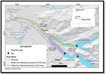
Lake levels at the U.S. Army Corps of Engineers’ Fall Creek Dam are drawn down to facilitate downstream passage of juvenile spring Chinook salmon through the 55-meter high structure. Since 2011, annual fall-winter drawdowns have improved fish passage, but have also exposed reservoir deposits to erosive streamflows, triggering increased transport of predominantly fine (<2 millimeter) sediment to downstream gravel-bed reaches of Fall Creek and the Middle Fork Willamette River. Repeated releases of reservoir sediments have uncertain long-term consequences for downstream reaches where dam construction has reduced peak flows, coarse sediment transport, and habitat creation.
Media
Sources/Usage: Public Domain. View Media Details
Sediment erosion and deposition in the reservoir reach are being evaluated with survey data collected in 2016–17 from unmanned aerial systems (UAS) and manned fixed-wing aircraft. Geomorphic change in downstream reaches related to drawdown operations is quantitatively assessed using aerial photograph mapping spanning 1936–2016 and volumetric change analyses from repeat lidar topography acquired in 2008–12 and 2015. Local changes in deposition patterns are documented from 2015 to 2017 with field mapping, deposition measurements on clay-horizon markers, and grain-size analyses.
Study Objectives
Study objectives are to:
- document reach‐scale geomorphic responses to sediment released from Fall Creek Lake from 2011 to 2017
- evaluate how reservoir operations affect sediment erosion within the reservoir, downstream transport, and re-deposition of reservoir sediment
- place these responses within the broader context of geomorphic stability and historical changes to these river systems.
Science projects associated with this project.

Fall Creek Drawdown
Each autumn Fall Creek Lake is drawn down to allow endangered juvenile salmonids to pass freely through the dam. The drawdowns involve lowering the lake water level to the lake bed, creating a fluvial environment characterized by large amounts of sediment being transported through the dam and into Fall Creek and the Middle Fork Willamette River.
Multimedia items associated with this project.

Turbid Water in Fall Creek
Muddy, or turbid water, caused by suspended-sediment released during Fall Creek Reservoir draw down. Reservoir was drawn down to purge sediment and trapped fish from behind dam in December 2012.
The USGS has been documenting the geomorphic response to the annual Fall Creek Lake drawdown since 2011.
Overview
Lake levels at the U.S. Army Corps of Engineers’ Fall Creek Dam are drawn down to facilitate downstream passage of juvenile spring Chinook salmon through the 55-meter high structure. Since 2011, annual fall-winter drawdowns have improved fish passage, but have also exposed reservoir deposits to erosive streamflows, triggering increased transport of predominantly fine (<2 millimeter) sediment to downstream gravel-bed reaches of Fall Creek and the Middle Fork Willamette River. Repeated releases of reservoir sediments have uncertain long-term consequences for downstream reaches where dam construction has reduced peak flows, coarse sediment transport, and habitat creation.
Media
Sources/Usage: Public Domain. View Media Details
Sediment erosion and deposition in the reservoir reach are being evaluated with survey data collected in 2016–17 from unmanned aerial systems (UAS) and manned fixed-wing aircraft. Geomorphic change in downstream reaches related to drawdown operations is quantitatively assessed using aerial photograph mapping spanning 1936–2016 and volumetric change analyses from repeat lidar topography acquired in 2008–12 and 2015. Local changes in deposition patterns are documented from 2015 to 2017 with field mapping, deposition measurements on clay-horizon markers, and grain-size analyses.
Study Objectives
Study objectives are to:
- document reach‐scale geomorphic responses to sediment released from Fall Creek Lake from 2011 to 2017
- evaluate how reservoir operations affect sediment erosion within the reservoir, downstream transport, and re-deposition of reservoir sediment
- place these responses within the broader context of geomorphic stability and historical changes to these river systems.
Science projects associated with this project.
Fall Creek Drawdown
Each autumn Fall Creek Lake is drawn down to allow endangered juvenile salmonids to pass freely through the dam. The drawdowns involve lowering the lake water level to the lake bed, creating a fluvial environment characterized by large amounts of sediment being transported through the dam and into Fall Creek and the Middle Fork Willamette River.
Multimedia items associated with this project.
Turbid Water in Fall Creek
Muddy, or turbid water, caused by suspended-sediment released during Fall Creek Reservoir draw down. Reservoir was drawn down to purge sediment and trapped fish from behind dam in December 2012.
Muddy, or turbid water, caused by suspended-sediment released during Fall Creek Reservoir draw down. Reservoir was drawn down to purge sediment and trapped fish from behind dam in December 2012.