
Looking downstream at McKay Creek above its confluence with the Crooked River, Oregon. McKay Creek originates in the Ochoco National Forest and flows for 37 miles, passing through private agricultural lands before merging with the Crooked River northwest of Prineville in Crook County.
Identifying nitrate sources in the lower Crooked River
Active
By Oregon Water Science Center
January 31, 2025
The U.S. Geological Survey (USGS) and the Crooked River Watershed Council (CRWC) are working together to identify sources of nitrate entering Lake Billy Chinook from the Crooked River Basin to help resource managers improve water quality.
Overview
Lake Billy Chinook is a large reservoir in central Oregon that faces significant water-quality challenges due to seasonal blooms of algae and cyanobacteria, which have negative effects on aquatic life and recreational use. These blooms are largely driven by nitrate loading from the Crooked River, which contributes 86% of the annual nitrate influx to the reservoir (Eilers, 2021). Addressing nitrate loading from the Crooked River is crucial for improving water quality in both Lake Billy Chinook and the downstream Deschutes River. The CRWC has been studying how nitrate loading changes over time in different areas of the Crooked River Basin (Mount Hood Environmental and Crooked River Watershed Council, 2022). Their recent findings include:
- Year-round, nitrate loads are relatively small below the Prineville and Ochoco Reservoirs and increase downstream.
- Nitrate loads in the Crooked River and most of its tributaries are greatest in November and December.
- Nitrate load increases substantially as the Crooked River flows through the City of Prineville.
- Nitrate load increases substantially in the lower 20-mile stretch of the Crooked River, which is mainly fed by groundwater.
Building on these findings this study aims to identify where the nitrate in the river is coming from.
Media
Sources/Usage: Public Domain. View Media Details
Study Objectives
- Isotopic Analysis of Nitrate: Use stable isotopes of nitrogen and oxygen to identify nitrate sources and differentiate between natural and human contributions.
- Water Source Analysis: Use stable isotopes of water to trace the origins of groundwater contributing to nitrate loading, particularly along the lower 20 miles of the river.
How do isotopes help us identify nitrate sources?
Nitrate is made up of isotopes of nitrogen and oxygen. Isotopes are variations of a chemical element that have different masses. Despite having different masses, isotopes of the same element share nearly identical chemical properties and react similarly in the environment.
By comparing the abundance of oxygen and nitrogen isotopes in nitrate molecules found in water samples to known isotopic compositions from various nitrate sources (such as fertilizer, septic tank effluent, or naturally occurring in soils), scientists can identify the likely origins of the nitrate.
Why This Research Matters
Findings from this study are of considerable interest to fishery, power generation, agricultural, ranching, municipal, and recreational activities in the region. Because the Crooked River is the biggest source of nitrate loading to Lake Billy Chinook, reducing nitrate loading into the river is important to help limit harmful algal blooms in the reservoir and the Deschutes River downstream (Eilers, 2021). Poor water quality affects the endangered or threatened fish species that may migrate through Lake Billy Chinook, the recreational use of the reservoir, and downstream fisheries.
The study will help local communities understand where the nitrate in the Crooked River comes from and guide efforts to reduce it. The USGS was chosen for this study because of its impartial and reliable scientific expertise. The study will also help the USGS improve its understanding of groundwater flow and spring hydrology in the larger Deschutes River Basin, expand the use of isotopic tracers in research, and add valuable data to the USGS national database on water chemistry.
Citations:
Eilers, J., & Vache, K. (2021). Water Quality Study for the Pelton Round Butte and the Lower Deschutes River: Monitoring & Modeling.
Mount Hood Environmental and Crooked River Watershed Council. 2022. Lower Crooked River Water Quality Monitoring Project. Technical report prepared for the City of Prineville, Crook County, and Ochoco Irrigation District. Mount Hood Environmental, Boring, OR. 32 pp.
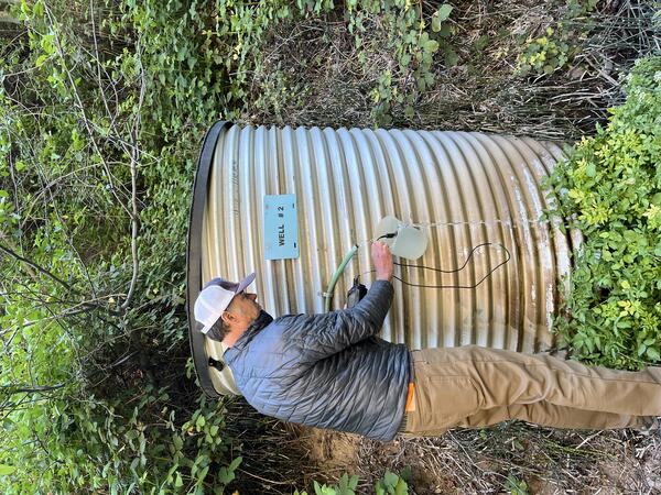
Photos taken during field work for this study.
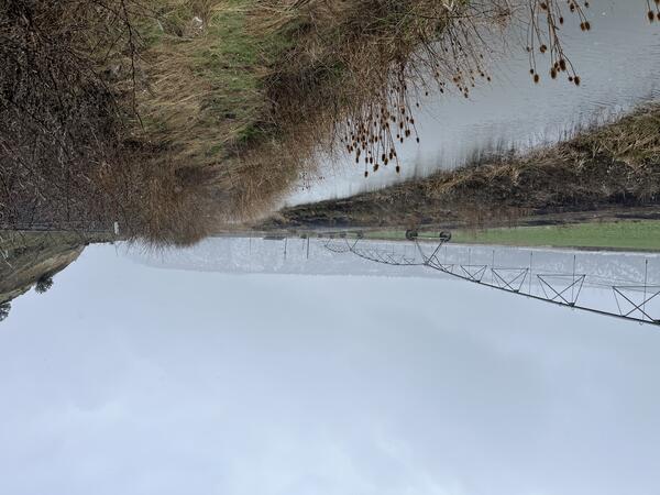
McKay Creek
Looking downstream at McKay Creek above its confluence with the Crooked River, Oregon. McKay Creek originates in the Ochoco National Forest and flows for 37 miles, passing through private agricultural lands before merging with the Crooked River northwest of Prineville in Crook County.
The U.S. Geological Survey (USGS) and the Crooked River Watershed Council (CRWC) are working together to identify sources of nitrate entering Lake Billy Chinook from the Crooked River Basin to help resource managers improve water quality.
Overview
Lake Billy Chinook is a large reservoir in central Oregon that faces significant water-quality challenges due to seasonal blooms of algae and cyanobacteria, which have negative effects on aquatic life and recreational use. These blooms are largely driven by nitrate loading from the Crooked River, which contributes 86% of the annual nitrate influx to the reservoir (Eilers, 2021). Addressing nitrate loading from the Crooked River is crucial for improving water quality in both Lake Billy Chinook and the downstream Deschutes River. The CRWC has been studying how nitrate loading changes over time in different areas of the Crooked River Basin (Mount Hood Environmental and Crooked River Watershed Council, 2022). Their recent findings include:
- Year-round, nitrate loads are relatively small below the Prineville and Ochoco Reservoirs and increase downstream.
- Nitrate loads in the Crooked River and most of its tributaries are greatest in November and December.
- Nitrate load increases substantially as the Crooked River flows through the City of Prineville.
- Nitrate load increases substantially in the lower 20-mile stretch of the Crooked River, which is mainly fed by groundwater.
Building on these findings this study aims to identify where the nitrate in the river is coming from.
Media
Sources/Usage: Public Domain. View Media Details
Study Objectives
- Isotopic Analysis of Nitrate: Use stable isotopes of nitrogen and oxygen to identify nitrate sources and differentiate between natural and human contributions.
- Water Source Analysis: Use stable isotopes of water to trace the origins of groundwater contributing to nitrate loading, particularly along the lower 20 miles of the river.
How do isotopes help us identify nitrate sources?
Nitrate is made up of isotopes of nitrogen and oxygen. Isotopes are variations of a chemical element that have different masses. Despite having different masses, isotopes of the same element share nearly identical chemical properties and react similarly in the environment.
By comparing the abundance of oxygen and nitrogen isotopes in nitrate molecules found in water samples to known isotopic compositions from various nitrate sources (such as fertilizer, septic tank effluent, or naturally occurring in soils), scientists can identify the likely origins of the nitrate.
Why This Research Matters
Findings from this study are of considerable interest to fishery, power generation, agricultural, ranching, municipal, and recreational activities in the region. Because the Crooked River is the biggest source of nitrate loading to Lake Billy Chinook, reducing nitrate loading into the river is important to help limit harmful algal blooms in the reservoir and the Deschutes River downstream (Eilers, 2021). Poor water quality affects the endangered or threatened fish species that may migrate through Lake Billy Chinook, the recreational use of the reservoir, and downstream fisheries.
The study will help local communities understand where the nitrate in the Crooked River comes from and guide efforts to reduce it. The USGS was chosen for this study because of its impartial and reliable scientific expertise. The study will also help the USGS improve its understanding of groundwater flow and spring hydrology in the larger Deschutes River Basin, expand the use of isotopic tracers in research, and add valuable data to the USGS national database on water chemistry.
Citations:
Eilers, J., & Vache, K. (2021). Water Quality Study for the Pelton Round Butte and the Lower Deschutes River: Monitoring & Modeling.
Mount Hood Environmental and Crooked River Watershed Council. 2022. Lower Crooked River Water Quality Monitoring Project. Technical report prepared for the City of Prineville, Crook County, and Ochoco Irrigation District. Mount Hood Environmental, Boring, OR. 32 pp.
Photos taken during field work for this study.
McKay Creek
Looking downstream at McKay Creek above its confluence with the Crooked River, Oregon. McKay Creek originates in the Ochoco National Forest and flows for 37 miles, passing through private agricultural lands before merging with the Crooked River northwest of Prineville in Crook County.
Looking downstream at McKay Creek above its confluence with the Crooked River, Oregon. McKay Creek originates in the Ochoco National Forest and flows for 37 miles, passing through private agricultural lands before merging with the Crooked River northwest of Prineville in Crook County.