
USGS Releases the Pennsylvania Groundwater Quality Monitoring Network Data Exploration Tool
New “Pennsylvania Groundwater Quality Monitoring Network Data Exploration Tool” displays monitoring results on an interactive map.
USGS, in cooperation with the Pennsylvania Department of Environmental Protection, samples 28 wells biannually to monitor ambient groundwater quality conditions throughout Pennsylvania.
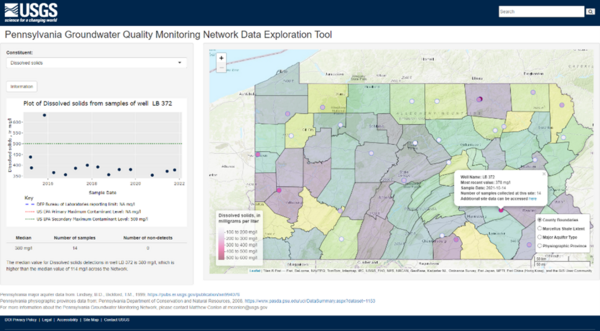
Users can interactively explore water quality results of the Pennsylvania Groundwater Quality Monitoring Network on a map. Selecting a well generates a plot that displays all measurements of the selected constituent over time at that well.
Additional information presented for the selected constituent includes the number of samples collected and the number of detections at the selected well, as well as the median value across the network.
Water quality data for this project has been published as a USGS Data Release titled Collection of Analytical Data for the Pennsylvania Groundwater Monitoring Network. This Data Release, and the Web Tool, will be updated annually with the most recent data.
Water quality constituents available:
- Water temperature
- Specific conductance
- Dissolved oxygen
- pH
- Nitrate
- Calcium
- Magnesium
- Sodium
- Potassium
- Chloride
- Sulfate
- Fluoride
- Silica
- Barium
- Iron
- Manganese
- Alkalinity
- Turbidity
- Dissolved solids
Related

Pennsylvania Groundwater Quality Monitoring Network
Related