
Floods
Floods
Filter Total Items: 18

Floods and the South Atlantic Water Science Center
Georgia, North Carolina and South Carolina flood related information.

Flood-inundation mapping in Tar River Basin, North Carolina
The U.S. Geological Survey (USGS) has created flood-inundation maps for selected streamgage sites in North Carolina. These maps depict the approximate area that would be inundated at selected water levels, ranging from approximately top-of-bank to the maximum observed water level. The inundated areas depicted on these maps are approximate, and accuracy of the maps is a function of the accuracy of...

Hurricane Monitoring Information for Georgia, North Carolina, and South Carolina
Hurricane Information for Georgia, North Carolina, and South Carolina.

The 1977 Toccoa Flood, Report of Failure of Kelly Barnes Dam Flood and Findings
The Kelly Barnes Dam, located above the Toccoa Falls Bible College near Toccoa, Georgia, failed in the early morning hours of November 6, 1977. Thirty-nine people died in the resulting flood, which inundated part of the campus including a trailer park. These Web pages make available two historical reports on the flood and an album of photos of the disaster.

South Atlantic Water Science Center Storm-Tide Monitoring
Preventing flood hazards, such as the hurricane induced storm surge, from becoming human disasters requires an understanding of the relative risks floods pose to specific communities and knowledge of the processes by which flood waters rise, converge, and abate. Historically, hurricane-induced storm tides have been documented through measurement of high-water marks left on structures or vegetation...

Flood-Inundation mapping in Georgia, North and South Carolina
The U.S. Geological Survey (USGS) has created flood-inundation maps for selected streamgage sites in Georgia, North and South Carolina. These maps depict the approximate area that would be inundated at selected water levels, ranging from approximately top-of-bank to the maximum observed water level. The inundated areas depicted on these maps are approximate, and accuracy of the maps is a function...

Effects of Impoundments on Selected Streamflow Characteristics
The objective of this investigation will be to assess the effects of impoundments on streamflow across the contiguous hydrologic regions in South Carolina, North Carolina, and Georgia as defined by Feaster and others (2014, 2009). Given the historic flooding in South Carolina in October 2015 following Hurricane Joaquin (Feaster and others, 2015) and in South Carolina and North Carolina in October...

Techniques for Estimating Magnitude and Frequency of Floods for Rural Basins in the Southeastern United States
Reliable estimates of the magnitude and frequency of floods are part of the technically-based framework for hydraulic-structure design and flood-plain delineation in South Carolina, North Carolina, and Georgia. Annual peak flows measured at U.S. Geological Survey (USGS) streamflow gaging stations (stations) are used to compute flood frequency estimates for a location on a stream. However, such...

South Carolina Flood Frequency Q&A
In 2015, Dr. Robert Holmes, USGS National Flood Hazard Coordinator, took time to discuss some issues related to the flooding in South Carolina following the Appalachian Floods and Hurricane Joaquin (early October 2015).
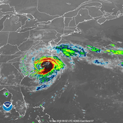
Hurricane Florence 2018
The South Atlantic Water Science Center prepares for Hurricane Florence to make landfall along the Carolina coast.

SAWSC Monitoring of Hydrologic Hazards
A major element of the USGS mission is the documentation of the extent and magnitude of extreme hydrologic events, like floods and droughts. The South Atlantic Water Science Center is a leader in monitoring extreme water conditions, from droughts and falling groundwater levels to floods and storm-tide surges to water-quality problems.

Charlotte-Mecklenburg, N.C., Hydrologic Network
The U.S. Geological Survey (USGS) has been collecting streamflow data in North Carolina for more than 100 years. In the Charlotte and Mecklenburg County area, a hydrologic data-collection network has been established to collect not only streamflow data but also rainfall data. In response to the floods of August 1995 and July 1997, the U.S. Geological Survey Cooperative Water Program and Charlotte...