A view of the lower Little Colorado River (July 2013)
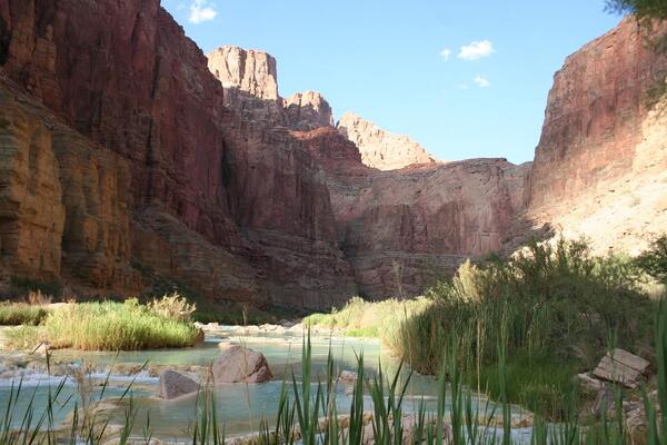
A view of the lower Little Colorado River (July 2013)A view of the lower Little Colorado River, July 2013. Photo by Maria Dzul, USGS.

Official websites use .gov
A .gov website belongs to an official government organization in the United States.
Secure .gov websites use HTTPS
A lock () or https:// means you’ve safely connected to the .gov website. Share sensitive information only on official, secure websites.
Below are images associated with SBSC's science and staff. Images appear according to the year they were taken. To search, type a keyword or select a year from the dropdown menu. Or, click through the pages using the arrows at the bottom of the page.
A view of the lower Little Colorado River, July 2013. Photo by Maria Dzul, USGS.
A view of the lower Little Colorado River, July 2013. Photo by Maria Dzul, USGS.

A photo of a loggerhead shrike next to a desert tortoise burrow, captured by remote camera monitoring of Agassiz's desert tortoise burrows on a wind energy facility near Palm Springs, CA. The study, led by the USGS Southwest Biological Science Center, investigated bird use of desert tortoise burrows.
A photo of a loggerhead shrike next to a desert tortoise burrow, captured by remote camera monitoring of Agassiz's desert tortoise burrows on a wind energy facility near Palm Springs, CA. The study, led by the USGS Southwest Biological Science Center, investigated bird use of desert tortoise burrows.

A Bighorn sheep stands next to the Senita Tank water catchment, also called a tinaja, in Cabeza Prieta National Wildlife Refuge (CPNWR), southern AZ. Photo courtesy of the US Fish and Wildlife Service, CPNWR.
A Bighorn sheep stands next to the Senita Tank water catchment, also called a tinaja, in Cabeza Prieta National Wildlife Refuge (CPNWR), southern AZ. Photo courtesy of the US Fish and Wildlife Service, CPNWR.

USGS and US Forest Service staff installing dust monitoring equipment at a uranium mine near Grand Canyon National Park.
USGS and US Forest Service staff installing dust monitoring equipment at a uranium mine near Grand Canyon National Park.

Grand Canyon sunset from South Rim taken during USGS field work, April 2013.
Grand Canyon sunset from South Rim taken during USGS field work, April 2013.

A scientist completes a zooplankton tow from a boat in Lake Powell. The net pictured here is pulled through through the top 30 m of the reservoir to collect a zooplankton sample for species identification and enumeration. Photo by Robert Radtke, U.S. Bureau of Reclamation.
A scientist completes a zooplankton tow from a boat in Lake Powell. The net pictured here is pulled through through the top 30 m of the reservoir to collect a zooplankton sample for species identification and enumeration. Photo by Robert Radtke, U.S. Bureau of Reclamation.

Bureau of Land Management truck sprays herbicide in southwestern Idaho as part of a restoration effort.
An examination of long-term data for lands managed by the Bureau of Land Management finds that land treatments in the southwestern United States are increasingly large, expensive and related to fire and invasive species control.

This image is of invasive tamarisk (salt cedar) growing on the banks of the Colorado River.
This image is of invasive tamarisk (salt cedar) growing on the banks of the Colorado River.

A weir across Bright Angel Creek in Grand Canyon National Park to prevent non-native fish passage back upstream. Photo courtesy of Brian Healy, formerly with the National Park Service, Grand Canyon National Park, and now with USGS.
A weir across Bright Angel Creek in Grand Canyon National Park to prevent non-native fish passage back upstream. Photo courtesy of Brian Healy, formerly with the National Park Service, Grand Canyon National Park, and now with USGS.

A Seabird water quality profiling instrument, Lake Powell. This instrument is used to collect temperature, conductivity, dissolved oxygen, pH, turbidity, and chlorophyll a data from the reservoir. Water is pumped across the water quality sensors as the instrument is lowered through the water column on a winch. The result is binned estimates of diffe
A Seabird water quality profiling instrument, Lake Powell. This instrument is used to collect temperature, conductivity, dissolved oxygen, pH, turbidity, and chlorophyll a data from the reservoir. Water is pumped across the water quality sensors as the instrument is lowered through the water column on a winch. The result is binned estimates of diffe
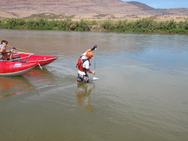
Thomas A. Sabol making a wading Equal-Width-Increment suspended-sediment measurement using a US DH-81 sampler at the Green River above Gates of Lodore, Colorado, gaging station (July 20, 2012). Photo by David Topping, USGS.
Thomas A. Sabol making a wading Equal-Width-Increment suspended-sediment measurement using a US DH-81 sampler at the Green River above Gates of Lodore, Colorado, gaging station (July 20, 2012). Photo by David Topping, USGS.

Dr. Jeff Lovich kneels by a large Western Santa Cruz Giant Tortoise (Chelonoidis niger porteri) in the Galapagos Islands, July 2012. They tortoises are native to Santa Cruz Island in the Galapagos.
Dr. Jeff Lovich kneels by a large Western Santa Cruz Giant Tortoise (Chelonoidis niger porteri) in the Galapagos Islands, July 2012. They tortoises are native to Santa Cruz Island in the Galapagos.
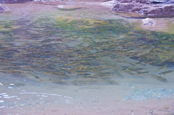
A large group of flannelmouth suckers (Catostomus latipinnis) swim together in the Colorado River near the Little Colorado River confluence.
A large group of flannelmouth suckers (Catostomus latipinnis) swim together in the Colorado River near the Little Colorado River confluence.

Researcher with Humpback Chub during fish seining efforts
Researcher with Humpback Chub during fish seining efforts

Juvenile sand lance collected in a beach seine by USGS Western Fisheries Research Center scientists while conducting a survey for juvenile surf smelt on Bainbridge Island, WA. Like surf smelt, sand lance are an important forage fish in Puget Sound.
Juvenile sand lance collected in a beach seine by USGS Western Fisheries Research Center scientists while conducting a survey for juvenile surf smelt on Bainbridge Island, WA. Like surf smelt, sand lance are an important forage fish in Puget Sound.

USGS Western Fisheries Research Center scientists identify fish collected in a beach seine while conducting a survey for juvenile surf smelt on Bainbridge Island, WA.
USGS Western Fisheries Research Center scientists identify fish collected in a beach seine while conducting a survey for juvenile surf smelt on Bainbridge Island, WA.

Tidepool snailfish collected in a beach seine by USGS Western Fisheries Research Center scientists while conducting a survey for juvenile surf smelt on Bainbridge Island, WA.
Tidepool snailfish collected in a beach seine by USGS Western Fisheries Research Center scientists while conducting a survey for juvenile surf smelt on Bainbridge Island, WA.

Eelgrass beds such as this one found on Bainbridge Island, WA have been identified as a possible primary source of energy to the food chain and may also serve as nursery areas for juvenile forage fish.
Eelgrass beds such as this one found on Bainbridge Island, WA have been identified as a possible primary source of energy to the food chain and may also serve as nursery areas for juvenile forage fish.

Crescent gunnel collected in a beach seine by USGS Western Fisheries Research Center scientists while conducting a survey for juvenile surf smelt on Bainbridge Island, WA.
Crescent gunnel collected in a beach seine by USGS Western Fisheries Research Center scientists while conducting a survey for juvenile surf smelt on Bainbridge Island, WA.

Plainfin midshipman collected in a beach seine by USGS Western Fisheries Research Center scientists while conducting a survey for juvenile surf smelt on Bainbridge Island, WA.
Plainfin midshipman collected in a beach seine by USGS Western Fisheries Research Center scientists while conducting a survey for juvenile surf smelt on Bainbridge Island, WA.

A Graceful Crab (Metacarcinus gracilis) captured in a beach seine during a 2012 Bainbridge Island larval forage fish survey. This survey focused on the abundance, habitat use, and food habits of larval forage fish (surf smelt and sand lance) and was conducted by scientists from the Columbia River Research Laboratory -Western Fisheries R
A Graceful Crab (Metacarcinus gracilis) captured in a beach seine during a 2012 Bainbridge Island larval forage fish survey. This survey focused on the abundance, habitat use, and food habits of larval forage fish (surf smelt and sand lance) and was conducted by scientists from the Columbia River Research Laboratory -Western Fisheries R