
Riparian Vegetation in Grand Canyon: An Overview
Riparian plant communities, associated with rivers and streams, are ecologically and culturally important areas in the southwestern U.S. Despite covering less than 2% of the land area in the southwest, the resources provided by these communities make them valuable to wildlife, the public, scientists, and resource managers.
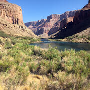
Riparian areas are conspicuous belts of dense, green vegetation along streams and rivers, and can be considered “ribbons of life.” These unique ecosystems act as a link between dry, terrestrial uplands and aquatic ecosystems.
Wildlife come to riparian areas to find food, shelter, and nesting sites.


Riparian plant communities also provide food, shade, and shoreline habitat for aquatic animals including native and non-native fish.
Along the Colorado River between Glen Canyon Dam and Lake Mead, riparian plant communities influence sediment deposition, sandbar stability, wildlife habitat, and experiences of recreational users of the system.

The records from early visitors of the Grand Canyon describe a river corridor with far less vegetation than is seen today.
Prior to the establishment of the Glen Canyon Dam in 1963, the Colorado River would seasonally flood with annual high flows from 85,000 cubic feet per second (cfs) to the highest ever recorded of 210,000 cfs.
These flood events, which are caused by snowmelt in the Rocky Mountains, would presumably scour the Colorado River corridor of plants, leaving sandy beaches and only sparse patches of greenery.

Since the construction of Glen Canyon Dam began to control and regulate flows, vegetation abundance has generally increased, but continually changes in response to varying flow regimes.

In 1938, Elzada Clover and Lois Jotter, botanists from the University of Michigan, conducted the first scientific survey of plants along the river corridor.
For more information on Clover and Jotter's historic expedition, see Women in Science at Grand Canyon and click on "View Media Details" below.
The first botanical research in Grand Canyon consisted mainly of observational surveys, inventories, and collections.
The records from their expedition as well as records left by other early visitors help paint a picture of the pre-dam riparian environment.


The knowledge amassed by all the botanical studies conducted in the Grand Canyon helps us understand how the riparian plant community has changed over time.
Current plant research conducted by GCMRC involves ground-based monitoring, multispectral imagery and lidar, physiological measurements, and controlled greenhouse experiments to further advance the understanding of these plants, their ecological connections, their adaptations, and their responses to the physical environment.


The most significant environment-modifying event in the recent history of Grand Canyon was the construction of Glen Canyon Dam and its associated changes in flow regimes, which began in 1963.
Regulated flows for the first three decades after the construction of the dam were characterized by very large daily fluctuations, until a policy was implemented in 1996 to reduce the daily fluctuations and further regulate changes in flow.


Under regular daily operations, water releases can fluctuate by up to 8,000 cfs, and can reach as high as 25,000 cfs.
This zone of frequent inundation is called the active channel. During high steady releases and High Flow Experiments (HFEs) up to 45,000 cfs of water may pass through Glen Canyon Dam.
The first of these releases was tested in 1996, then again in 2004 and 2008. Starting in 2012, an official protocol for the implementation of HFEs was put in place, allowing more frequent high releases.


HFEs have created a zone that is inundated far less frequently than the active channel, the active floodplain.
Without massive high flows from spring runoff, there is now an inactive floodplain — a relict of a time before the dam when plants would receive once or twice-yearly inundation by flows above 45,000 cfs.


These hydrologic zones created by the Glen Canyon Dam have distinct botanical differences (see "Cross section of the Colorado River channel" illustration, below).
Since the construction of Glen Canyon Dam, the composition of riparian plant communities has changed in response to the changing patterns of the Colorado River.


A stretch of the Colorado River in 1923 and in 2017. Notice the contrast in exposed beach and vegetation encroachment along the bank. Photo on left by E.C. La Rue, and photo on right by H.C. Fairley & A.H. Fairley, USGS.

Below are other science projects associated with this project.
Vegetation monitoring: How one square meter can tell the story of 255 river miles along the Colorado River

Airborne Remote Sensing in Grand Canyon

Riparian Remote Sensing in the Colorado River and Grand Canyon Region
Riparian plant communities, associated with rivers and streams, are ecologically and culturally important areas in the southwestern U.S. Despite covering less than 2% of the land area in the southwest, the resources provided by these communities make them valuable to wildlife, the public, scientists, and resource managers.
Riparian areas are conspicuous belts of dense, green vegetation along streams and rivers, and can be considered “ribbons of life.” These unique ecosystems act as a link between dry, terrestrial uplands and aquatic ecosystems.
Wildlife come to riparian areas to find food, shelter, and nesting sites.
Riparian plant communities also provide food, shade, and shoreline habitat for aquatic animals including native and non-native fish.
Along the Colorado River between Glen Canyon Dam and Lake Mead, riparian plant communities influence sediment deposition, sandbar stability, wildlife habitat, and experiences of recreational users of the system.
The records from early visitors of the Grand Canyon describe a river corridor with far less vegetation than is seen today.
Prior to the establishment of the Glen Canyon Dam in 1963, the Colorado River would seasonally flood with annual high flows from 85,000 cubic feet per second (cfs) to the highest ever recorded of 210,000 cfs.
These flood events, which are caused by snowmelt in the Rocky Mountains, would presumably scour the Colorado River corridor of plants, leaving sandy beaches and only sparse patches of greenery.
Since the construction of Glen Canyon Dam began to control and regulate flows, vegetation abundance has generally increased, but continually changes in response to varying flow regimes.
In 1938, Elzada Clover and Lois Jotter, botanists from the University of Michigan, conducted the first scientific survey of plants along the river corridor.
For more information on Clover and Jotter's historic expedition, see Women in Science at Grand Canyon and click on "View Media Details" below.
The first botanical research in Grand Canyon consisted mainly of observational surveys, inventories, and collections.
The records from their expedition as well as records left by other early visitors help paint a picture of the pre-dam riparian environment.
The knowledge amassed by all the botanical studies conducted in the Grand Canyon helps us understand how the riparian plant community has changed over time.
Current plant research conducted by GCMRC involves ground-based monitoring, multispectral imagery and lidar, physiological measurements, and controlled greenhouse experiments to further advance the understanding of these plants, their ecological connections, their adaptations, and their responses to the physical environment.
The most significant environment-modifying event in the recent history of Grand Canyon was the construction of Glen Canyon Dam and its associated changes in flow regimes, which began in 1963.
Regulated flows for the first three decades after the construction of the dam were characterized by very large daily fluctuations, until a policy was implemented in 1996 to reduce the daily fluctuations and further regulate changes in flow.
Under regular daily operations, water releases can fluctuate by up to 8,000 cfs, and can reach as high as 25,000 cfs.
This zone of frequent inundation is called the active channel. During high steady releases and High Flow Experiments (HFEs) up to 45,000 cfs of water may pass through Glen Canyon Dam.
The first of these releases was tested in 1996, then again in 2004 and 2008. Starting in 2012, an official protocol for the implementation of HFEs was put in place, allowing more frequent high releases.
HFEs have created a zone that is inundated far less frequently than the active channel, the active floodplain.
Without massive high flows from spring runoff, there is now an inactive floodplain — a relict of a time before the dam when plants would receive once or twice-yearly inundation by flows above 45,000 cfs.
These hydrologic zones created by the Glen Canyon Dam have distinct botanical differences (see "Cross section of the Colorado River channel" illustration, below).
Since the construction of Glen Canyon Dam, the composition of riparian plant communities has changed in response to the changing patterns of the Colorado River.
A stretch of the Colorado River in 1923 and in 2017. Notice the contrast in exposed beach and vegetation encroachment along the bank. Photo on left by E.C. La Rue, and photo on right by H.C. Fairley & A.H. Fairley, USGS.
Below are other science projects associated with this project.
Vegetation monitoring: How one square meter can tell the story of 255 river miles along the Colorado River
Airborne Remote Sensing in Grand Canyon