
Hydrogeomorphic Classification and Conceptual Model
The overall objective of this study is to develop a hydrogeomorphic based conceptual model and hierarchical classification system for the UMRS. This model and classification system will build off the existing classification systems for the UMRS with a new aspect of potential for geomorphic change.
There is an expansive body of scientific research and monitoring for the Upper Mississippi River System (UMRS) concerning long and short-term changes in geomorphic patterns, processes, and rates of change. Information gaps exist for a basin-wide synthesis of recent research and effects from multiple human alterations at various scales (land-use change, dam construction, navigation, flow regulation, shore hardening, and channelization of lower tributary valleys) on sediment and flow connectivity among aquatic areas of the river system. There also is a need to describe potential future trajectories of geomorphic evolution of the river given past and present human-imposed constraints. With knowledge of a broader context of hydrogeomorphic settings, local changes in sediment transport, channel morphometry, hydraulic connectivity, floodplain and aquatic vegetation, and ultimately aquatic and riparian habitats can be better described in terms of both basin-wide and locally derived factors. This system-wide framework will provide a context for targeting research and monitoring efforts as well as for evaluating performance of past restoration projects (known as habitat restoration and enhancement projects, or HREPs) and improving the design of future HREPs.
During the 2018 Upper Mississippi River Restoration (UMRR) Meeting hosted at the Upper Midwest Environmental Sciences Center (UMESC), a working group formed that had a focus on Geomorphic Change in the UMRS. This working group prioritized theme one which covered the following:
- Understanding Changes in Geomorphology and Their Implications for the Structure and Function of the UMRS: The geomorphology of the Upper Mississippi River and its floodplain is the physical template on which biotic and abiotic processes occur. The combination of that physical template and those processes determine the distribution and abundance of habitat and rates of critical biological processes. Those biological processes include population and community dynamics of the complex biota supported by the river and biogeochemical processes such as nutrient cycling and oxygen demand/production.
The geomorphic change working group created the project titled “Conceptual Model and Hierarchical Classification of Hydrogeomorphic Settings in the UMRS”.
Products from 2018-2020 project:
- Fall 2018 Workshop with subject matter experts and stakeholders.
- Presentation to working group, LTRM researchers, HREP designers, and state resource agency partners.
- GIS database and query tool draft
- LTRM Completion report (still in production)
Examples of relevant data sources used for the conceptual model and hierarchical classification system:
- UMRR Aquatic Areas
- USACE Landform Sediment Assemblages (LSA)
- Planform change mapping
- Flood Inundation mapping
The November 2018 Geomorphic Workshop Outcomes:
A rough UMRS conceptual model was put together to share with scientists and managers.
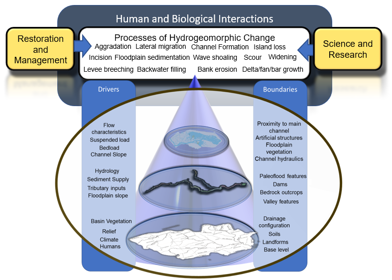
The goal of a conceptual model is to bring together restoration and management with science and research components of the activities being done across the basin by range of state and federal agencies.
Also, during the 2018 workshop a hierarchical classification was brainstormed and put together.

The classification draws from existing framework and literature that was compiled by the core team.
During the 2020 UMRR Science Meeting, again hosted at UMESC, the same working group convened with the original core team and new members. During this meeting it was determined the UMRS conceptual model and classification system could be built upon.
The objective for the 2020-2022 project are to map potential hydrogeomorphic change characteristics for hydrogeomorphic unit and catena levels and provide a more fully developed and vetted GIS-based database and query tool that would be available to both scientists and engineers working on UMRR studies and HREP planning and design. These goals will be met through the following objectives : 1) acquire and assemble existing spatial data layers related to the hydrogeomorphic change hierarchical classification system, 2) generate additional and new characteristics that are needed to describe the common processes potentially causing hydrogeomorphic change, 3) provide maps and interpretive analyses on the spatial distribution and causes for erosion and deposition responsible for changing hydraulic distributions, landform characteristics, ecology, and water quality in the UMRS, and 4) provide a query-based GIS tool for use in scientific studies and HREP plans. In order to complete these goals an on-site geomorphologist is necessary to be able to provide the close attention and guidance needed for the GIS database development team.
UMRR 2020 Meeting Working Group 1: Hydrologic and geomorphic changes projects for 2020-2022
- Mapping Potential Sensitivity to Hydrogeomorphic Change in the UMRS Riverscape and Development of Supporting GIS Database and Query Tool
- Improving our understanding of historic, contemporary, and future UMRS hydrology by improving workflows, reducing redundancies, and setting a blueprint for modelling potential future hydrology
Products for 2020 – 2022 projects
- Finalize a GIS database with compilation of existing datasets
- Mapped hydrogeomorphic units and catena
- GIS Database and query tool
- Write journal articles(s) and report. In addition to at least one journal article on the classification system, we also anticipate a peer-reviewed manuscript that describes the floodplain hydrogeomorphic units and their distribution and relationships with floodplain forest communities in the UMRS.
The overall objective of this study is to develop a hydrogeomorphic based conceptual model and hierarchical classification system for the UMRS. This model and classification system will build off the existing classification systems for the UMRS with a new aspect of potential for geomorphic change.
There is an expansive body of scientific research and monitoring for the Upper Mississippi River System (UMRS) concerning long and short-term changes in geomorphic patterns, processes, and rates of change. Information gaps exist for a basin-wide synthesis of recent research and effects from multiple human alterations at various scales (land-use change, dam construction, navigation, flow regulation, shore hardening, and channelization of lower tributary valleys) on sediment and flow connectivity among aquatic areas of the river system. There also is a need to describe potential future trajectories of geomorphic evolution of the river given past and present human-imposed constraints. With knowledge of a broader context of hydrogeomorphic settings, local changes in sediment transport, channel morphometry, hydraulic connectivity, floodplain and aquatic vegetation, and ultimately aquatic and riparian habitats can be better described in terms of both basin-wide and locally derived factors. This system-wide framework will provide a context for targeting research and monitoring efforts as well as for evaluating performance of past restoration projects (known as habitat restoration and enhancement projects, or HREPs) and improving the design of future HREPs.
During the 2018 Upper Mississippi River Restoration (UMRR) Meeting hosted at the Upper Midwest Environmental Sciences Center (UMESC), a working group formed that had a focus on Geomorphic Change in the UMRS. This working group prioritized theme one which covered the following:
- Understanding Changes in Geomorphology and Their Implications for the Structure and Function of the UMRS: The geomorphology of the Upper Mississippi River and its floodplain is the physical template on which biotic and abiotic processes occur. The combination of that physical template and those processes determine the distribution and abundance of habitat and rates of critical biological processes. Those biological processes include population and community dynamics of the complex biota supported by the river and biogeochemical processes such as nutrient cycling and oxygen demand/production.
The geomorphic change working group created the project titled “Conceptual Model and Hierarchical Classification of Hydrogeomorphic Settings in the UMRS”.
Products from 2018-2020 project:
- Fall 2018 Workshop with subject matter experts and stakeholders.
- Presentation to working group, LTRM researchers, HREP designers, and state resource agency partners.
- GIS database and query tool draft
- LTRM Completion report (still in production)
Examples of relevant data sources used for the conceptual model and hierarchical classification system:
- UMRR Aquatic Areas
- USACE Landform Sediment Assemblages (LSA)
- Planform change mapping
- Flood Inundation mapping
The November 2018 Geomorphic Workshop Outcomes:
A rough UMRS conceptual model was put together to share with scientists and managers.
The goal of a conceptual model is to bring together restoration and management with science and research components of the activities being done across the basin by range of state and federal agencies.
Also, during the 2018 workshop a hierarchical classification was brainstormed and put together.
The classification draws from existing framework and literature that was compiled by the core team.
During the 2020 UMRR Science Meeting, again hosted at UMESC, the same working group convened with the original core team and new members. During this meeting it was determined the UMRS conceptual model and classification system could be built upon.
The objective for the 2020-2022 project are to map potential hydrogeomorphic change characteristics for hydrogeomorphic unit and catena levels and provide a more fully developed and vetted GIS-based database and query tool that would be available to both scientists and engineers working on UMRR studies and HREP planning and design. These goals will be met through the following objectives : 1) acquire and assemble existing spatial data layers related to the hydrogeomorphic change hierarchical classification system, 2) generate additional and new characteristics that are needed to describe the common processes potentially causing hydrogeomorphic change, 3) provide maps and interpretive analyses on the spatial distribution and causes for erosion and deposition responsible for changing hydraulic distributions, landform characteristics, ecology, and water quality in the UMRS, and 4) provide a query-based GIS tool for use in scientific studies and HREP plans. In order to complete these goals an on-site geomorphologist is necessary to be able to provide the close attention and guidance needed for the GIS database development team.
UMRR 2020 Meeting Working Group 1: Hydrologic and geomorphic changes projects for 2020-2022
- Mapping Potential Sensitivity to Hydrogeomorphic Change in the UMRS Riverscape and Development of Supporting GIS Database and Query Tool
- Improving our understanding of historic, contemporary, and future UMRS hydrology by improving workflows, reducing redundancies, and setting a blueprint for modelling potential future hydrology
Products for 2020 – 2022 projects
- Finalize a GIS database with compilation of existing datasets
- Mapped hydrogeomorphic units and catena
- GIS Database and query tool
- Write journal articles(s) and report. In addition to at least one journal article on the classification system, we also anticipate a peer-reviewed manuscript that describes the floodplain hydrogeomorphic units and their distribution and relationships with floodplain forest communities in the UMRS.