
Hydrogeologic Framework Delineation and Mapping
Processing sediment cuttings in Accomack County
Courtesy of Scott Bruce, DEQ
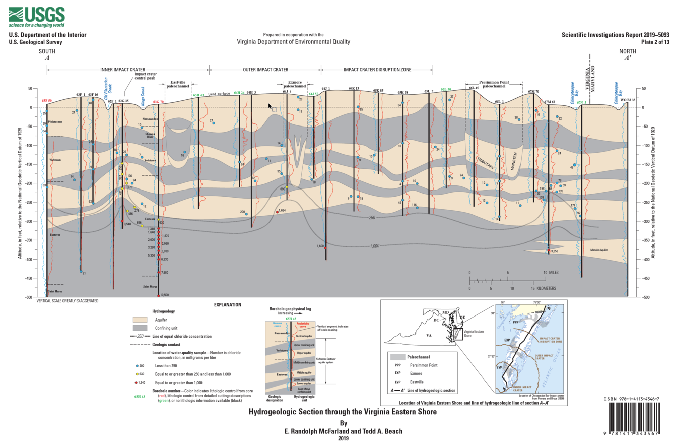
A recently published report and associated data release on the hydrogeologic framework of the Virginia Eastern Shore reflect a substantially improved understanding of groundwater hydrogeology in this sole-source aquifer system. The identification and mapping of three buried paleochannels is especially important because of the effect of these features on local groundwater flow.
Using recently available expanded information, the U.S. Geological Survey (USGS) undertook a study in cooperation with the Virginia Department of Environmental Quality during 2016–19 to develop an improved description of the Eastern Shore groundwater system, or hydrogeologic framework, resulting in a 2019 USGS Scientific Investigations Report and accompanying Data Release. On-going data collection and interpretive activities by USGS and VDEQ will be used to update and revise this hydrogeologic framework in the future at appropriate intervals.
On the basis of geophysical logs and other information from 205 boreholes, Miocene- to Pliocene-age marine-shelf sediments of the Yorktown-Eastover aquifer system are designated to include upper, middle, and lower confined aquifers overlain by correspondingly named confining units and underlain by the Saint Marys confining unit. The aquifers are composed of medium- to coarse-grained sand and shell and the confining units consist of fine-grained sand, silt, and clay. An overlying surficial aquifer is composed mostly of Pleistocene-age nearshore sand and gravel with smaller amounts of cobbles and boulders.
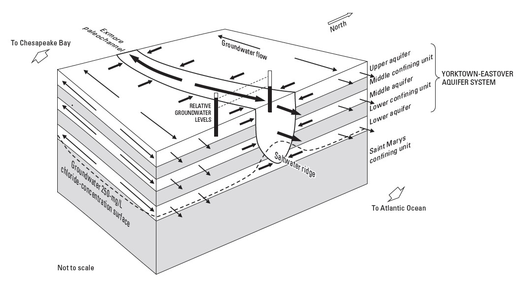
The aquifers and confining units are also variably incised by three Pleistocene-age paleochannels of fluvial and estuarine sediments along an upward-widening and eastward-lengthening series of structural “windows.” The upper confining unit overlies the upper aquifer and—where present—the paleochannels. This characterization is the first explicit delineation of sediments that fill the paleochannels as distinct hydrogeologic units. The aquifers consist of medium- to coarse-grained sand and gravel, and the intervening confining unit consists of fine-grained sand, silt, clay, and organic material. Aquifer and confining-unit sediments are also mixed with reworked marine-shelf sediments eroded from the sides of the paleochannels.
Estimated aquifer hydraulic properties at 58 wells on the Virginia Eastern Shore were compiled from records on file with the Virginia DEQ. Results of documented aquifer tests include 133 estimates of aquifer transmissivity, 85 estimates of storativity, and 18 estimates of specific yield. Estimates of transmissivity indicate differences in productivity among the aquifers. Transmissivity is generally greatest in young, shallow, and coarse-grained nearshore and fluvial sediments of the surficial aquifer and paleochannel lower aquifer. Transmissivity progressively decreases with depth in older, deeper, and finer grained marine-shelf sediments of the Yorktown-Eastover aquifer system.
Chloride concentrations in 2,440 samples collected from 330 wells on the Virginia Eastern Shore during 1906–2016 were compiled from databases of the USGS and Virginia DEQ and from published sources. Chloride concentration generally increases downward, with most of the samples collected at altitudes above −300 ft and having concentrations less than the 250-milligram-per-liter (mg/L) U.S. Environmental Protection Agency secondary maximum contaminant level. Chloride concentrations plotted on a hydrogeologic section and used to delineate a 250-mg/L chloride-concentration surface indicate that the saltwater-transition zone has a broad, trough-like shape aligned with the peninsula. Saltwater is relatively shallow along the coastline and generally deeper near the central “spine” of the peninsula, approximately coinciding with the top of the Saint Marys confining unit.
Hydrologic Section through the Virginia Eastern Shore.
Generalized hydrologic relations among aquifers and the Exmore paleochannel on the Virginia Eastern Shore. The surficial aquifer and upper confining unit are omitted for clarity. Hydrogeologic units within the Exmore paleochannel are not distinguished. Weight of arrow denotes relative flow weight. mg/L, milligrams per liter.
Simplified stratigraphic relations among hydrologic units and geologic formations of the Virginia Eastern Shore.
