
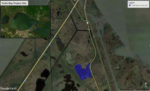
Investigation of Hydrology and Inundation of the Turtle Bayou Mitigation Area within Bayou Sauvage National Wildlife Refuge, Louisiana
USGS will monitor hydrologic and marsh conditions at the Turtle Bayou mitigation area. This effort will help provide a long-term water level dataset for Turtle Bayou.
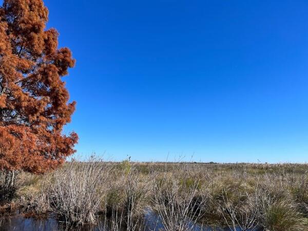
The Science Issue and Relevance: Hydrology of the impounded (interior) marshes within the Bayou Sauvage National Wildlife Refuge (BSNWR) in Louisiana is complex. Water exchange between open channels, lakes and the adjacent marsh is based on the gradient and fluctuation of water surface elevation (water level) and the surrounding marsh elevation. In addition, obstructions such as spoil banks, levees, and vegetated floodplains can act to limit and/or slow water exchange between the open water and the marsh. These interior marshes are dependent on a combination of natural climate conditions; specifically, precipitation, evapotranspiration, and water management within the BSNWR that can change water level gradients within these areas.
The U.S. Army Corp of Engineers (USACE) recently completed a mitigation project in the Turtle Bayou area of the BSNWR. This mitigation area has the potential to enhance the area by providing beneficial marsh habitat. However, the marsh platform has been slow to settle so additional monitoring of the mitigation area is needed.
Methodology for Addressing the Issue: This study will help determine hydrologic and marsh conditions (levels and gradients) within and surrounding the Turtle Bayou mitigation (TBM) area in BSNWR to determine surface water exchange in the area. This will be done with the use of continuous water level loggers recording surface water levels and using real-time kinematic (RTK) positioning to measure marsh elevation within the mitigation area. Survey will start in early 2024, with water level logger data collected over a 1-year period. This survey period may be extended if deemed necessary to further evaluate success criteria. Water level and elevation results will be reviewed and verified using USGS quality assurance and quality control procedures and will be peer reviewed and approved after collection.
Future Steps: The project will help provide a long-term water level dataset from the gage that will capture effects from hurricanes, droughts and major water management control events performed by the U.S. Fish and Wildlife to manage water resources within BSNWR. These hydrologic changes will effectively drain and flood the marsh and influence water inundation at the TBM area.
USGS will monitor hydrologic and marsh conditions at the Turtle Bayou mitigation area. This effort will help provide a long-term water level dataset for Turtle Bayou.
The Science Issue and Relevance: Hydrology of the impounded (interior) marshes within the Bayou Sauvage National Wildlife Refuge (BSNWR) in Louisiana is complex. Water exchange between open channels, lakes and the adjacent marsh is based on the gradient and fluctuation of water surface elevation (water level) and the surrounding marsh elevation. In addition, obstructions such as spoil banks, levees, and vegetated floodplains can act to limit and/or slow water exchange between the open water and the marsh. These interior marshes are dependent on a combination of natural climate conditions; specifically, precipitation, evapotranspiration, and water management within the BSNWR that can change water level gradients within these areas.
The U.S. Army Corp of Engineers (USACE) recently completed a mitigation project in the Turtle Bayou area of the BSNWR. This mitigation area has the potential to enhance the area by providing beneficial marsh habitat. However, the marsh platform has been slow to settle so additional monitoring of the mitigation area is needed.
Methodology for Addressing the Issue: This study will help determine hydrologic and marsh conditions (levels and gradients) within and surrounding the Turtle Bayou mitigation (TBM) area in BSNWR to determine surface water exchange in the area. This will be done with the use of continuous water level loggers recording surface water levels and using real-time kinematic (RTK) positioning to measure marsh elevation within the mitigation area. Survey will start in early 2024, with water level logger data collected over a 1-year period. This survey period may be extended if deemed necessary to further evaluate success criteria. Water level and elevation results will be reviewed and verified using USGS quality assurance and quality control procedures and will be peer reviewed and approved after collection.
Future Steps: The project will help provide a long-term water level dataset from the gage that will capture effects from hurricanes, droughts and major water management control events performed by the U.S. Fish and Wildlife to manage water resources within BSNWR. These hydrologic changes will effectively drain and flood the marsh and influence water inundation at the TBM area.